Saldus elevation
Saldus (Saldus Rajons), Latvia elevation is 92 meters and Saldus elevation in feet is 302 ft above sea level [src 1]. Saldus is a seat of a first-order administrative division (feature code) with elevation that is 26 meters (85 ft) bigger than average city elevation in Latvia.
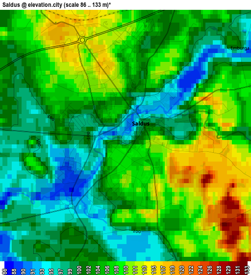
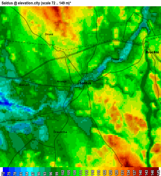
Below is the Elevation map of Saldus, which displays elevation range with different colors. Scale of the first map is from 86 to 133 m (282 to 436 ft) with average elevation of 104.4 meters (=343 ft) [note 1]
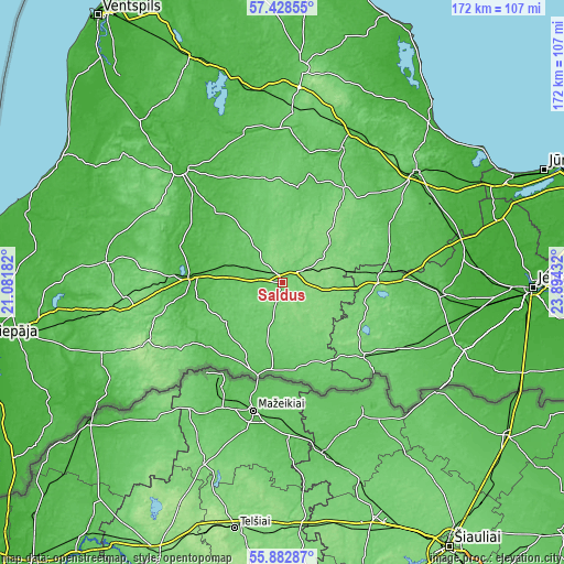
These maps also provides idea of topography and contour of this city, they are displayed at different zoom levels. More info about maps, scale and edge coordinates you can find below images.
| \ | Map #1 | Map #2 | Topo.Map |
| Scale [m] | 86..133 m | 72..149 m | × |
| Scale [ft] | 282..436 ft | 236..489 ft | × |
| Average | 104.4 m = 343 ft | 106.4 m = 349 ft | × |
| Width | 5.37 km = 3.3 mi | 10.74 km = 6.7 mi | 171.9 km = 106.8 mi |
| Height | 5.37 km = 3.3 mi | 10.74 km = 6.7 mi | 171.8 km = 106.8 mi |
| ↑Max Latitude | 56.687773° | 56.7119° | 57.42855° |
| Latitude at center | 56.66363° | 56.66363° | 56.66363° |
| ↓Min Latitude | 56.639472° | 56.615298° | 55.88287° |
| ← Min Longitude | 22.444125° | 22.400179° | 21.08182° |
| Longitude center | 22.48807° | 22.48807° | 22.48807° |
| →Max Longitude | 22.532015° | 22.575961° | 23.89432° |
Nearby cities:
Cities around Saldus sort by population:
• Tukums elevation 63 m
52.8 km,  50°
50°
• Kuldīga 28 m
47.3 km,  316°
316°
• Dobele 55 m
48.3 km,  95°
95°
• Aizpute 74 m
54.5 km,  276°
276°
• Kandava 81 m
45.4 km,  22°
22°
• Brocēni 127 m
5.3 km,  71°
71°
• Auce 91 m
34 km,  131°
131°
• Skrunda 43 m
28.9 km,  273°
273°
• Stende 91 m
53.6 km,  3°
3°
• Sabile 40 m
42.8 km,  6°
6°
• Jaunpils 72 m
32.9 km,  76°
76°
• Vaiņode 161 m
47.5 km,  234°
234°
Multilingual:
 En español:
Saldus elevación 92 m.
 En France:
Saldus élévation 92 m.


Sources and notes:
- [note 1] Map square and city borders are not equal. Map elevation data is calculated only from area inside that square.
- [src 1] Elevation data from geonames database provided with same terms of usage.
- [src 2] The elevation map of Saldus is generated using elevation data from NASA's 3 arcsec (90m) resolution SRTM data.
- [src 3] Base (background) map © OpenStreetMap contributors tiles are generated by Geofabrik and OpenTopoMap.
Copyright & License:
This Saldus Elevation Map is licensed under CC BY-SA. You may reuse any part from this page, if you give a proper credit by linking to this URL:
 More info on terms of use page.