Valka elevation
Valka, Latvia elevation is 53 meters and Valka elevation in feet is 174 ft above sea level [src 1]. Valka is a seat of a first-order administrative division (feature code) with elevation that is 13 meters (43 ft) smaller than average city elevation in Latvia.
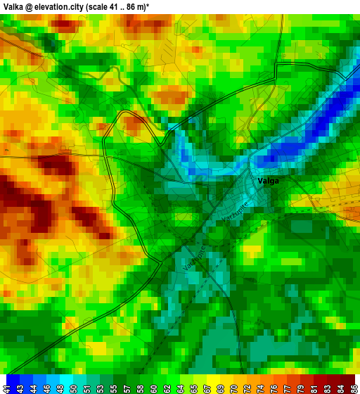
Below is the Elevation map of Valka, which displays elevation range with different colors. Scale of the first map is from 41 to 86 m (135 to 282 ft) with average elevation of 62.1 meters (=204 ft) [note 1]
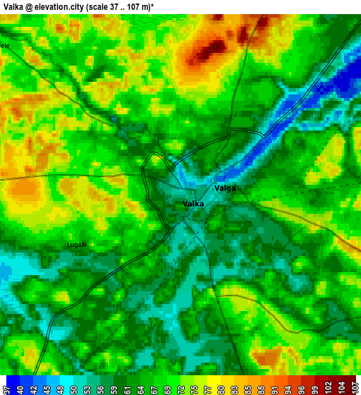
These maps also provides idea of topography and contour of this city, they are displayed at different zoom levels. More info about maps, scale and edge coordinates you can find below images.
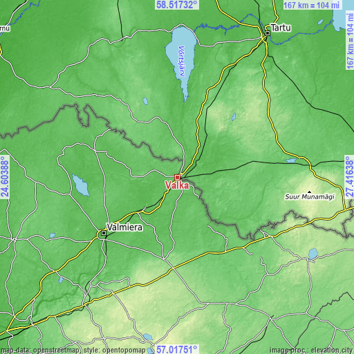
| \ | Map #1 | Map #2 | Topo.Map |
| Scale [m] | 41..86 m | 37..107 m | × |
| Scale [ft] | 135..282 ft | 121..351 ft | × |
| Average | 62.1 m = 204 ft | 66.7 m = 219 ft | × |
| Width | 5.21 km = 3.2 mi | 10.42 km = 6.5 mi | 166.8 km = 103.6 mi |
| Height | 5.21 km = 3.2 mi | 10.42 km = 6.5 mi | 166.7 km = 103.6 mi |
| ↑Max Latitude | 57.798626° | 57.822037° | 58.51732° |
| Latitude at center | 57.7752° | 57.7752° | 57.7752° |
| ↓Min Latitude | 57.751759° | 57.728303° | 57.01751° |
| ← Min Longitude | 25.966185° | 25.922239° | 24.60388° |
| Longitude center | 26.01013° | 26.01013° | 26.01013° |
| →Max Longitude | 26.054075° | 26.098021° | 27.41638° |
Nearby cities:
Cities around Valka sort by population:
• Valmiera elevation 43 m
43.3 km,  233°
233°
• Smiltene 98 m
39.5 km,  189°
189°
• Rūjiena 62 m
42.4 km,  288°
288°
• Mazsalaca 58 m
57.4 km,  279°
279°
• Seda 54 m
20.7 km, 227°
• Strenči 45 m
25.5 km, 229°
• Ape 82 m
48.3 km,  122°
122°
• Rauna 114 m
54.8 km,  205°
205°
• Matīši 69 m
51.2 km,  260°
260°
• Kocēni 62 m
49 km, 234°
• Mūrmuiža 57 m
45.6 km,  222°
222°
• Naukšēni 51 m
34.9 km, 290°
Multilingual:
 En español:
Valka elevación 53 m.
 En France:
Valka élévation 53 m.


Sources and notes:
- [note 1] Map square and city borders are not equal. Map elevation data is calculated only from area inside that square.
- [src 1] Elevation data from geonames database provided with same terms of usage.
- [src 2] The elevation map of Valka is generated using elevation data from NASA's 3 arcsec (90m) resolution SRTM data.
- [src 3] Base (background) map © OpenStreetMap contributors tiles are generated by Geofabrik and OpenTopoMap.
Copyright & License:
This Valka Elevation Map is licensed under CC BY-SA. You may reuse any part from this page, if you give a proper credit by linking to this URL:
 More info on terms of use page.