Ventspils elevation
Ventspils, Latvia elevation is 7 meters and Ventspils elevation in feet is 23 ft above sea level [src 1]. Ventspils is a seat of a first-order administrative division (feature code) with elevation that is 59 meters (194 ft) smaller than average city elevation in Latvia.
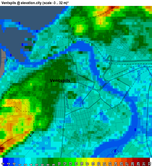
Below is the Elevation map of Ventspils, which displays elevation range with different colors. Scale of the first map is from -3 to 32 m (-10 to 105 ft) with average elevation of 6.2 meters (=20 ft) [note 1]
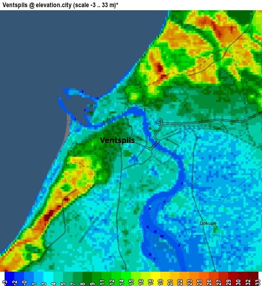
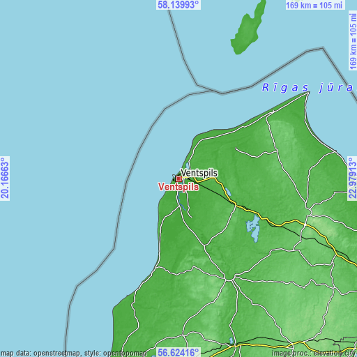
These maps also provides idea of topography and contour of this city, they are displayed at different zoom levels. More info about maps, scale and edge coordinates you can find below images.
| \ | Map #1 | Map #2 | Topo.Map |
| Scale [m] | -3..32 m | -3..33 m | × |
| Scale [ft] | -10..105 ft | -10..108 ft | × |
| Average | 6.2 m = 20 ft | 7.2 m = 24 ft | × |
| Width | 5.27 km = 3.3 mi | 10.53 km = 6.5 mi | 168.5 km = 104.7 mi |
| Height | 5.27 km = 3.3 mi | 10.53 km = 6.5 mi | 168.5 km = 104.7 mi |
| ↑Max Latitude | 57.413555° | 57.437215° | 58.13993° |
| Latitude at center | 57.38988° | 57.38988° | 57.38988° |
| ↓Min Latitude | 57.366189° | 57.342483° | 56.62416° |
| ← Min Longitude | 21.528935° | 21.484989° | 20.16663° |
| Longitude center | 21.57288° | 21.57288° | 21.57288° |
| →Max Longitude | 21.616825° | 21.660771° | 22.97913° |
Nearby cities:
Cities around Ventspils sort by population:
• Kuldīga elevation 28 m
51.7 km,  153°
153°
• Talsi 76 m
62.6 km,  104°
104°
• Aizpute 74 m
74.4 km,  178°
178°
• Kandava 81 m
82.1 km,  118°
118°
• Stende 91 m
63.9 km, 115°
• Roja 13 m
75 km,  80°
80°
• Sabile 40 m
71.3 km, 122°
• Valdemārpils 56 m
61.1 km,  92°
92°
• Pāvilosta 8 m
60.5 km,  202°
202°
• Piltene 7 m
19.4 km,  161°
161°
• Alsunga 33 m
45.4 km, 181°
• Dundaga 63 m
48.2 km,  74°
74°
Multilingual:
 En español:
Ventspils elevación 7 m.
 En France:
Ventspils élévation 7 m.


Sources and notes:
- [note 1] Map square and city borders are not equal. Map elevation data is calculated only from area inside that square.
- [src 1] Elevation data from geonames database provided with same terms of usage.
- [src 2] The elevation map of Ventspils is generated using elevation data from NASA's 3 arcsec (90m) resolution SRTM data.
- [src 3] Base (background) map © OpenStreetMap contributors tiles are generated by Geofabrik and OpenTopoMap.
Copyright & License:
This Ventspils Elevation Map is licensed under CC BY-SA. You may reuse any part from this page, if you give a proper credit by linking to this URL:
 More info on terms of use page.