Bous elevation
Bous (Remich), Luxembourg elevation is 155 meters and Bous elevation in feet is 509 ft above sea level [src 1]. Bous is a seat of a third-order administrative division (feature code) with elevation that is 133 meters (436 ft) smaller than average city elevation in Luxembourg.
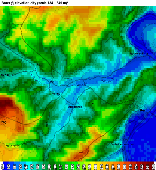
Below is the Elevation map of Bous, which displays elevation range with different colors. Scale of the first map is from 134 to 349 m (440 to 1145 ft) with average elevation of 208.5 meters (=684 ft) [note 1]
These maps also provides idea of topography and contour of this city, they are displayed at different zoom levels. More info about maps, scale and edge coordinates you can find below images.
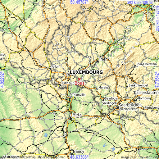
| \ | Map #1 | Topo.Map |
| Scale [m] | 134..349 m | × |
| Scale [ft] | 440..1145 ft | × |
| Average | 208.5 m = 684 ft | × |
| Width | 6.34 km = 3.9 mi | 202.9 km = 126.1 mi |
| Height | 6.34 km = 3.9 mi | 202.9 km = 126.1 mi |
| ↑Max Latitude | 49.58239° | 50.45767° |
| Latitude at center | 49.55389° | 49.55389° |
| ↓Min Latitude | 49.525373° | 48.63308° |
| ← Min Longitude | 6.285225° | 4.92292° |
| Longitude center | 6.32917° | 6.32917° |
| →Max Longitude | 6.373115° | 7.73542° |
Nearby cities:
Cities around Bous sort by population:
• Remich elevation 160 m
2.9 km,  109°
109°
• Mondorf-les-Bains 191 m
6.4 km,  212°
212°
• Dalheim 309 m
5.2 km,  253°
253°
• Moutfort 257 m
6.4 km,  303°
303°
• Contern 333 m
8 km,  292°
292°
• Schrassig 251 m
8 km,  321°
321°
• Aspelt 242 m
8.3 km, 245°
• Schuttrange 246 m
8.6 km,  329°
329°
• Wormeldange 147 m
8.4 km,  40°
40°
• Stadtbredimus 147 m
2.7 km,  68°
68°
• Waldbredimus 183 m
3 km,  276°
276°
• Lenningen 179 m
5.9 km,  27°
27°
Multilingual:
 En español:
Bous elevación 155 m.
 En France:
Bous élévation 155 m.


Sources and notes:
- [note 1] Map square and city borders are not equal. Map elevation data is calculated only from area inside that square.
- [src 1] Elevation data from geonames database provided with same terms of usage.
- [src 2] The elevation map of Bous is generated using elevation data from NASA's 3 arcsec (90m) resolution SRTM data.
- [src 3] Base (background) map © OpenStreetMap contributors tiles are generated by Geofabrik and OpenTopoMap.
Copyright & License:
This Bous Elevation Map is licensed under CC BY-SA. You may reuse any part from this page, if you give a proper credit by linking to this URL:
 More info on terms of use page.