Nemenčinė elevation
Nemenčinė (Vilnius, Vilnius District Municipality), Lithuania elevation is 116 meters and Nemenčinė elevation in feet is 381 ft above sea level [src 1]. Nemenčinė is a populated place (feature code) with elevation that is 23 meters (75 ft) bigger than average city elevation in Lithuania.
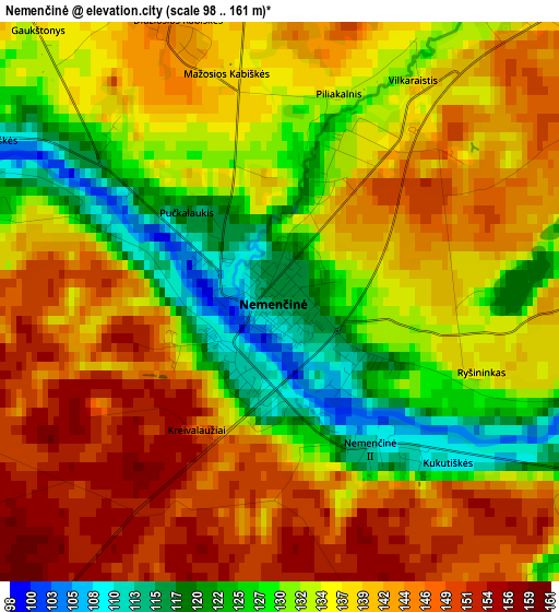
Below is the Elevation map of Nemenčinė, which displays elevation range with different colors. Scale of the first map is from 98 to 161 m (322 to 528 ft) with average elevation of 136.4 meters (=448 ft) [note 1]
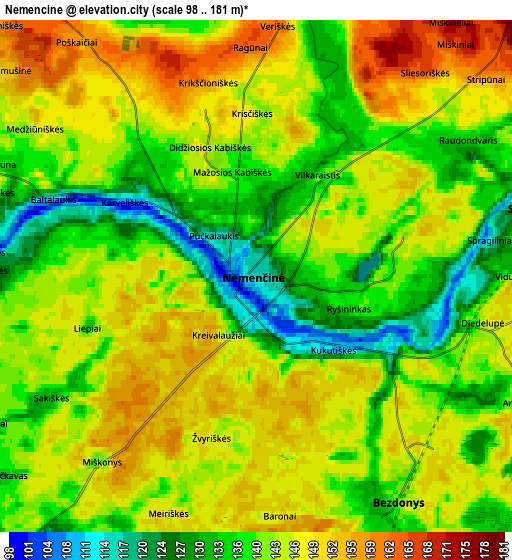
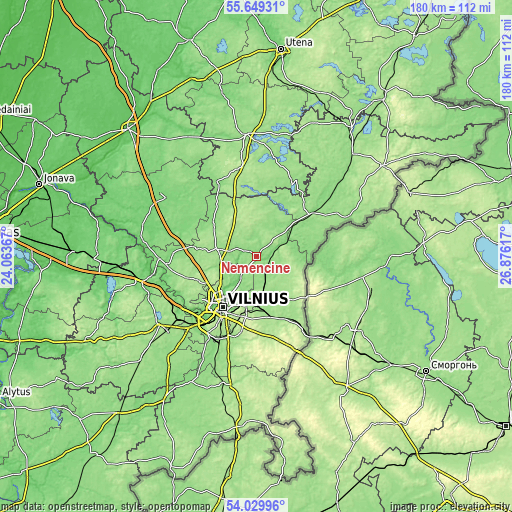
These maps also provides idea of topography and contour of this city, they are displayed at different zoom levels. More info about maps, scale and edge coordinates you can find below images.
| \ | Map #1 | Map #2 | Topo.Map |
| Scale [m] | 98..161 m | 98..181 m | × |
| Scale [ft] | 322..528 ft | 322..594 ft | × |
| Average | 136.4 m = 448 ft | 142.4 m = 467 ft | × |
| Width | 5.63 km = 3.5 mi | 11.25 km = 7 mi | 180.1 km = 111.9 mi |
| Height | 5.63 km = 3.5 mi | 11.25 km = 7 mi | 180 km = 111.8 mi |
| ↑Max Latitude | 54.873054° | 54.898331° | 55.64931° |
| Latitude at center | 54.84776° | 54.84776° | 54.84776° |
| ↓Min Latitude | 54.822451° | 54.797125° | 54.02996° |
| ← Min Longitude | 25.425975° | 25.382029° | 24.06367° |
| Longitude center | 25.46992° | 25.46992° | 25.46992° |
| →Max Longitude | 25.513865° | 25.557811° | 26.87617° |
Nearby cities:
Cities around Nemenčinė sort by population:
• Vilnius elevation 98 m
21.4 km,  214°
214°
• Fabijoniškės 184 m
19.4 km,  228°
228°
• Pašilaičiai 173 m
20.4 km, 231°
• Šeškinė 165 m
20.8 km,  222°
222°
• Lazdynai 117 m
26.1 km, 220°
• Justiniškės 181 m
21.8 km, 228°
• Naujamiestis 144 m
22.7 km, 214°
• Vilkpėdė 132 m
24.4 km, 215°
• Pilaitė 158 m
24.6 km, 228°
• Rasos 102 m
21.4 km, 208°
• Pabradė 128 m
23.8 km,  51°
51°
• Skaidiškės 204 m
26.4 km,  190°
190°
Multilingual:
 En español:
Nemenčinė elevación 116 m.
 En France:
Nemenčinė élévation 116 m.
 Auf Deutsch:
Nemenčinė höhe über dem Meeresspiegel ist 116 m.

Sources and notes:
- [note 1] Map square and city borders are not equal. Map elevation data is calculated only from area inside that square.
- [src 1] Elevation data from geonames database provided with same terms of usage.
- [src 2] The elevation map of Nemenčinė is generated using elevation data from NASA's 3 arcsec (90m) resolution SRTM data.
- [src 3] Base (background) map © OpenStreetMap contributors tiles are generated by Geofabrik and OpenTopoMap.
Copyright & License:
This Nemenčinė Elevation Map is licensed under CC BY-SA. You may reuse any part from this page, if you give a proper credit by linking to this URL:
 More info on terms of use page.