Ella Town elevation
Ella Town (Uva, Badulla District), Sri Lanka elevation is 1031 meters and Ella Town elevation in feet is 3383 ft above sea level [src 1]. Ella Town is a populated place (feature code) with elevation that is 874 meters (2867 ft) bigger than average city elevation in Sri Lanka.
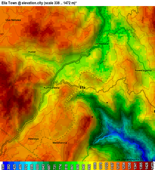
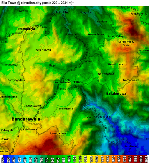
Below is the Elevation map of Ella Town, which displays elevation range with different colors. Scale of the first map is from 338 to 1472 m (1109 to 4829 ft) with average elevation of 1048.7 meters (=3441 ft) [note 1]
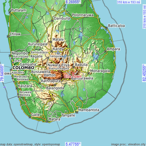
These maps also provides idea of topography and contour of this city, they are displayed at different zoom levels. More info about maps, scale and edge coordinates you can find below images.
| \ | Map #1 | Map #2 | Topo.Map |
| Scale [m] | 338..1472 m | 220..2031 m | × |
| Scale [ft] | 1109..4829 ft | 722..6663 ft | × |
| Average | 1048.7 m = 3441 ft | 1077 m = 3533 ft | × |
| Width | 9.7 km = 6 mi | 19.4 km = 12.1 mi | 310.4 km = 192.9 mi |
| Height | 9.7 km = 6 mi | 19.4 km = 12.1 mi | 310.5 km = 192.9 mi |
| ↑Max Latitude | 6.919227° | 6.962851° | 8.26955° |
| Latitude at center | 6.8756° | 6.8756° | 6.8756° |
| ↓Min Latitude | 6.831969° | 6.788333° | 5.47755° |
| ← Min Longitude | 81.002355° | 80.958409° | 79.64005° |
| Longitude center | 81.0463° | 81.0463° | 81.0463° |
| →Max Longitude | 81.090245° | 81.134191° | 82.45255° |
Nearby cities:
Cities around Ella Town sort by population:
• Kandy elevation 514 m
64.8 km,  315°
315°
• Badulla 774 m
11.7 km,  6°
6°
• Nuwara Eliya 1868 m
30.9 km,  289°
289°
• Gampola 492 m
61.6 km,  301°
301°
• Kataragama 48 m
60.5 km,  148°
148°
• Hatton 1309 m
49.8 km,  272°
272°
• Monaragala 151 m
33.4 km,  90°
90°
• Wellawaya 188 m
16.6 km,  157°
157°
• Wattegama 105 m
48.7 km,  100°
100°
• Haputale 1449 m
16.1 km,  220°
220°
• Talawakele 1217 m
43.4 km,  279°
279°
• Kadugannawa 580 m
71.4 km,  306°
306°
Multilingual:
 En español:
Ella Town elevación 1031 m.
 En France:
Ella Town élévation 1031 m.
 Auf Deutsch:
Ella Town höhe über dem Meeresspiegel ist 1031 m.

Sources and notes:
- [note 1] Map square and city borders are not equal. Map elevation data is calculated only from area inside that square.
- [src 1] Elevation data from geonames database provided with same terms of usage.
- [src 2] The elevation map of Ella Town is generated using elevation data from NASA's 3 arcsec (90m) resolution SRTM data.
- [src 3] Base (background) map © OpenStreetMap contributors tiles are generated by Geofabrik and OpenTopoMap.
Copyright & License:
This Ella Town Elevation Map is licensed under CC BY-SA. You may reuse any part from this page, if you give a proper credit by linking to this URL:
 More info on terms of use page.