Mauren elevation
Mauren, Liechtenstein elevation is 452 meters and Mauren elevation in feet is 1483 ft above sea level [src 1]. Mauren is a seat of a first-order administrative division (feature code) with elevation that is 90 meters (295 ft) smaller than average city elevation in Liechtenstein.
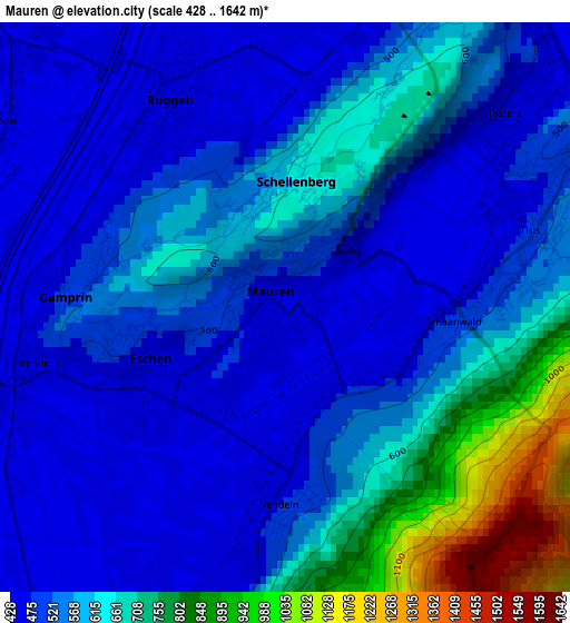
Below is the Elevation map of Mauren, which displays elevation range with different colors. Scale of the first map is from 428 to 1642 m (1404 to 5387 ft) with average elevation of 572.8 meters (=1879 ft) [note 1]
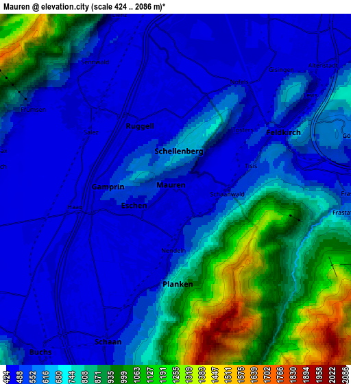
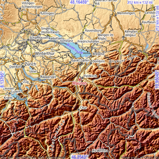
These maps also provides idea of topography and contour of this city, they are displayed at different zoom levels. More info about maps, scale and edge coordinates you can find below images.
| \ | Map #1 | Map #2 | Topo.Map |
| Scale [m] | 428..1642 m | 424..2086 m | × |
| Scale [ft] | 1404..5387 ft | 1391..6844 ft | × |
| Average | 572.8 m = 1879 ft | 674.8 m = 2214 ft | × |
| Width | 6.64 km = 4.1 mi | 13.28 km = 8.3 mi | 212.4 km = 132 mi |
| Height | 6.64 km = 4.1 mi | 13.28 km = 8.3 mi | 212.4 km = 132 mi |
| ↑Max Latitude | 47.24789° | 47.277713° | 48.16459° |
| Latitude at center | 47.21805° | 47.21805° | 47.21805° |
| ↓Min Latitude | 47.188193° | 47.15832° | 46.2543° |
| ← Min Longitude | 9.500255° | 9.456309° | 8.13795° |
| Longitude center | 9.5442° | 9.5442° | 9.5442° |
| →Max Longitude | 9.588145° | 9.632091° | 10.95045° |
Nearby cities:
Cities around Mauren sort by population:
• Schaan elevation 453 m
6.5 km,  204°
204°
• Vaduz 465 m
8.7 km,  191°
191°
• Triesen 500 m
12.3 km, 185°
• Balzers 476 m
17.1 km, 190°
• Eschen 446 m
1.8 km,  243°
243°
• Triesenberg 854 m
11.1 km,  180°
180°
• Ruggell 434 m
2.6 km,  327°
327°
• Gamprin 470 m
2.6 km,  275°
275°
• Schellenberg 631 m
1.5 km,  7°
7°
• Planken 785 m
3.7 km, 179°
Multilingual:
 En español:
Mauren elevación 452 m.
 En France:
Mauren élévation 452 m.


Sources and notes:
- [note 1] Map square and city borders are not equal. Map elevation data is calculated only from area inside that square.
- [src 1] Elevation data from geonames database provided with same terms of usage.
- [src 2] The elevation map of Mauren is generated using elevation data from NASA's 3 arcsec (90m) resolution SRTM data.
- [src 3] Base (background) map © OpenStreetMap contributors tiles are generated by Geofabrik and OpenTopoMap.
Copyright & License:
This Mauren Elevation Map is licensed under CC BY-SA. You may reuse any part from this page, if you give a proper credit by linking to this URL:
 More info on terms of use page.