Nabatîyé et Tahta elevation
Nabatîyé et Tahta (Nabatîyé), Lebanon elevation is 428 meters and Nabatîyé et Tahta elevation in feet is 1404 ft above sea level [src 1]. Nabatîyé et Tahta is a seat of a first-order administrative division (feature code) with elevation that is 127 meters (417 ft) smaller than average city elevation in Lebanon.
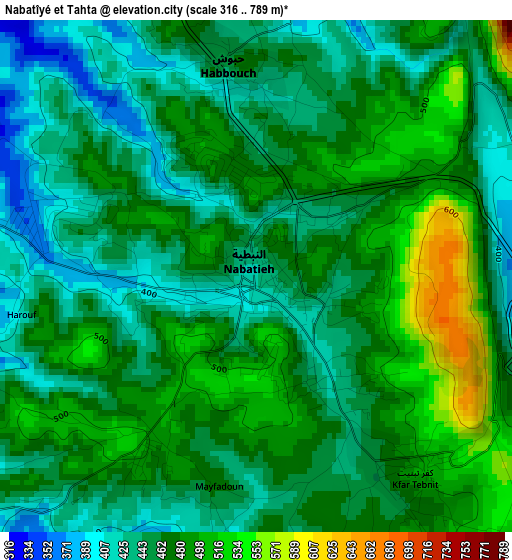
Below is the Elevation map of Nabatîyé et Tahta, which displays elevation range with different colors. Scale of the first map is from 316 to 789 m (1037 to 2589 ft) with average elevation of 463.9 meters (=1522 ft) [note 1]
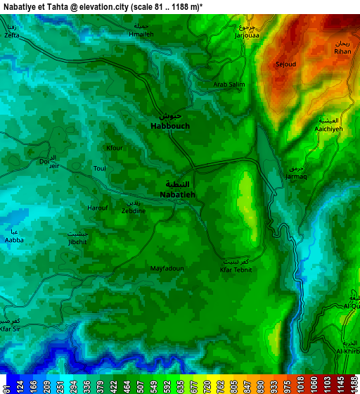
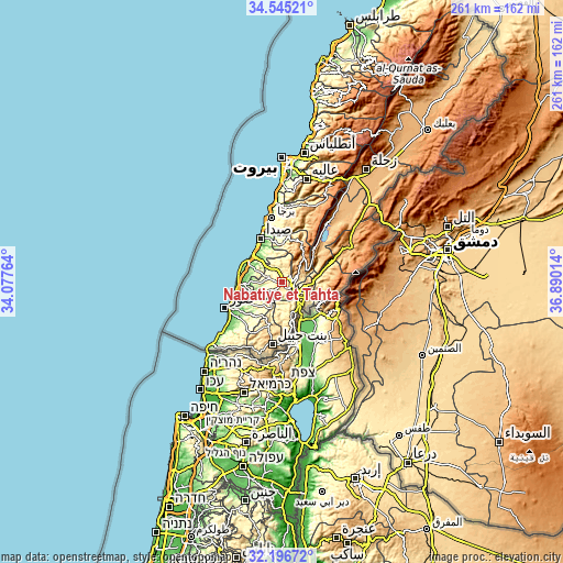
These maps also provides idea of topography and contour of this city, they are displayed at different zoom levels. More info about maps, scale and edge coordinates you can find below images.
| \ | Map #1 | Map #2 | Topo.Map |
| Scale [m] | 316..789 m | 81..1188 m | × |
| Scale [ft] | 1037..2589 ft | 266..3898 ft | × |
| Average | 463.9 m = 1522 ft | 457.3 m = 1500 ft | × |
| Width | 8.16 km = 5.1 mi | 16.32 km = 10.1 mi | 261.1 km = 162.2 mi |
| Height | 8.16 km = 5.1 mi | 16.32 km = 10.1 mi | 261.1 km = 162.2 mi |
| ↑Max Latitude | 33.415579° | 33.452252° | 34.54521° |
| Latitude at center | 33.37889° | 33.37889° | 33.37889° |
| ↓Min Latitude | 33.342186° | 33.305466° | 32.19672° |
| ← Min Longitude | 35.439945° | 35.395999° | 34.07764° |
| Longitude center | 35.48389° | 35.48389° | 35.48389° |
| →Max Longitude | 35.527835° | 35.571781° | 36.89014° |
Nearby cities:
Cities around Nabatîyé et Tahta sort by population:
• Sidon elevation 9 m
22.4 km,  332°
332°
• Tyre 7 m
29.4 km,  246°
246°
• Habboûch 457 m
3.2 km,  356°
356°
• En Nâqoûra 71 m
43.2 km,  227°
227°
• Ain Ebel 758 m
30.8 km,  194°
194°
• Joubb Jannîne 945 m
39.2 km,  45°
45°
• Beït ed Dîne 859 m
36.2 km,  14°
14°
• Râchaïya el Ouadi 1240 m
36 km,  67°
67°
• Bent Jbaïl 743 m
29.2 km, 189°
• Jezzîne 945 m
20.4 km,  27°
27°
• Hâsbaïya 747 m
18.8 km,  83°
83°
• Marjayoûn 731 m
10.2 km,  101°
101°
Multilingual:
 En español:
Nabatîyé et Tahta elevación 428 m.
 En France:
Nabatîyé et Tahta élévation 428 m.
 Auf Deutsch:
Nabatîyé et Tahta höhe über dem Meeresspiegel ist 428 m.

Sources and notes:
- [note 1] Map square and city borders are not equal. Map elevation data is calculated only from area inside that square.
- [src 1] Elevation data from geonames database provided with same terms of usage.
- [src 2] The elevation map of Nabatîyé et Tahta is generated using elevation data from NASA's 3 arcsec (90m) resolution SRTM data.
- [src 3] Base (background) map © OpenStreetMap contributors tiles are generated by Geofabrik and OpenTopoMap.
Copyright & License:
This Nabatîyé et Tahta Elevation Map is licensed under CC BY-SA. You may reuse any part from this page, if you give a proper credit by linking to this URL:
 More info on terms of use page.