Lamam elevation
Lamam (Xékong), Laos elevation is 199 meters and Lamam elevation in feet is 653 ft above sea level [src 1]. Lamam is a populated place (feature code) with elevation that is 275 meters (902 ft) smaller than average city elevation in Laos.
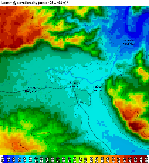
Below is the Elevation map of Lamam, which displays elevation range with different colors. Scale of the first map is from 128 to 498 m (420 to 1634 ft) with average elevation of 255 meters (=837 ft) [note 1]
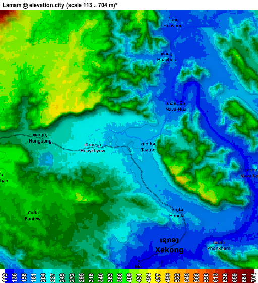
These maps also provides idea of topography and contour of this city, they are displayed at different zoom levels. More info about maps, scale and edge coordinates you can find below images.
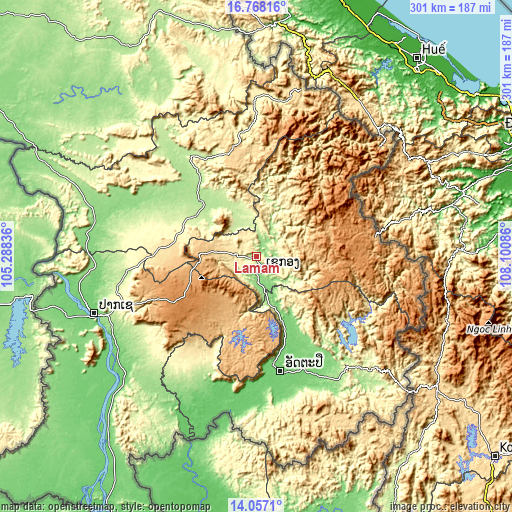
| \ | Map #1 | Map #2 | Topo.Map |
| Scale [m] | 128..498 m | 113..704 m | × |
| Scale [ft] | 420..1634 ft | 371..2310 ft | × |
| Average | 255 m = 837 ft | 268.8 m = 882 ft | × |
| Width | 9.42 km = 5.9 mi | 18.84 km = 11.7 mi | 301.4 km = 187.3 mi |
| Height | 9.42 km = 5.9 mi | 18.84 km = 11.7 mi | 301.5 km = 187.3 mi |
| ↑Max Latitude | 15.45941° | 15.501761° | 16.76816° |
| Latitude at center | 15.41705° | 15.41705° | 15.41705° |
| ↓Min Latitude | 15.374682° | 15.332305° | 14.0571° |
| ← Min Longitude | 106.650665° | 106.606719° | 105.28836° |
| Longitude center | 106.69461° | 106.69461° | 106.69461° |
| →Max Longitude | 106.738555° | 106.782501° | 108.10086° |
Nearby cities:
Cities around Lamam sort by population:
• Pakse elevation 105 m
101.6 km,  251°
251°
• Champasak 101 m
105.3 km,  236°
236°
• Salavan 183 m
44.6 km,  318°
318°
• Pakxong 1286 m
56.3 km, 242°
• Attapeu 100 m
69 km,  167°
167°
• Ban Thatèng 856 m
33.5 km,  273°
273°
• Ban Hatgnao 89 m
82.8 km,  188°
188°
• Sanaxy 906 m
74.9 km,  125°
125°
• Ban Fangdèng 106 m
71.9 km,  159°
159°
• Xaysetha 103 m
71.8 km, 158°
• Dak Cheung 1235 m
61.6 km,  84°
84°
• Sekong 148 m
8.5 km, 158°
Multilingual:
 En español:
Lamam elevación 199 m.
 En France:
Lamam élévation 199 m.


Sources and notes:
- [note 1] Map square and city borders are not equal. Map elevation data is calculated only from area inside that square.
- [src 1] Elevation data from geonames database provided with same terms of usage.
- [src 2] The elevation map of Lamam is generated using elevation data from NASA's 3 arcsec (90m) resolution SRTM data.
- [src 3] Base (background) map © OpenStreetMap contributors tiles are generated by Geofabrik and OpenTopoMap.
Copyright & License:
This Lamam Elevation Map is licensed under CC BY-SA. You may reuse any part from this page, if you give a proper credit by linking to this URL:
 More info on terms of use page.