Vangviang elevation
Vangviang (Vientiane), Laos elevation is 243 meters and Vangviang elevation in feet is 797 ft above sea level [src 1]. Vangviang is a populated place (feature code) with elevation that is 231 meters (758 ft) smaller than average city elevation in Laos.
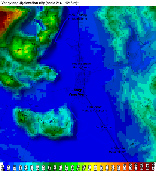
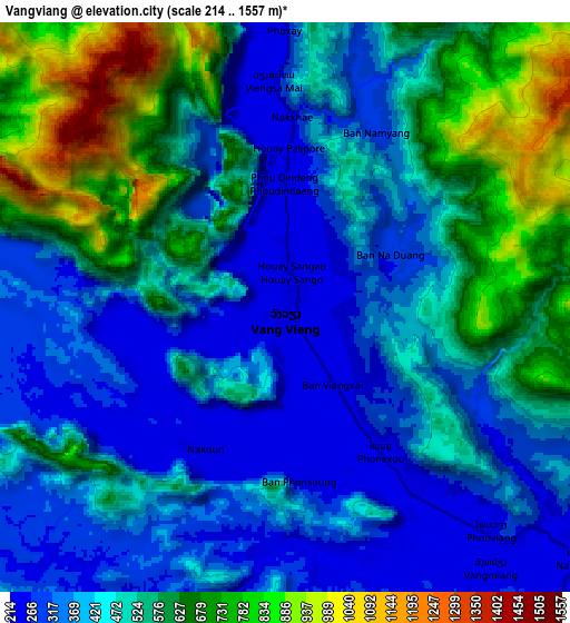
Below is the Elevation map of Vangviang, which displays elevation range with different colors. Scale of the first map is from 214 to 1213 m (702 to 3980 ft) with average elevation of 327.2 meters (=1073 ft) [note 1]
These maps also provides idea of topography and contour of this city, they are displayed at different zoom levels. More info about maps, scale and edge coordinates you can find below images.
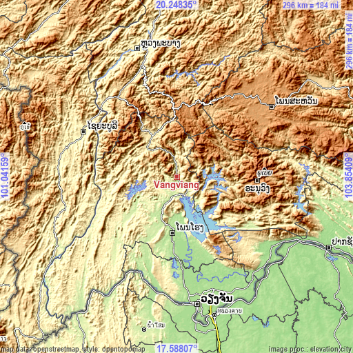
| \ | Map #1 | Map #2 | Topo.Map |
| Scale [m] | 214..1213 m | 214..1557 m | × |
| Scale [ft] | 702..3980 ft | 702..5108 ft | × |
| Average | 327.2 m = 1073 ft | 485.3 m = 1592 ft | × |
| Width | 9.24 km = 5.7 mi | 18.49 km = 11.5 mi | 295.8 km = 183.8 mi |
| Height | 9.24 km = 5.7 mi | 18.49 km = 11.5 mi | 295.8 km = 183.8 mi |
| ↑Max Latitude | 18.965065° | 19.00662° | 20.24835° |
| Latitude at center | 18.9235° | 18.9235° | 18.9235° |
| ↓Min Latitude | 18.881925° | 18.840339° | 17.58807° |
| ← Min Longitude | 102.403895° | 102.359949° | 101.04159° |
| Longitude center | 102.44784° | 102.44784° | 102.44784° |
| →Max Longitude | 102.491785° | 102.535731° | 103.85409° |
Nearby cities:
Cities around Vangviang sort by population:
• Vientiane elevation 174 m
107.6 km,  171°
171°
• Luang Prabang 300 m
111.9 km,  342°
342°
• Muang Phônsavan 1119 m
97.6 km,  53°
53°
• Pakxan 147 m
140.7 km,  114°
114°
• Sainyabuli 292 m
85.9 km,  295°
295°
• Muang Phôn-Hông 187 m
47.7 km,  184°
184°
• Muang Kènthao 242 m
172.6 km,  219°
219°
• Muang Mok 920 m
163.9 km,  90°
90°
• Borikhan 165 m
140.5 km, 106°
• Muang Sanakham 216 m
139.2 km, 215°
• Ban Xiang-Ngeun 318 m
96.9 km, 343°
• Muang Kasi 412 m
39.7 km,  328°
328°
Multilingual:
 En español:
Vangviang elevación 243 m.
 En France:
Vang Vieng élévation 243 m.
 Auf Deutsch:
Vangviang höhe über dem Meeresspiegel ist 243 m.

Sources and notes:
- [note 1] Map square and city borders are not equal. Map elevation data is calculated only from area inside that square.
- [src 1] Elevation data from geonames database provided with same terms of usage.
- [src 2] The elevation map of Vangviang is generated using elevation data from NASA's 3 arcsec (90m) resolution SRTM data.
- [src 3] Base (background) map © OpenStreetMap contributors tiles are generated by Geofabrik and OpenTopoMap.
Copyright & License:
This Vangviang Elevation Map is licensed under CC BY-SA. You may reuse any part from this page, if you give a proper credit by linking to this URL:
 More info on terms of use page.