Phôngsali elevation
Phôngsali, Laos elevation is 1344 meters and Phôngsali elevation in feet is 4409 ft above sea level [src 1]. Phôngsali is a seat of a first-order administrative division (feature code) with elevation that is 870 meters (2854 ft) bigger than average city elevation in Laos.
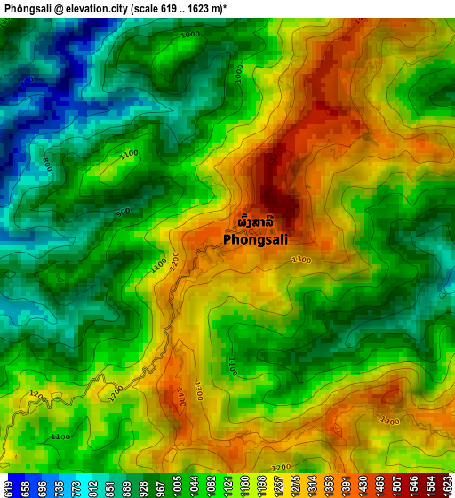
Below is the Elevation map of Phôngsali, which displays elevation range with different colors. Scale of the first map is from 619 to 1623 m (2031 to 5325 ft) with average elevation of 1102.8 meters (=3618 ft) [note 1]
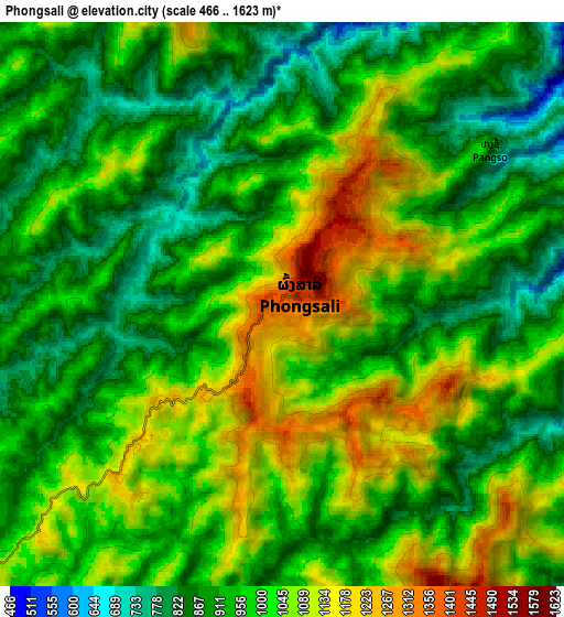
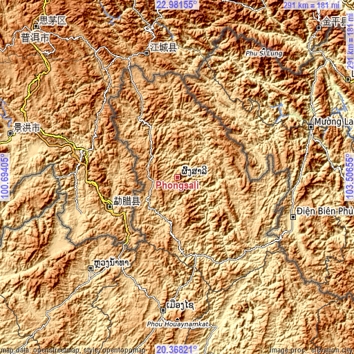
These maps also provides idea of topography and contour of this city, they are displayed at different zoom levels. More info about maps, scale and edge coordinates you can find below images.
| \ | Map #1 | Map #2 | Topo.Map |
| Scale [m] | 619..1623 m | 466..1623 m | × |
| Scale [ft] | 2031..5325 ft | 1529..5325 ft | × |
| Average | 1102.8 m = 3618 ft | 979.1 m = 3212 ft | × |
| Width | 9.08 km = 5.6 mi | 18.16 km = 11.3 mi | 290.6 km = 180.6 mi |
| Height | 9.08 km = 5.6 mi | 18.16 km = 11.3 mi | 290.6 km = 180.6 mi |
| ↑Max Latitude | 21.721631° | 21.76245° | 22.98155° |
| Latitude at center | 21.6808° | 21.6808° | 21.6808° |
| ↓Min Latitude | 21.639958° | 21.599104° | 20.36821° |
| ← Min Longitude | 102.056355° | 102.012409° | 100.69405° |
| Longitude center | 102.1003° | 102.1003° | 102.1003° |
| →Max Longitude | 102.144245° | 102.188191° | 103.50655° |
Nearby cities:
Cities around Phôngsali sort by population:
• Luang Prabang elevation 300 m
199.6 km,  178°
178°
• Muang Xay 652 m
110.6 km,  186°
186°
• Ban Houakhoua 361 m
233.8 km,  226°
226°
• Luang Namtha 551 m
108.9 km,  221°
221°
• Ban Xiang-Ngeun 318 m
213.9 km, 177°
• Viengthong 1313 m
202.7 km,  137°
137°
• Muang Long 502 m
154.6 km,  239°
239°
• Muang Nalè 482 m
144.6 km,  207°
207°
• Muang Sing 639 m
112.6 km, 241°
• Ban Pakla 472 m
90.2 km, 179°
• Ban Namnga 413 m
86 km,  131°
131°
• Khoa 394 m
79.1 km,  147°
147°
Multilingual:
 En español:
Phôngsali elevación 1344 m.
 En France:
Phôngsali élévation 1344 m.
 Auf Deutsch:
Phôngsali höhe über dem Meeresspiegel ist 1344 m.

Sources and notes:
- [note 1] Map square and city borders are not equal. Map elevation data is calculated only from area inside that square.
- [src 1] Elevation data from geonames database provided with same terms of usage.
- [src 2] The elevation map of Phôngsali is generated using elevation data from NASA's 3 arcsec (90m) resolution SRTM data.
- [src 3] Base (background) map © OpenStreetMap contributors tiles are generated by Geofabrik and OpenTopoMap.
Copyright & License:
This Phôngsali Elevation Map is licensed under CC BY-SA. You may reuse any part from this page, if you give a proper credit by linking to this URL:
 More info on terms of use page.