Bakanas elevation
Bakanas (Almaty Oblysy), Kazakhstan elevation is 395 meters and Bakanas elevation in feet is 1296 ft above sea level [src 1]. Bakanas is a populated place (feature code) with elevation that is 37 meters (121 ft) bigger than average city elevation in Kazakhstan.
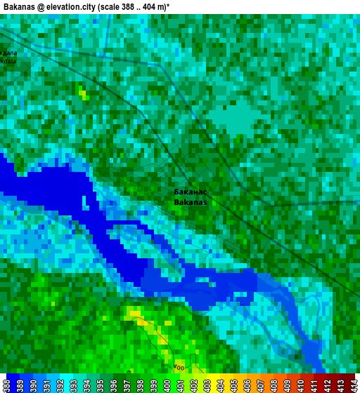
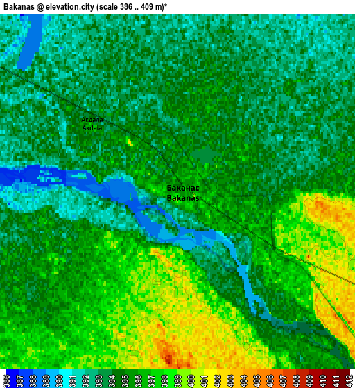
Below is the Elevation map of Bakanas, which displays elevation range with different colors. Scale of the first map is from 388 to 404 m (1273 to 1325 ft) with average elevation of 394.1 meters (=1293 ft) [note 1]
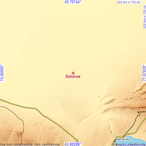
These maps also provides idea of topography and contour of this city, they are displayed at different zoom levels. More info about maps, scale and edge coordinates you can find below images.
| \ | Map #1 | Map #2 | Topo.Map |
| Scale [m] | 388..404 m | 386..409 m | × |
| Scale [ft] | 1273..1325 ft | 1266..1342 ft | × |
| Average | 394.1 m = 1293 ft | 394.7 m = 1295 ft | × |
| Width | 6.93 km = 4.3 mi | 13.87 km = 8.6 mi | 221.9 km = 137.9 mi |
| Height | 6.93 km = 4.3 mi | 13.87 km = 8.6 mi | 221.9 km = 137.9 mi |
| ↑Max Latitude | 44.839549° | 44.870702° | 45.79744° |
| Latitude at center | 44.80838° | 44.80838° | 44.80838° |
| ↓Min Latitude | 44.777194° | 44.745991° | 43.80206° |
| ← Min Longitude | 76.228195° | 76.184249° | 74.86589° |
| Longitude center | 76.27214° | 76.27214° | 76.27214° |
| →Max Longitude | 76.316085° | 76.360031° | 77.67839° |
Nearby cities:
Cities around Bakanas sort by population:
• Almaty elevation 787 m
180.3 km,  163°
163°
• Taldykorgan 596 m
167.1 km,  82°
82°
• Talghar 974 m
184.4 km, 155°
• Kapshagay 497 m
122.1 km,  149°
149°
• Burunday 689 m
168.1 km, 163°
• Ush-Tyube 430 m
143 km,  69°
69°
• Otegen Batyra 643 m
165.6 km, 158°
• Saryozek 932 m
143.5 km,  110°
110°
• Chemolgan 687 m
161.7 km,  169°
169°
• Balpyk Bī 584 m
154.8 km,  86°
86°
• Pervomayka 670 m
168.2 km, 161°
• Ülken 339 m
185.8 km,  283°
283°
Multilingual:
 En español:
Bakanas elevación 395 m.
 En France:
Bakanas élévation 395 m.


Sources and notes:
- [note 1] Map square and city borders are not equal. Map elevation data is calculated only from area inside that square.
- [src 1] Elevation data from geonames database provided with same terms of usage.
- [src 2] The elevation map of Bakanas is generated using elevation data from NASA's 3 arcsec (90m) resolution SRTM data.
- [src 3] Base (background) map © OpenStreetMap contributors tiles are generated by Geofabrik and OpenTopoMap.
Copyright & License:
This Bakanas Elevation Map is licensed under CC BY-SA. You may reuse any part from this page, if you give a proper credit by linking to this URL:
 More info on terms of use page.