Georgiyevka elevation
Georgiyevka (Zhambyl), Kazakhstan elevation is 624 meters and Georgiyevka elevation in feet is 2047 ft above sea level [src 1]. Georgiyevka is a populated place (feature code) with elevation that is 266 meters (873 ft) bigger than average city elevation in Kazakhstan.
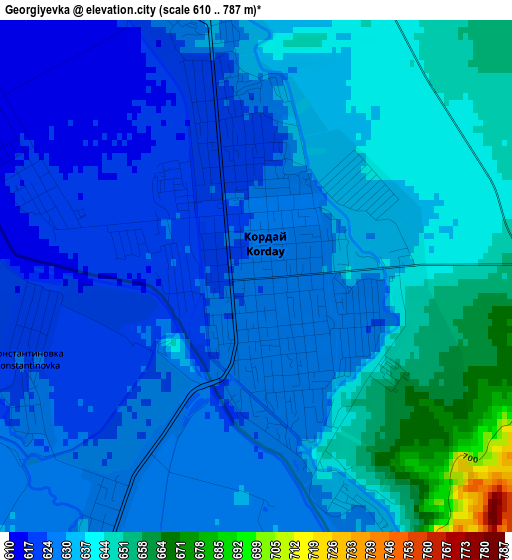
Below is the Elevation map of Georgiyevka, which displays elevation range with different colors. Scale of the first map is from 610 to 787 m (2001 to 2582 ft) with average elevation of 633.4 meters (=2078 ft) [note 1]
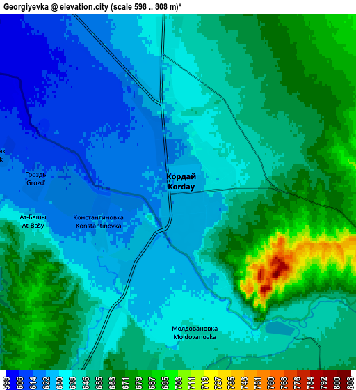
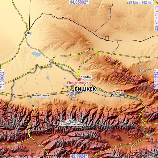
These maps also provides idea of topography and contour of this city, they are displayed at different zoom levels. More info about maps, scale and edge coordinates you can find below images.
| \ | Map #1 | Map #2 | Topo.Map |
| Scale [m] | 610..787 m | 598..808 m | × |
| Scale [ft] | 2001..2582 ft | 1962..2651 ft | × |
| Average | 633.4 m = 2078 ft | 644.5 m = 2115 ft | × |
| Width | 7.14 km = 4.4 mi | 14.29 km = 8.9 mi | 228.6 km = 142 mi |
| Height | 7.14 km = 4.4 mi | 14.29 km = 8.9 mi | 228.6 km = 142 mi |
| ↑Max Latitude | 43.070931° | 43.103025° | 44.05802° |
| Latitude at center | 43.03882° | 43.03882° | 43.03882° |
| ↓Min Latitude | 43.006692° | 42.974548° | 42.0024° |
| ← Min Longitude | 74.668925° | 74.624979° | 73.30662° |
| Longitude center | 74.71287° | 74.71287° | 74.71287° |
| →Max Longitude | 74.756815° | 74.800761° | 76.11912° |
Nearby cities:
Cities around Georgiyevka sort by population:
• Almaty elevation 787 m
181.4 km,  82°
82°
• Chu 470 m
99.5 km,  309°
309°
• Burunday 689 m
177.1 km, 78°
• Otegen Batyra 643 m
191.7 km, 77°
• Merke 700 m
125.8 km,  261°
261°
• Chemolgan 687 m
159.4 km, 76°
• Lugovoye 712 m
162.7 km, 264°
• Lugovoy 687 m
159.1 km,  266°
266°
• Oytal 675 m
118.3 km, 262°
• Pervomayka 670 m
184.3 km, 78°
• Granitogorsk 1059 m
106.5 km,  252°
252°
• Khantaū 548 m
151.4 km,  330°
330°
Multilingual:
 En español:
Georgiyevka elevación 624 m.
 En France:
Georgiyevka élévation 624 m.
 Auf Deutsch:
Georgiyevka höhe über dem Meeresspiegel ist 624 m.

Sources and notes:
- [note 1] Map square and city borders are not equal. Map elevation data is calculated only from area inside that square.
- [src 1] Elevation data from geonames database provided with same terms of usage.
- [src 2] The elevation map of Georgiyevka is generated using elevation data from NASA's 3 arcsec (90m) resolution SRTM data.
- [src 3] Base (background) map © OpenStreetMap contributors tiles are generated by Geofabrik and OpenTopoMap.
Copyright & License:
This Georgiyevka Elevation Map is licensed under CC BY-SA. You may reuse any part from this page, if you give a proper credit by linking to this URL:
 More info on terms of use page.