Komsomolets elevation
Komsomolets (Qostanay), Kazakhstan elevation is 190 meters and Komsomolets elevation in feet is 623 ft above sea level [src 1]. Komsomolets is a populated place (feature code) with elevation that is 168 meters (551 ft) smaller than average city elevation in Kazakhstan.
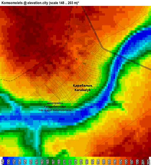
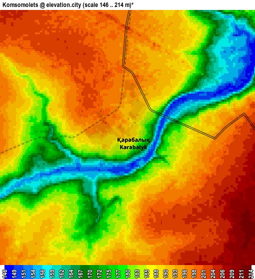
Below is the Elevation map of Komsomolets, which displays elevation range with different colors. Scale of the first map is from 148 to 203 m (486 to 666 ft) with average elevation of 182.5 meters (=599 ft) [note 1]
These maps also provides idea of topography and contour of this city, they are displayed at different zoom levels. More info about maps, scale and edge coordinates you can find below images.
| \ | Map #1 | Map #2 | Topo.Map |
| Scale [m] | 148..203 m | 146..214 m | × |
| Scale [ft] | 486..666 ft | 479..702 ft | × |
| Average | 182.5 m = 599 ft | 187.5 m = 615 ft | × |
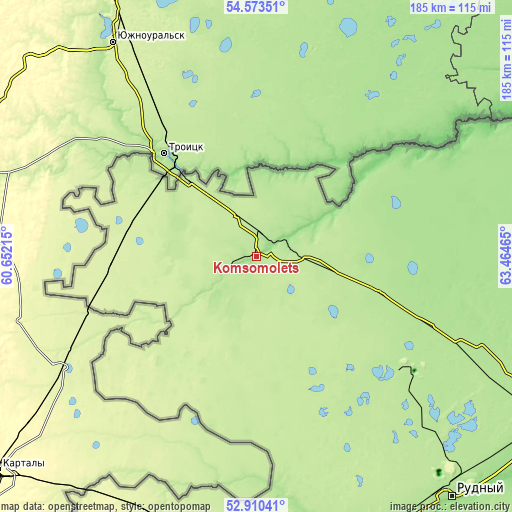
| Width | 5.78 km = 3.6 mi | 11.56 km = 7.2 mi | 184.9 km = 114.9 mi |
| Height | 5.78 km = 3.6 mi | 11.56 km = 7.2 mi | 184.9 km = 114.9 mi |
| ↑Max Latitude | 53.776167° | 53.802128° | 54.57351° |
| Latitude at center | 53.75019° | 53.75019° | 53.75019° |
| ↓Min Latitude | 53.724197° | 53.698188° | 52.91041° |
| ← Min Longitude | 62.014455° | 61.970509° | 60.65215° |
| Longitude center | 62.0584° | 62.0584° | 62.0584° |
| →Max Longitude | 62.102345° | 62.146291° | 63.46465° |
Nearby cities:
Cities around Komsomolets sort by population:
• Kostanay elevation 167 m
119.5 km,  119°
119°
• Rudnyy 167 m
111.4 km,  140°
140°
• Dzhetygara 271 m
182.8 km,  198°
198°
• Lisakovsk 192 m
137 km,  167°
167°
• Qashar 197 m
68.3 km,  128°
128°
• Borovskoy 175 m
139.7 km,  88°
88°
• Fyodorovka 196 m
43.8 km,  106°
106°
• Qusmuryn 114 m
223.8 km, 130°
• Tobol 207 m
122.7 km,  163°
163°
• Ordzhonikidze 228 m
146.3 km,  188°
188°
• Karasu 206 m
258.3 km, 117°
• Ayat 168 m
106.2 km, 163°
Multilingual:
 En español:
Komsomolets elevación 190 m.
 En France:
Komsomolets élévation 190 m.
 Auf Deutsch:
Komsomolets höhe über dem Meeresspiegel ist 190 m.

Sources and notes:
- [note 1] Map square and city borders are not equal. Map elevation data is calculated only from area inside that square.
- [src 1] Elevation data from geonames database provided with same terms of usage.
- [src 2] The elevation map of Komsomolets is generated using elevation data from NASA's 3 arcsec (90m) resolution SRTM data.
- [src 3] Base (background) map © OpenStreetMap contributors tiles are generated by Geofabrik and OpenTopoMap.
Copyright & License:
This Komsomolets Elevation Map is licensed under CC BY-SA. You may reuse any part from this page, if you give a proper credit by linking to this URL:
 More info on terms of use page.