Zharkent elevation
Zharkent (Almaty Oblysy), Kazakhstan elevation is 636 meters and Zharkent elevation in feet is 2087 ft above sea level [src 1]. Zharkent is a populated place (feature code) with elevation that is 278 meters (912 ft) bigger than average city elevation in Kazakhstan.
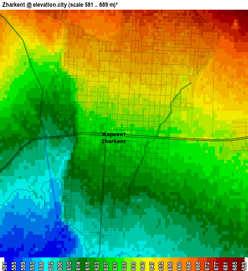
Below is the Elevation map of Zharkent, which displays elevation range with different colors. Scale of the first map is from 581 to 689 m (1906 to 2260 ft) with average elevation of 630.8 meters (=2070 ft) [note 1]
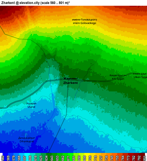
These maps also provides idea of topography and contour of this city, they are displayed at different zoom levels. More info about maps, scale and edge coordinates you can find below images.
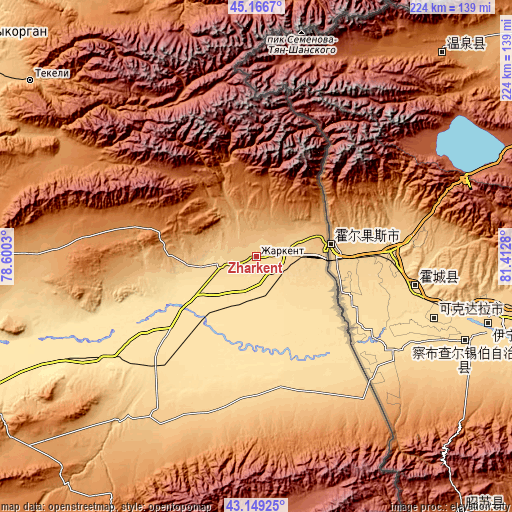
| \ | Map #1 | Map #2 | Topo.Map |
| Scale [m] | 581..689 m | 560..801 m | × |
| Scale [ft] | 1906..2260 ft | 1837..2628 ft | × |
| Average | 630.8 m = 2070 ft | 647.4 m = 2124 ft | × |
| Width | 7.01 km = 4.4 mi | 14.02 km = 8.7 mi | 224.3 km = 139.4 mi |
| Height | 7.01 km = 4.4 mi | 14.02 km = 8.7 mi | 224.3 km = 139.4 mi |
| ↑Max Latitude | 44.198114° | 44.229612° | 45.1667° |
| Latitude at center | 44.1666° | 44.1666° | 44.1666° |
| ↓Min Latitude | 44.135069° | 44.103521° | 43.14925° |
| ← Min Longitude | 79.962605° | 79.918659° | 78.6003° |
| Longitude center | 80.00655° | 80.00655° | 80.00655° |
| →Max Longitude | 80.050495° | 80.094441° | 81.4128° |
Nearby cities:
Cities around Zharkent sort by population:
• Taldykorgan elevation 596 m
160.1 km,  306°
306°
• Sarkand 772 m
138.6 km,  357°
357°
• Esik 1029 m
224.1 km,  246°
246°
• Tekeli 1146 m
119.1 km, 308°
• Ush-Tyube 430 m
200.5 km, 307°
• Saryozek 932 m
163.4 km,  277°
277°
• Turgen 971 m
211.6 km, 246°
• Balpyk Bī 584 m
162.7 km,  300°
300°
• Kegen 1847 m
142.2 km,  206°
206°
• Matay 412 m
217.2 km,  332°
332°
• Druzhba 424 m
229.8 km,  58°
58°
• Narynkol 1817 m
160.7 km,  175°
175°
Multilingual:
 En español:
Zharkent elevación 636 m.
 En France:
Zharkent élévation 636 m.
 Auf Deutsch:
Scharkent höhe über dem Meeresspiegel ist 636 m.

Sources and notes:
- [note 1] Map square and city borders are not equal. Map elevation data is calculated only from area inside that square.
- [src 1] Elevation data from geonames database provided with same terms of usage.
- [src 2] The elevation map of Zharkent is generated using elevation data from NASA's 3 arcsec (90m) resolution SRTM data.
- [src 3] Base (background) map © OpenStreetMap contributors tiles are generated by Geofabrik and OpenTopoMap.
Copyright & License:
This Zharkent Elevation Map is licensed under CC BY-SA. You may reuse any part from this page, if you give a proper credit by linking to this URL:
 More info on terms of use page.