Saryaghash elevation
Saryaghash (South Kazakhstan), Kazakhstan elevation is 441 meters and Saryaghash elevation in feet is 1447 ft above sea level [src 1]. Saryaghash is a populated place (feature code) with elevation that is 83 meters (272 ft) bigger than average city elevation in Kazakhstan.
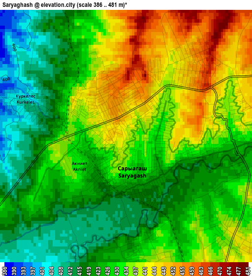
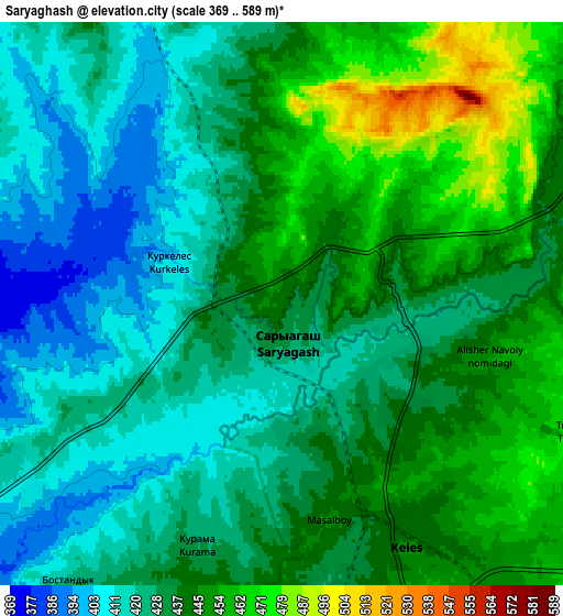
Below is the Elevation map of Saryaghash, which displays elevation range with different colors. Scale of the first map is from 386 to 481 m (1266 to 1578 ft) with average elevation of 429.8 meters (=1410 ft) [note 1]
These maps also provides idea of topography and contour of this city, they are displayed at different zoom levels. More info about maps, scale and edge coordinates you can find below images.
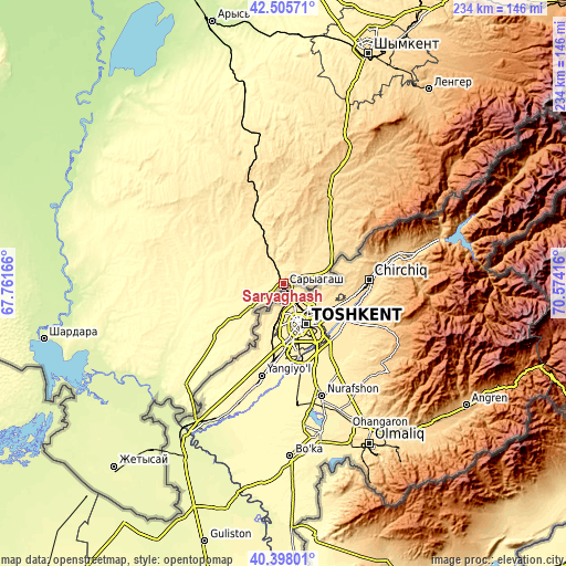
| \ | Map #1 | Map #2 | Topo.Map |
| Scale [m] | 386..481 m | 369..589 m | × |
| Scale [ft] | 1266..1578 ft | 1211..1932 ft | × |
| Average | 429.8 m = 1410 ft | 433.8 m = 1423 ft | × |
| Width | 7.32 km = 4.5 mi | 14.65 km = 9.1 mi | 234.4 km = 145.6 mi |
| Height | 7.32 km = 4.5 mi | 14.65 km = 9.1 mi | 234.3 km = 145.6 mi |
| ↑Max Latitude | 41.493345° | 41.526253° | 42.50571° |
| Latitude at center | 41.46042° | 41.46042° | 41.46042° |
| ↓Min Latitude | 41.427478° | 41.39452° | 40.39801° |
| ← Min Longitude | 69.123965° | 69.080019° | 67.76166° |
| Longitude center | 69.16791° | 69.16791° | 69.16791° |
| →Max Longitude | 69.211855° | 69.255801° | 70.57416° |
Nearby cities:
Cities around Saryaghash sort by population:
• Shymkent elevation 513 m
100 km,  20°
20°
• Arys 239 m
111.8 km,  344°
344°
• Belyye Vody 614 m
120 km,  27°
27°
• Chardara 255 m
102.5 km,  257°
257°
• Lenger 777 m
99.8 km,  36°
36°
• Leninskoye 585 m
37.5 km, 28°
• Atakent 263 m
87.8 km,  219°
219°
• Temirlanovka 291 m
126.9 km,  3°
3°
• Asyqata 265 m
92.1 km,  226°
226°
• Myrzakent 269 m
102.9 km,  210°
210°
• Sastobe 559 m
139.5 km, 29°
• Sayram 667 m
105.6 km, 27°
Multilingual:
 En español:
Saryaghash elevación 441 m.
 En France:
Saryaghash élévation 441 m.
 Auf Deutsch:
Saryaghash höhe über dem Meeresspiegel ist 441 m.
 На русском:
Сарыагаш, Сарыагач высота над уровнем моря 441 м
Sources and notes:
- [note 1] Map square and city borders are not equal. Map elevation data is calculated only from area inside that square.
- [src 1] Elevation data from geonames database provided with same terms of usage.
- [src 2] The elevation map of Saryaghash is generated using elevation data from NASA's 3 arcsec (90m) resolution SRTM data.
- [src 3] Base (background) map © OpenStreetMap contributors tiles are generated by Geofabrik and OpenTopoMap.
Copyright & License:
This Saryaghash Elevation Map is licensed under CC BY-SA. You may reuse any part from this page, if you give a proper credit by linking to this URL:
 More info on terms of use page.