Tyul’kubas elevation
Tyul’kubas (South Kazakhstan), Kazakhstan elevation is 823 meters and Tyul’kubas elevation in feet is 2700 ft above sea level [src 1]. Tyul’kubas is a populated place (feature code) with elevation that is 465 meters (1526 ft) bigger than average city elevation in Kazakhstan.
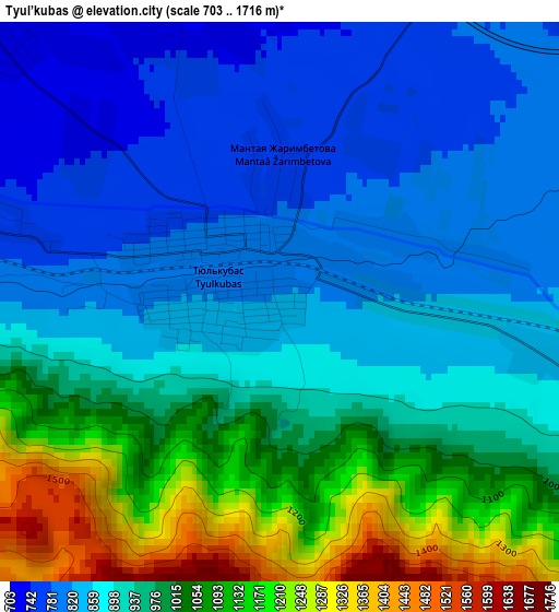
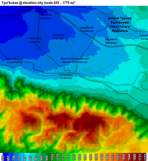
Below is the Elevation map of Tyul’kubas, which displays elevation range with different colors. Scale of the first map is from 703 to 1716 m (2306 to 5630 ft) with average elevation of 939.2 meters (=3081 ft) [note 1]
These maps also provides idea of topography and contour of this city, they are displayed at different zoom levels. More info about maps, scale and edge coordinates you can find below images.
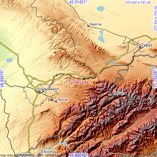
| \ | Map #1 | Map #2 | Topo.Map |
| Scale [m] | 703..1716 m | 639..1775 m | × |
| Scale [ft] | 2306..5630 ft | 2096..5823 ft | × |
| Average | 939.2 m = 3081 ft | 1002.6 m = 3289 ft | × |
| Width | 7.21 km = 4.5 mi | 14.41 km = 9 mi | 230.6 km = 143.3 mi |
| Height | 7.21 km = 4.5 mi | 14.41 km = 9 mi | 230.6 km = 143.3 mi |
| ↑Max Latitude | 42.518179° | 42.550561° | 43.51421° |
| Latitude at center | 42.48578° | 42.48578° | 42.48578° |
| ↓Min Latitude | 42.453364° | 42.420932° | 41.44016° |
| ← Min Longitude | 70.252065° | 70.208119° | 68.88976° |
| Longitude center | 70.29601° | 70.29601° | 70.29601° |
| →Max Longitude | 70.339955° | 70.383901° | 71.70226° |
Nearby cities:
Cities around Tyul’kubas sort by population:
• Shymkent elevation 513 m
60.8 km,  250°
250°
• Karatau 521 m
78.3 km,  10°
10°
• Belyye Vody 614 m
39.1 km,  259°
259°
• Lenger 777 m
47.8 km,  224°
224°
• Turar Ryskulov 770 m
6.9 km,  39°
39°
• Temirlanovka 291 m
85.9 km,  278°
278°
• Chayan 381 m
96.4 km,  309°
309°
• Sastobe 559 m
25.5 km,  287°
287°
• Bayzhansay 870 m
81.9 km,  337°
337°
• Kokterek 759 m
3.5 km, 285°
• Zhabagly 1122 m
15.9 km,  109°
109°
• Sayram 667 m
48.7 km, 245°
Multilingual:
 En español:
Tyul’kubas elevación 823 m.
 En France:
Tyul’kubas élévation 823 m.
 Auf Deutsch:
Tyul’kubas höhe über dem Meeresspiegel ist 823 m.

Sources and notes:
- [note 1] Map square and city borders are not equal. Map elevation data is calculated only from area inside that square.
- [src 1] Elevation data from geonames database provided with same terms of usage.
- [src 2] The elevation map of Tyul’kubas is generated using elevation data from NASA's 3 arcsec (90m) resolution SRTM data.
- [src 3] Base (background) map © OpenStreetMap contributors tiles are generated by Geofabrik and OpenTopoMap.
Copyright & License:
This Tyul’kubas Elevation Map is licensed under CC BY-SA. You may reuse any part from this page, if you give a proper credit by linking to this URL:
 More info on terms of use page.