Chingirlau elevation
Chingirlau (Batys Qazaqstan), Kazakhstan elevation is 109 meters and Chingirlau elevation in feet is 358 ft above sea level [src 1]. Chingirlau is a populated place (feature code) with elevation that is 249 meters (817 ft) smaller than average city elevation in Kazakhstan.
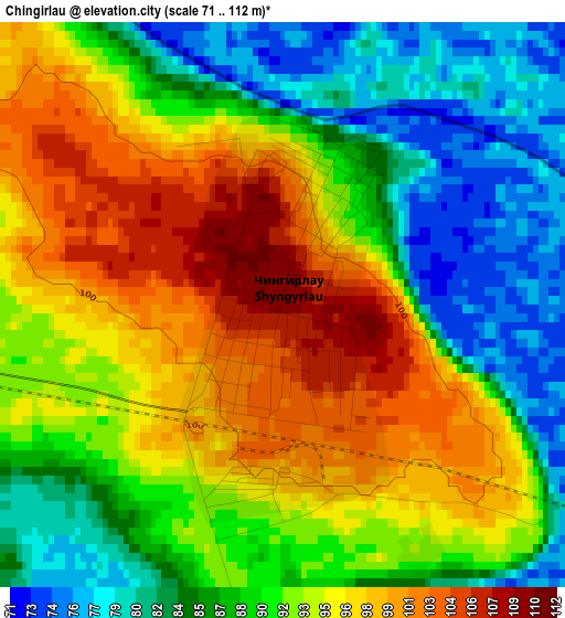
Below is the Elevation map of Chingirlau, which displays elevation range with different colors. Scale of the first map is from 71 to 112 m (233 to 367 ft) with average elevation of 91.4 meters (=300 ft) [note 1]
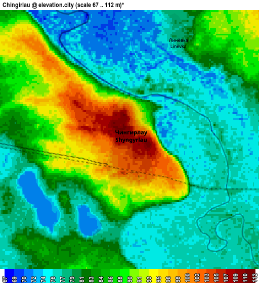
These maps also provides idea of topography and contour of this city, they are displayed at different zoom levels. More info about maps, scale and edge coordinates you can find below images.
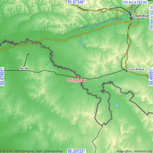
| \ | Map #1 | Map #2 | Topo.Map |
| Scale [m] | 71..112 m | 67..112 m | × |
| Scale [ft] | 233..367 ft | 220..367 ft | × |
| Average | 91.4 m = 300 ft | 82.6 m = 271 ft | × |
| Width | 6.14 km = 3.8 mi | 12.27 km = 7.6 mi | 196.4 km = 122 mi |
| Height | 6.14 km = 3.8 mi | 12.27 km = 7.6 mi | 196.4 km = 122 mi |
| ↑Max Latitude | 51.126369° | 51.153941° | 51.97346° |
| Latitude at center | 51.09878° | 51.09878° | 51.09878° |
| ↓Min Latitude | 51.071175° | 51.043554° | 50.20723° |
| ← Min Longitude | 54.040315° | 53.996369° | 52.67801° |
| Longitude center | 54.08426° | 54.08426° | 54.08426° |
| →Max Longitude | 54.128205° | 54.172151° | 55.49051° |
Nearby cities:
Cities around Chingirlau sort by population:
• Aktobe elevation 210 m
238.1 km,  112°
112°
• Oral 35 m
190.1 km,  274°
274°
• Aqsay 65 m
76.2 km,  275°
275°
• Martuk 176 m
174.2 km,  102°
102°
• Tasqala 69 m
264.6 km, 270°
• Dzhambeyty 30 m
140.4 km,  228°
228°
• Miyaly 33 m
247 km,  184°
184°
• Chapaev 7 m
228.7 km,  244°
244°
• Fedorovka 78 m
148.9 km, 275°
• Peremetnoe 50 m
225.5 km, 272°
• Burlin 50 m
102.1 km,  290°
290°
• Krūgloozernoe 28 m
195.2 km, 269°
Multilingual:
 En español:
Chingirlau elevación 109 m.
 En France:
Chingirlau élévation 109 m.
 Auf Deutsch:
Chingirlau höhe über dem Meeresspiegel ist 109 m.

Sources and notes:
- [note 1] Map square and city borders are not equal. Map elevation data is calculated only from area inside that square.
- [src 1] Elevation data from geonames database provided with same terms of usage.
- [src 2] The elevation map of Chingirlau is generated using elevation data from NASA's 3 arcsec (90m) resolution SRTM data.
- [src 3] Base (background) map © OpenStreetMap contributors tiles are generated by Geofabrik and OpenTopoMap.
Copyright & License:
This Chingirlau Elevation Map is licensed under CC BY-SA. You may reuse any part from this page, if you give a proper credit by linking to this URL:
 More info on terms of use page.