Kandyagash elevation
Kandyagash (Aqtöbe), Kazakhstan elevation is 294 meters and Kandyagash elevation in feet is 965 ft above sea level [src 1]. Kandyagash is a populated place (feature code) with elevation that is 64 meters (210 ft) smaller than average city elevation in Kazakhstan.
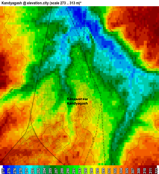
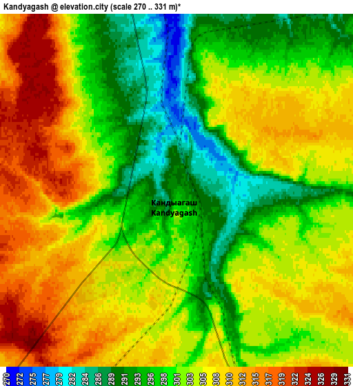
Below is the Elevation map of Kandyagash, which displays elevation range with different colors. Scale of the first map is from 273 to 313 m (896 to 1027 ft) with average elevation of 294 meters (=965 ft) [note 1]
These maps also provides idea of topography and contour of this city, they are displayed at different zoom levels. More info about maps, scale and edge coordinates you can find below images.
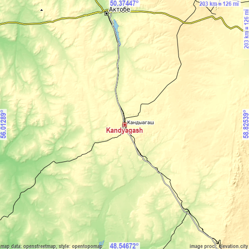
| \ | Map #1 | Map #2 | Topo.Map |
| Scale [m] | 273..313 m | 270..331 m | × |
| Scale [ft] | 896..1027 ft | 886..1086 ft | × |
| Average | 294 m = 965 ft | 302.6 m = 993 ft | × |
| Width | 6.35 km = 3.9 mi | 12.7 km = 7.9 mi | 203.2 km = 126.3 mi |
| Height | 6.35 km = 3.9 mi | 12.7 km = 7.9 mi | 203.2 km = 126.3 mi |
| ↑Max Latitude | 49.49767° | 49.526203° | 50.37447° |
| Latitude at center | 49.46912° | 49.46912° | 49.46912° |
| ↓Min Latitude | 49.440553° | 49.41197° | 48.54672° |
| ← Min Longitude | 57.375195° | 57.331249° | 56.01289° |
| Longitude center | 57.41914° | 57.41914° | 57.41914° |
| →Max Longitude | 57.463085° | 57.507031° | 58.82539° |
Nearby cities:
Cities around Kandyagash sort by population:
• Aktobe elevation 210 m
91.4 km,  350°
350°
• Shalqar 164 m
242.4 km,  138°
138°
• Khromtau 429 m
113.6 km,  40°
40°
• Embi 233 m
88.8 km, 143°
• Shubarkuduk 191 m
77 km,  241°
241°
• Shubarshi 183 m
100.3 km,  189°
189°
• Martuk 176 m
156.3 km,  335°
335°
• Bayganin 198 m
142 km,  232°
232°
• Miyaly 33 m
271.5 km,  256°
256°
• Batamshinskiy 426 m
135.9 km,  26°
26°
• Yrghyz 100 m
296 km,  108°
108°
• Temir 228 m
42.1 km,  210°
210°
Multilingual:
 En español:
Kandyagash elevación 294 m.
 En France:
Kandyagash élévation 294 m.
 Auf Deutsch:
Kandyagash höhe über dem Meeresspiegel ist 294 m.

Sources and notes:
- [note 1] Map square and city borders are not equal. Map elevation data is calculated only from area inside that square.
- [src 1] Elevation data from geonames database provided with same terms of usage.
- [src 2] The elevation map of Kandyagash is generated using elevation data from NASA's 3 arcsec (90m) resolution SRTM data.
- [src 3] Base (background) map © OpenStreetMap contributors tiles are generated by Geofabrik and OpenTopoMap.
Copyright & License:
This Kandyagash Elevation Map is licensed under CC BY-SA. You may reuse any part from this page, if you give a proper credit by linking to this URL:
 More info on terms of use page.