Shetpe elevation
Shetpe (Mangghystaū), Kazakhstan elevation is 209 meters and Shetpe elevation in feet is 686 ft above sea level [src 1]. Shetpe is a populated place (feature code) with elevation that is 149 meters (489 ft) smaller than average city elevation in Kazakhstan.
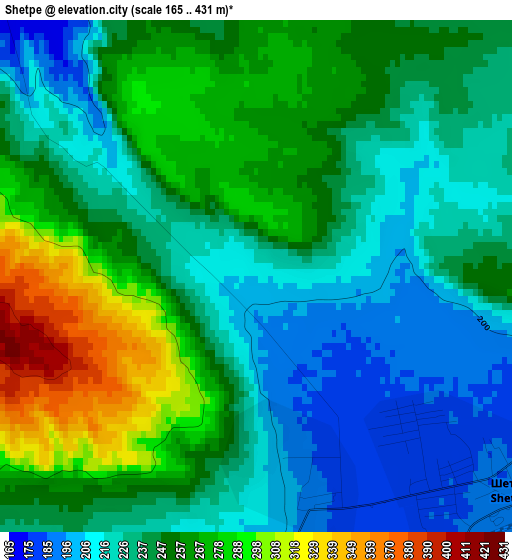
Below is the Elevation map of Shetpe, which displays elevation range with different colors. Scale of the first map is from 165 to 431 m (541 to 1414 ft) with average elevation of 244.5 meters (=802 ft) [note 1]
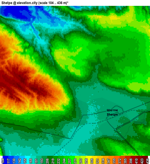
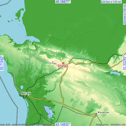
These maps also provides idea of topography and contour of this city, they are displayed at different zoom levels. More info about maps, scale and edge coordinates you can find below images.
| \ | Map #1 | Map #2 | Topo.Map |
| Scale [m] | 165..431 m | 104..436 m | × |
| Scale [ft] | 541..1414 ft | 341..1430 ft | × |
| Average | 244.5 m = 802 ft | 236.5 m = 776 ft | × |
| Width | 7.01 km = 4.4 mi | 14.02 km = 8.7 mi | 224.3 km = 139.4 mi |
| Height | 7.01 km = 4.4 mi | 14.02 km = 8.7 mi | 224.3 km = 139.4 mi |
| ↑Max Latitude | 44.198184° | 44.229682° | 45.16677° |
| Latitude at center | 44.16667° | 44.16667° | 44.16667° |
| ↓Min Latitude | 44.135139° | 44.103591° | 43.14932° |
| ← Min Longitude | 52.072725° | 52.028779° | 50.71042° |
| Longitude center | 52.11667° | 52.11667° | 52.11667° |
| →Max Longitude | 52.160615° | 52.204561° | 53.52292° |
Nearby cities:
Cities around Shetpe sort by population:
• Aktau elevation -5 m
95.3 km,  232°
232°
• Zhanaozen 204 m
109.6 km,  146°
146°
• Beyneu 6 m
275 km,  62°
62°
• Yeraliyev -11 m
115.1 km,  197°
197°
• Zhetibay 144 m
63.7 km,  182°
182°
• Qaraton -26 m
274 km,  23°
23°
• Fort-Shevchenko -17 m
152.1 km,  284°
284°
• Munayshy 129 m
75.1 km, 180°
• Baūtīno -22 m
154.5 km,  285°
285°
• Taūshyq 70 m
64.3 km, 288°
• Ömirzaq -25 m
94.4 km, 227°
• Sayötesh 228 m
114.2 km,  80°
80°
Multilingual:
 En español:
Shetpe elevación 209 m.
 En France:
Shetpe élévation 209 m.


Sources and notes:
- [note 1] Map square and city borders are not equal. Map elevation data is calculated only from area inside that square.
- [src 1] Elevation data from geonames database provided with same terms of usage.
- [src 2] The elevation map of Shetpe is generated using elevation data from NASA's 3 arcsec (90m) resolution SRTM data.
- [src 3] Base (background) map © OpenStreetMap contributors tiles are generated by Geofabrik and OpenTopoMap.
Copyright & License:
This Shetpe Elevation Map is licensed under CC BY-SA. You may reuse any part from this page, if you give a proper credit by linking to this URL:
 More info on terms of use page.