Ar Rumaythīyah elevation
Ar Rumaythīyah (Hawalli), Kuwait elevation is 9 meters and Ar Rumaythīyah elevation in feet is 30 ft above sea level [src 1]. Ar Rumaythīyah is a section of populated place (feature code) with elevation that is 18 meters (59 ft) smaller than average city elevation in Kuwait.
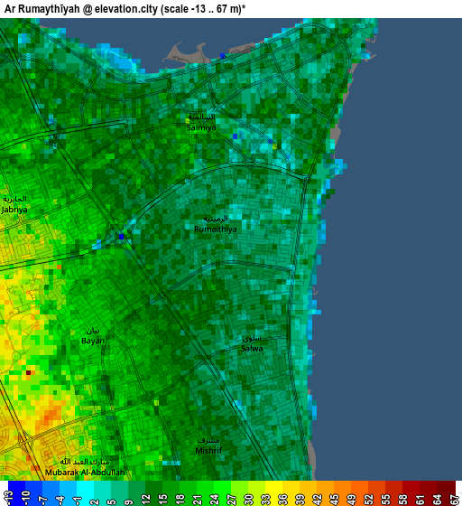
Below is the Elevation map of Ar Rumaythīyah, which displays elevation range with different colors. Scale of the first map is from -13 to 67 m (-43 to 220 ft) with average elevation of 15.1 meters (=50 ft) [note 1]
These maps also provides idea of topography and contour of this city, they are displayed at different zoom levels. More info about maps, scale and edge coordinates you can find below images.
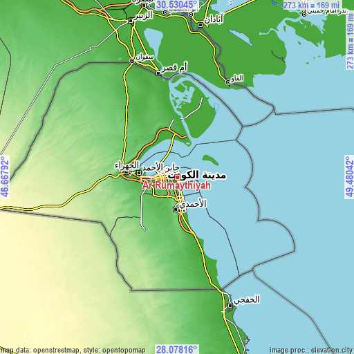
| \ | Map #1 | Map #2 | Topo.Map |
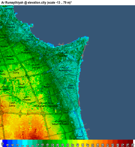
| Scale [m] | -13..67 m | -13..79 m | × |
| Scale [ft] | -43..220 ft | -43..259 ft | × |
| Average | 15.1 m = 50 ft | 25.3 m = 83 ft | × |
| Width | 8.52 km = 5.3 mi | 17.04 km = 10.6 mi | 272.7 km = 169.4 mi |
| Height | 8.52 km = 5.3 mi | 17.04 km = 10.6 mi | 272.7 km = 169.4 mi |
| ↑Max Latitude | 29.349982° | 29.388279° | 30.53045° |
| Latitude at center | 29.31167° | 29.31167° | 29.31167° |
| ↓Min Latitude | 29.273344° | 29.235003° | 28.07816° |
| ← Min Longitude | 48.030225° | 47.986279° | 46.66792° |
| Longitude center | 48.07417° | 48.07417° | 48.07417° |
| →Max Longitude | 48.118115° | 48.162061° | 49.48042° |
Nearby cities:
Cities around Ar Rumaythīyah sort by population:
• Ḩawallī elevation 19 m
5 km,  297°
297°
• As Sālimīyah 11 m
2.5 km,  4°
4°
• Şabāḩ as Sālim 32 m
6.3 km,  195°
195°
• Al Farwānīyah 44 m
11.8 km,  251°
251°
• Kuwait City 16 m
11.3 km, 304°
• Salwá 15 m
1.8 km,  166°
166°
• Bayān 20 m
2.6 km, 249°
• Janūb as Surrah 49 m
10.4 km,  243°
243°
• Ad Dasmah 9 m
9.2 km,  310°
310°
• Ash Shāmīyah 9 m
11.6 km,  289°
289°
• Al-Masayel 7 m
8.2 km, 170°
• Al Funayţīs 4 m
10 km,  164°
164°
Multilingual:
 En español:
Ar Rumaythīyah elevación 9 m.
 En France:
Ar Rumaythīyah élévation 9 m.
 Auf Deutsch:
Ar Rumaythīyah höhe über dem Meeresspiegel ist 9 m.

Sources and notes:
- [note 1] Map square and city borders are not equal. Map elevation data is calculated only from area inside that square.
- [src 1] Elevation data from geonames database provided with same terms of usage.
- [src 2] The elevation map of Ar Rumaythīyah is generated using elevation data from NASA's 3 arcsec (90m) resolution SRTM data.
- [src 3] Base (background) map © OpenStreetMap contributors tiles are generated by Geofabrik and OpenTopoMap.
Copyright & License:
This Ar Rumaythīyah Elevation Map is licensed under CC BY-SA. You may reuse any part from this page, if you give a proper credit by linking to this URL:
 More info on terms of use page.