Chuncheon elevation
Chuncheon (Gangwon-do), South Korea elevation is 92 meters and Chuncheon elevation in feet is 302 ft above sea level [src 1]. Chuncheon is a seat of a first-order administrative division (feature code) with elevation that is 20 meters (66 ft) bigger than average city elevation in South Korea.
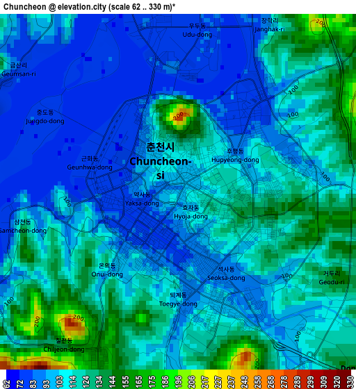
Below is the Elevation map of Chuncheon, which displays elevation range with different colors. Scale of the first map is from 62 to 330 m (203 to 1083 ft) with average elevation of 108.3 meters (=355 ft) [note 1]
These maps also provides idea of topography and contour of this city, they are displayed at different zoom levels. More info about maps, scale and edge coordinates you can find below images.
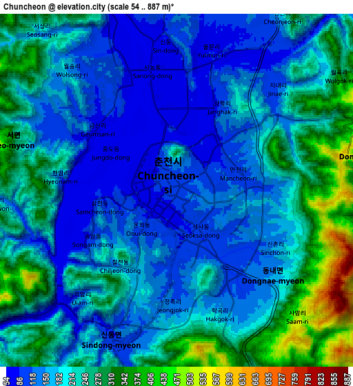
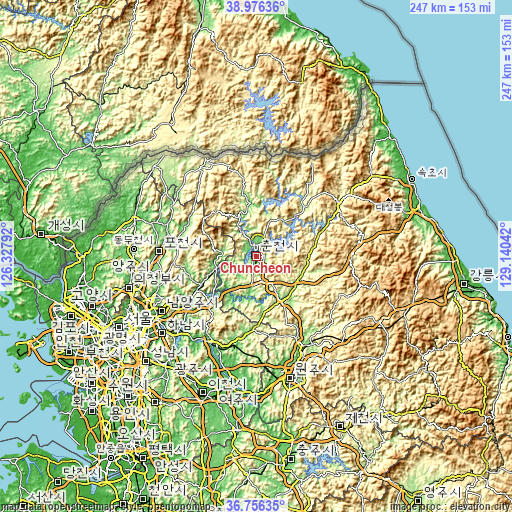
| \ | Map #1 | Map #2 | Topo.Map |
| Scale [m] | 62..330 m | 54..887 m | × |
| Scale [ft] | 203..1083 ft | 177..2910 ft | × |
| Average | 108.3 m = 355 ft | 201.5 m = 661 ft | × |
| Width | 7.71 km = 4.8 mi | 15.43 km = 9.6 mi | 246.8 km = 153.4 mi |
| Height | 7.71 km = 4.8 mi | 15.43 km = 9.6 mi | 246.8 km = 153.4 mi |
| ↑Max Latitude | 37.9094° | 37.944064° | 38.97636° |
| Latitude at center | 37.87472° | 37.87472° | 37.87472° |
| ↓Min Latitude | 37.840023° | 37.80531° | 36.75635° |
| ← Min Longitude | 127.690225° | 127.646279° | 126.32792° |
| Longitude center | 127.73417° | 127.73417° | 127.73417° |
| →Max Longitude | 127.778115° | 127.822061° | 129.14042° |
Nearby cities:
Cities around Chuncheon sort by population:
• Hwado elevation 86 m
44.9 km,  236°
236°
• Hongch’ŏn 137 m
24.3 km,  146°
146°
• Gapyeong 67 m
20.2 km,  256°
256°
• Yanggu 192 m
34.1 km,  41°
41°
• Hwacheon 115 m
25.9 km,  354°
354°
• Dongmyeon 293 m
45.3 km, 36°
• Seoseok 325 m
43.7 km,  114°
114°
• Bangsan 257 m
41.7 km,  26°
26°
• Su-dong 71 m
40.6 km, 242°
• Cheongpyeong 44 m
31.8 km, 240°
• Sindong 114 m
6.6 km,  193°
193°
• Dongnae 99 m
3.9 km,  141°
141°
Multilingual:
 En español:
Chuncheon elevación 92 m.
 En France:
Chuncheon élévation 92 m.
 Auf Deutsch:
Chuncheon höhe über dem Meeresspiegel ist 92 m.

Sources and notes:
- [note 1] Map square and city borders are not equal. Map elevation data is calculated only from area inside that square.
- [src 1] Elevation data from geonames database provided with same terms of usage.
- [src 2] The elevation map of Chuncheon is generated using elevation data from NASA's 3 arcsec (90m) resolution SRTM data.
- [src 3] Base (background) map © OpenStreetMap contributors tiles are generated by Geofabrik and OpenTopoMap.
Copyright & License:
This Chuncheon Elevation Map is licensed under CC BY-SA. You may reuse any part from this page, if you give a proper credit by linking to this URL:
 More info on terms of use page.