Imsil elevation
Imsil (Jeollabuk-do), South Korea elevation is 233 meters and Imsil elevation in feet is 764 ft above sea level [src 1]. Imsil is a seat of a third-order administrative division (feature code) with elevation that is 161 meters (528 ft) bigger than average city elevation in South Korea.
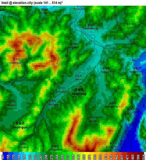
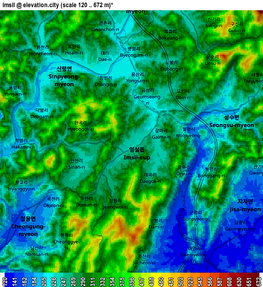
Below is the Elevation map of Imsil, which displays elevation range with different colors. Scale of the first map is from 141 to 514 m (463 to 1686 ft) with average elevation of 283.7 meters (=931 ft) [note 1]
These maps also provides idea of topography and contour of this city, they are displayed at different zoom levels. More info about maps, scale and edge coordinates you can find below images.
| \ | Map #1 | Map #2 | Topo.Map |
| Scale [m] | 141..514 m | 120..672 m | × |
| Scale [ft] | 463..1686 ft | 394..2205 ft | × |
| Average | 283.7 m = 931 ft | 273.8 m = 898 ft | × |
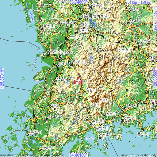
| Width | 7.94 km = 4.9 mi | 15.89 km = 9.9 mi | 254.2 km = 158 mi |
| Height | 7.94 km = 4.9 mi | 15.89 km = 9.9 mi | 254.2 km = 158 mi |
| ↑Max Latitude | 35.648778° | 35.68448° | 36.74809° |
| Latitude at center | 35.61306° | 35.61306° | 35.61306° |
| ↓Min Latitude | 35.577326° | 35.541576° | 34.46169° |
| ← Min Longitude | 127.235495° | 127.191549° | 125.87319° |
| Longitude center | 127.27944° | 127.27944° | 127.27944° |
| →Max Longitude | 127.323385° | 127.367331° | 128.68569° |
Nearby cities:
Cities around Imsil sort by population:
• Nangen elevation 103 m
24.5 km,  156°
156°
• Jinan-gun 295 m
23.8 km,  33°
33°
• Changsu 411 m
21.7 km,  79°
79°
• Ingye 137 m
25.6 km,  209°
209°
• Beonam 254 m
25.5 km,  110°
110°
• Gurim 195 m
23.9 km,  222°
222°
• Sannae 208 m
23.1 km,  257°
257°
• Donggye 94 m
19.3 km,  189°
189°
• Gangjin 136 m
13.9 km,  228°
228°
• Sanseo 153 m
11.1 km, 107°
• Gwanchon 212 m
6.9 km,  353°
353°
• Seongsu 192 m
5.3 km,  67°
67°
Multilingual:
 En español:
Imsil elevación 233 m.
 En France:
Imsil élévation 233 m.


Sources and notes:
- [note 1] Map square and city borders are not equal. Map elevation data is calculated only from area inside that square.
- [src 1] Elevation data from geonames database provided with same terms of usage.
- [src 2] The elevation map of Imsil is generated using elevation data from NASA's 3 arcsec (90m) resolution SRTM data.
- [src 3] Base (background) map © OpenStreetMap contributors tiles are generated by Geofabrik and OpenTopoMap.
Copyright & License:
This Imsil Elevation Map is licensed under CC BY-SA. You may reuse any part from this page, if you give a proper credit by linking to this URL:
 More info on terms of use page.