Koch'ang elevation
Koch'ang (Jeollabuk-do), South Korea elevation is 44 meters and Koch'ang elevation in feet is 144 ft above sea level [src 1]. Koch'ang is a populated place (feature code) with elevation that is 28 meters (92 ft) smaller than average city elevation in South Korea.
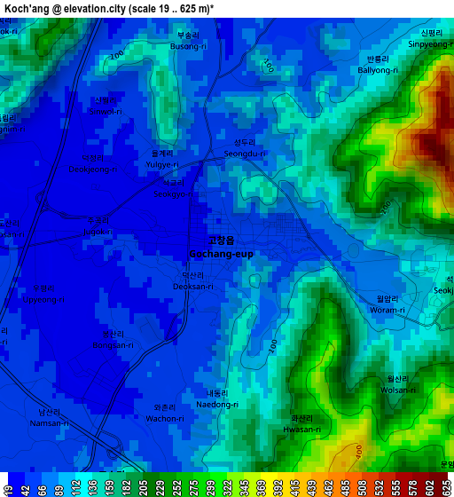
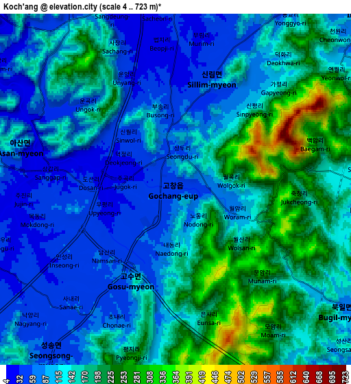
Below is the Elevation map of Koch'ang, which displays elevation range with different colors. Scale of the first map is from 19 to 625 m (62 to 2051 ft) with average elevation of 116 meters (=381 ft) [note 1]
These maps also provides idea of topography and contour of this city, they are displayed at different zoom levels. More info about maps, scale and edge coordinates you can find below images.
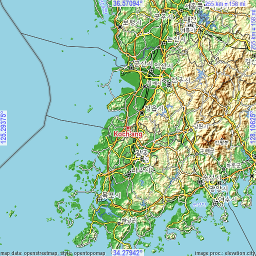
| \ | Map #1 | Map #2 | Topo.Map |
| Scale [m] | 19..625 m | 4..723 m | × |
| Scale [ft] | 62..2051 ft | 13..2372 ft | × |
| Average | 116 m = 381 ft | 137.3 m = 450 ft | × |
| Width | 7.96 km = 4.9 mi | 15.93 km = 9.9 mi | 254.8 km = 158.3 mi |
| Height | 7.96 km = 4.9 mi | 15.93 km = 9.9 mi | 254.8 km = 158.3 mi |
| ↑Max Latitude | 35.469128° | 35.504911° | 36.57094° |
| Latitude at center | 35.43333° | 35.43333° | 35.43333° |
| ↓Min Latitude | 35.397516° | 35.361686° | 34.27942° |
| ← Min Longitude | 126.656055° | 126.612109° | 125.29375° |
| Longitude center | 126.7° | 126.7° | 126.7° |
| →Max Longitude | 126.743945° | 126.787891° | 128.10625° |
Nearby cities:
Cities around Koch'ang sort by population:
• Jeongeup elevation 53 m
27 km,  46°
46°
• Yeonggwang 36 m
24.3 km,  224°
224°
• Beopseong 13 m
24.3 km,  251°
251°
• Myoryang 33 m
24.2 km, 216°
• Hongnong 21 m
23.5 km,  259°
259°
• Sangha 16 m
18.6 km,  273°
273°
• Daema 27 m
18.4 km, 217°
• Gongeum 16 m
18.2 km, 250°
• Simwon 17 m
16.9 km,  306°
306°
• Jangseong 70 m
16.9 km,  153°
153°
• Haeri 6 m
14.9 km,  282°
282°
• Daesan 36 m
13.4 km, 220°
Multilingual:
 En español:
Koch'ang elevación 44 m.
 En France:
Koch'ang élévation 44 m.


Sources and notes:
- [note 1] Map square and city borders are not equal. Map elevation data is calculated only from area inside that square.
- [src 1] Elevation data from geonames database provided with same terms of usage.
- [src 2] The elevation map of Koch'ang is generated using elevation data from NASA's 3 arcsec (90m) resolution SRTM data.
- [src 3] Base (background) map © OpenStreetMap contributors tiles are generated by Geofabrik and OpenTopoMap.
Copyright & License:
This Koch'ang Elevation Map is licensed under CC BY-SA. You may reuse any part from this page, if you give a proper credit by linking to this URL:
 More info on terms of use page.