Simcheon elevation
Simcheon (North Chungcheong), South Korea elevation is 93 meters and Simcheon elevation in feet is 305 ft above sea level [src 1]. Simcheon is a seat of a third-order administrative division (feature code) with elevation that is 21 meters (69 ft) bigger than average city elevation in South Korea.
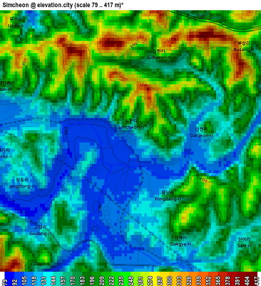
Below is the Elevation map of Simcheon, which displays elevation range with different colors. Scale of the first map is from 79 to 417 m (259 to 1368 ft) with average elevation of 179.9 meters (=590 ft) [note 1]
These maps also provides idea of topography and contour of this city, they are displayed at different zoom levels. More info about maps, scale and edge coordinates you can find below images.
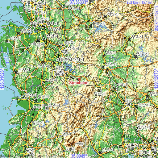
| \ | Map #1 | Topo.Map |
| Scale [m] | 79..417 m | × |
| Scale [ft] | 259..1368 ft | × |
| Average | 179.9 m = 590 ft | × |
| Width | 7.88 km = 4.9 mi | 252.2 km = 156.7 mi |
| Height | 7.88 km = 4.9 mi | 252.2 km = 156.7 mi |
| ↑Max Latitude | 36.272777° | 37.36333° |
| Latitude at center | 36.23734° | 36.23734° |
| ↓Min Latitude | 36.201887° | 35.0949° |
| ← Min Longitude | 127.678535° | 126.31623° |
| Longitude center | 127.72248° | 127.72248° |
| →Max Longitude | 127.766425° | 129.12873° |
Nearby cities:
Cities around Simcheon sort by population:
• Okcheon elevation 97 m
15.6 km,  297°
297°
• Yeongdong 130 m
8.5 km,  145°
145°
• Annae 87 m
18.3 km,  342°
342°
• Gunseo 112 m
18.1 km,  284°
284°
• Samseung 158 m
17.8 km,  2°
2°
• Hwanggan 163 m
16.7 km,  91°
91°
• Annam 86 m
14 km, 341°
• Cheongsan 108 m
13.7 km,  27°
27°
• Dongi 107 m
10.6 km, 299°
• Cheongseong 107 m
10.5 km,  18°
18°
• Yongsan 151 m
9.8 km,  74°
74°
• Iwon 113 m
9.3 km, 276°
Multilingual:
 En español:
Simcheon elevación 93 m.
 En France:
Simcheon élévation 93 m.


Sources and notes:
- [note 1] Map square and city borders are not equal. Map elevation data is calculated only from area inside that square.
- [src 1] Elevation data from geonames database provided with same terms of usage.
- [src 2] The elevation map of Simcheon is generated using elevation data from NASA's 3 arcsec (90m) resolution SRTM data.
- [src 3] Base (background) map © OpenStreetMap contributors tiles are generated by Geofabrik and OpenTopoMap.
Copyright & License:
This Simcheon Elevation Map is licensed under CC BY-SA. You may reuse any part from this page, if you give a proper credit by linking to this URL:
 More info on terms of use page.