Chasŏng elevation
Chasŏng (Chagang-do), North Korea elevation is 328 meters and Chasŏng elevation in feet is 1076 ft above sea level [src 1]. Chasŏng is a populated place (feature code) with elevation that is 197 meters (646 ft) bigger than average city elevation in North Korea.
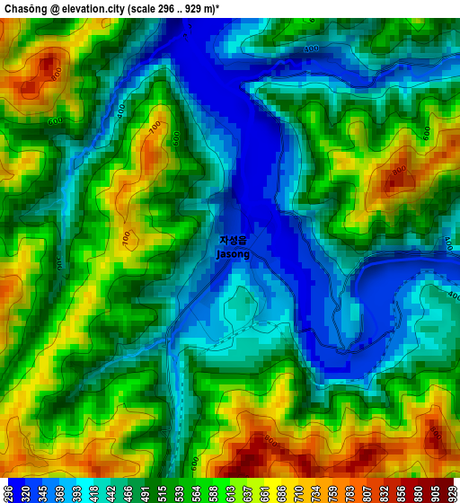
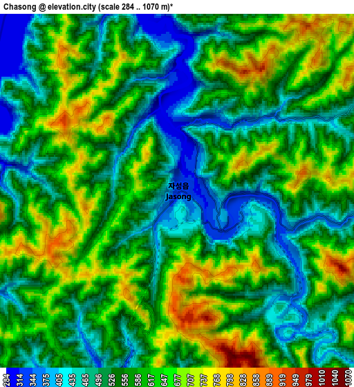
Below is the Elevation map of Chasŏng, which displays elevation range with different colors. Scale of the first map is from 296 to 929 m (971 to 3048 ft) with average elevation of 521.5 meters (=1711 ft) [note 1]
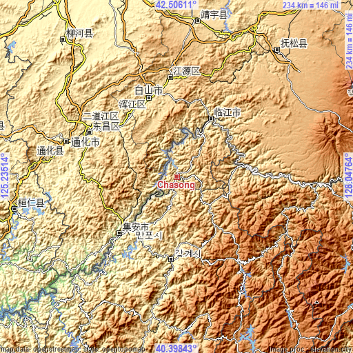
These maps also provides idea of topography and contour of this city, they are displayed at different zoom levels. More info about maps, scale and edge coordinates you can find below images.
| \ | Map #1 | Map #2 | Topo.Map |
| Scale [m] | 296..929 m | 284..1070 m | × |
| Scale [ft] | 971..3048 ft | 932..3510 ft | × |
| Average | 521.5 m = 1711 ft | 571.2 m = 1874 ft | × |
| Width | 7.32 km = 4.5 mi | 14.65 km = 9.1 mi | 234.4 km = 145.6 mi |
| Height | 7.32 km = 4.5 mi | 14.65 km = 9.1 mi | 234.3 km = 145.6 mi |
| ↑Max Latitude | 41.493755° | 41.526663° | 42.50611° |
| Latitude at center | 41.46083° | 41.46083° | 41.46083° |
| ↓Min Latitude | 41.427889° | 41.394931° | 40.39843° |
| ← Min Longitude | 126.597445° | 126.553499° | 125.23514° |
| Longitude center | 126.64139° | 126.64139° | 126.64139° |
| →Max Longitude | 126.685335° | 126.729281° | 128.04764° |
Nearby cities:
Cities around Chasŏng sort by population:
• Kanggye elevation 288 m
54.8 km,  184°
184°
• Hyesan 709 m
128.2 km,  92°
92°
• Manp’o 206 m
45 km,  220°
220°
• Hyesan-dong 736 m
128.4 km, 93°
• Yŏnggwang-ŭp 35 m
174.4 km,  156°
156°
• Kapsan-ŭp 813 m
144.1 km,  106°
106°
• Kujang-ŭp 66 m
184.5 km,  196°
196°
• Sakchu-ŭp 138 m
179.3 km,  228°
228°
• Pukchil-lodongjagu 210 m
158.9 km,  208°
208°
• Sŭngjibaegam 1466 m
181.7 km,  97°
97°
• Ŭijin-dong 296 m
55.4 km,  192°
192°
• Hŭngju-dong 297 m
52.2 km, 188°
Multilingual:
 En español:
Chasŏng elevación 328 m.
 En France:
Chasŏng élévation 328 m.


Sources and notes:
- [note 1] Map square and city borders are not equal. Map elevation data is calculated only from area inside that square.
- [src 1] Elevation data from geonames database provided with same terms of usage.
- [src 2] The elevation map of Chasŏng is generated using elevation data from NASA's 3 arcsec (90m) resolution SRTM data.
- [src 3] Base (background) map © OpenStreetMap contributors tiles are generated by Geofabrik and OpenTopoMap.
Copyright & License:
This Chasŏng Elevation Map is licensed under CC BY-SA. You may reuse any part from this page, if you give a proper credit by linking to this URL:
 More info on terms of use page.