Hoeryŏng elevation
Hoeryŏng (Hamgyŏng-bukto), North Korea elevation is 217 meters and Hoeryŏng elevation in feet is 712 ft above sea level [src 1]. Hoeryŏng is a seat of a second-order administrative division (feature code) with elevation that is 86 meters (282 ft) bigger than average city elevation in North Korea.
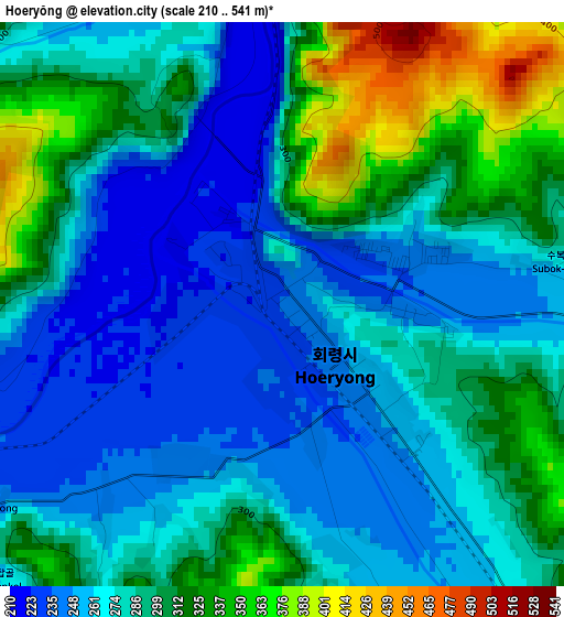
Below is the Elevation map of Hoeryŏng, which displays elevation range with different colors. Scale of the first map is from 210 to 541 m (689 to 1775 ft) with average elevation of 284.9 meters (=935 ft) [note 1]
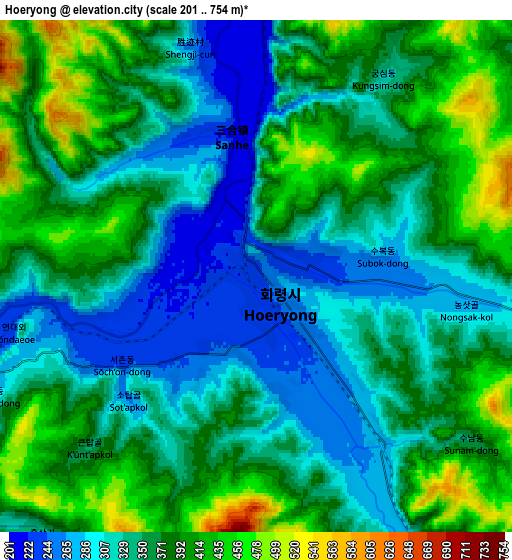
These maps also provides idea of topography and contour of this city, they are displayed at different zoom levels. More info about maps, scale and edge coordinates you can find below images.
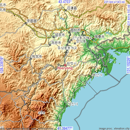
| \ | Map #1 | Map #2 | Topo.Map |
| Scale [m] | 210..541 m | 201..754 m | × |
| Scale [ft] | 689..1775 ft | 659..2474 ft | × |
| Average | 284.9 m = 935 ft | 358.1 m = 1175 ft | × |
| Width | 7.21 km = 4.5 mi | 14.42 km = 9 mi | 230.8 km = 143.4 mi |
| Height | 7.21 km = 4.5 mi | 14.42 km = 9 mi | 230.8 km = 143.4 mi |
| ↑Max Latitude | 42.473552° | 42.505957° | 43.4703° |
| Latitude at center | 42.44113° | 42.44113° | 42.44113° |
| ↓Min Latitude | 42.408691° | 42.376236° | 41.39477° |
| ← Min Longitude | 129.702065° | 129.658119° | 128.33976° |
| Longitude center | 129.74601° | 129.74601° | 129.74601° |
| →Max Longitude | 129.789955° | 129.833901° | 131.15226° |
Nearby cities:
Cities around Hoeryŏng sort by population:
• Rajin elevation 68 m
48.7 km,  115°
115°
• Aoji 30 m
54.2 km,  80°
80°
• Sŏnbong 20 m
53.3 km,  100°
100°
• Namyang-dong 281 m
57.4 km,  9°
9°
• Musan-ŭp 478 m
50.3 km,  241°
241°
• Kyŏngwŏn 83 m
53.1 km,  38°
38°
• Puryŏng 168 m
42.4 km,  183°
183°
• Komusan Il-tong 221 m
37.1 km,  185°
185°
• Ŭndŏk 47 m
49 km, 79°
• Chungbong 349 m
18.9 km, 36°
• Sech’ŏn 375 m
16.9 km,  26°
26°
• Sŏng-dong 326 m
10.2 km, 238°
Multilingual:
 En español:
Hoeryŏng elevación 217 m.
 En France:
Hoeryŏng élévation 217 m.
 Auf Deutsch:
Hoeryŏng höhe über dem Meeresspiegel ist 217 m.

Sources and notes:
- [note 1] Map square and city borders are not equal. Map elevation data is calculated only from area inside that square.
- [src 1] Elevation data from geonames database provided with same terms of usage.
- [src 2] The elevation map of Hoeryŏng is generated using elevation data from NASA's 3 arcsec (90m) resolution SRTM data.
- [src 3] Base (background) map © OpenStreetMap contributors tiles are generated by Geofabrik and OpenTopoMap.
Copyright & License:
This Hoeryŏng Elevation Map is licensed under CC BY-SA. You may reuse any part from this page, if you give a proper credit by linking to this URL:
 More info on terms of use page.