Kaesŏng elevation
Kaesŏng (Hwanghae-namdo), North Korea elevation is 42 meters and Kaesŏng elevation in feet is 138 ft above sea level [src 1]. Kaesŏng is a seat of a second-order administrative division (feature code) with elevation that is 89 meters (292 ft) smaller than average city elevation in North Korea.
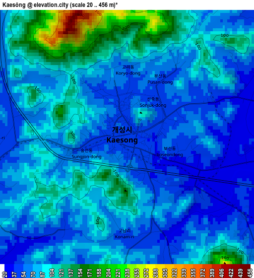
Below is the Elevation map of Kaesŏng, which displays elevation range with different colors. Scale of the first map is from 20 to 456 m (66 to 1496 ft) with average elevation of 82.9 meters (=272 ft) [note 1]
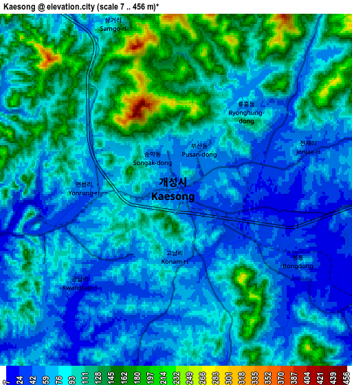
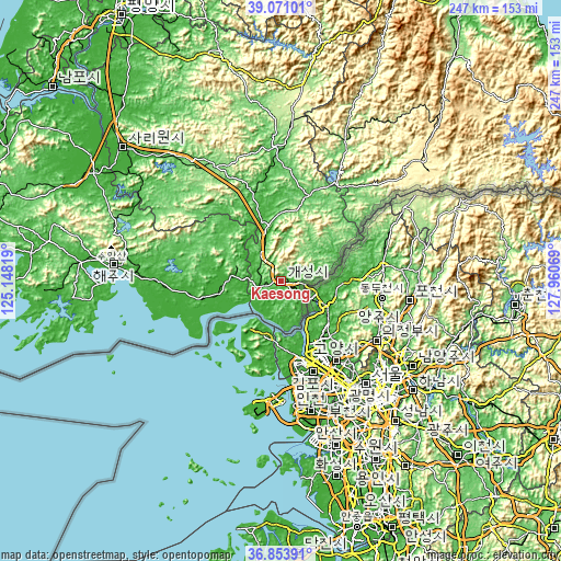
These maps also provides idea of topography and contour of this city, they are displayed at different zoom levels. More info about maps, scale and edge coordinates you can find below images.
| \ | Map #1 | Map #2 | Topo.Map |
| Scale [m] | 20..456 m | 7..456 m | × |
| Scale [ft] | 66..1496 ft | 23..1496 ft | × |
| Average | 82.9 m = 272 ft | 90.9 m = 298 ft | × |
| Width | 7.7 km = 4.8 mi | 15.41 km = 9.6 mi | 246.5 km = 153.2 mi |
| Height | 7.7 km = 4.8 mi | 15.41 km = 9.6 mi | 246.5 km = 153.2 mi |
| ↑Max Latitude | 38.005465° | 38.040084° | 39.07101° |
| Latitude at center | 37.97083° | 37.97083° | 37.97083° |
| ↓Min Latitude | 37.936179° | 37.901511° | 36.85391° |
| ← Min Longitude | 126.510495° | 126.466549° | 125.14819° |
| Longitude center | 126.55444° | 126.55444° | 126.55444° |
| →Max Longitude | 126.598385° | 126.642331° | 127.96069° |
Nearby cities:
Cities around Kaesŏng sort by population:
• Sariwŏn elevation 20 m
91.8 km,  310°
310°
• Haeju 57 m
74 km,  276°
276°
• Ongjin 19 m
104.6 km,  267°
267°
• Chaeryŏng-ŭp 17 m
94.9 km,  300°
300°
• Hwangju-ŭp 23 m
103.2 km,  318°
318°
• Hŭkkyo-ri 18 m
113.5 km, 324°
• Yŏnan-ŭp 43 m
35.2 km,  258°
258°
• Anak 28 m
110.4 km, 302°
• Sinmak 110 m
57 km,  330°
330°
• Ayang-ni 107 m
74.2 km,  294°
294°
• Pyŏksŏng-ŭp 12 m
87.8 km, 275°
• Koksan 165 m
90.7 km,  6°
6°
Multilingual:
 En español:
Kaesong elevación 42 m.
 En France:
Kaesong élévation 42 m.


Sources and notes:
- [note 1] Map square and city borders are not equal. Map elevation data is calculated only from area inside that square.
- [src 1] Elevation data from geonames database provided with same terms of usage.
- [src 2] The elevation map of Kaesŏng is generated using elevation data from NASA's 3 arcsec (90m) resolution SRTM data.
- [src 3] Base (background) map © OpenStreetMap contributors tiles are generated by Geofabrik and OpenTopoMap.
Copyright & License:
This Kaesŏng Elevation Map is licensed under CC BY-SA. You may reuse any part from this page, if you give a proper credit by linking to this URL:
 More info on terms of use page.