Sangsŏng-ni elevation
Sangsŏng-ni (South Pyongan, Yangdŏk-kun), North Korea elevation is 263 meters and Sangsŏng-ni elevation in feet is 863 ft above sea level [src 1]. Sangsŏng-ni is a populated place (feature code) with elevation that is 132 meters (433 ft) bigger than average city elevation in North Korea.
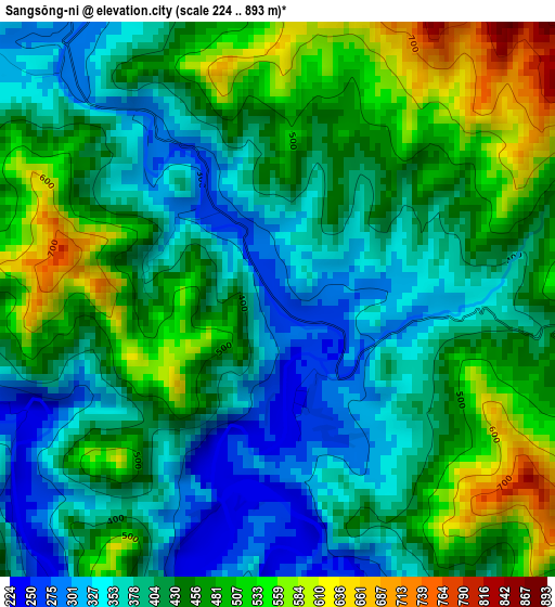
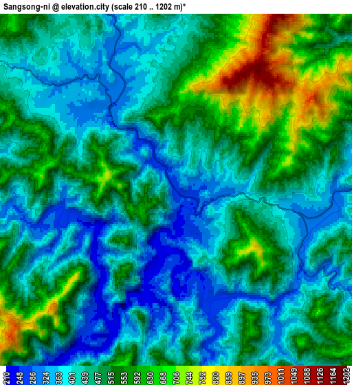
Below is the Elevation map of Sangsŏng-ni, which displays elevation range with different colors. Scale of the first map is from 224 to 893 m (735 to 2930 ft) with average elevation of 430.7 meters (=1413 ft) [note 1]
These maps also provides idea of topography and contour of this city, they are displayed at different zoom levels. More info about maps, scale and edge coordinates you can find below images.
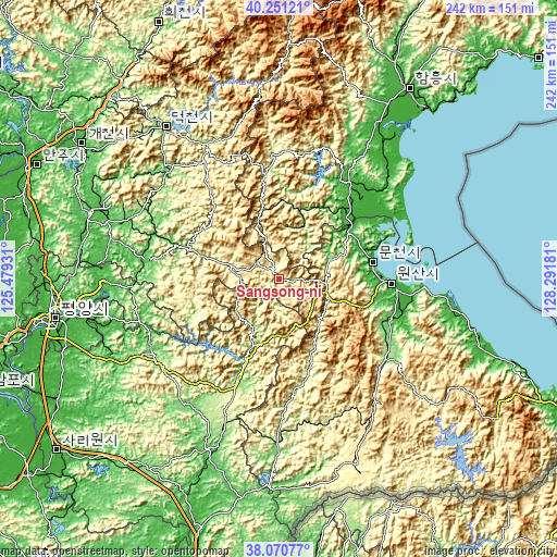
| \ | Map #1 | Map #2 | Topo.Map |
| Scale [m] | 224..893 m | 210..1202 m | × |
| Scale [ft] | 735..2930 ft | 689..3944 ft | × |
| Average | 430.7 m = 1413 ft | 474.7 m = 1557 ft | × |
| Width | 7.58 km = 4.7 mi | 15.15 km = 9.4 mi | 242.4 km = 150.6 mi |
| Height | 7.58 km = 4.7 mi | 15.15 km = 9.4 mi | 242.4 km = 150.6 mi |
| ↑Max Latitude | 39.203502° | 39.237547° | 40.25121° |
| Latitude at center | 39.16944° | 39.16944° | 39.16944° |
| ↓Min Latitude | 39.135362° | 39.101267° | 38.07077° |
| ← Min Longitude | 126.841615° | 126.797669° | 125.47931° |
| Longitude center | 126.88556° | 126.88556° | 126.88556° |
| →Max Longitude | 126.929505° | 126.973451° | 128.29181° |
Nearby cities:
Cities around Sangsŏng-ni sort by population:
• Sunch’ŏn elevation 72 m
87 km,  289°
289°
• Wŏnsan 7 m
48.1 km,  92°
92°
• P’yŏngsŏng 53 m
87.7 km,  275°
275°
• Sŭngho 1-tong 38 m
80.8 km,  255°
255°
• Anbyŏn-ŭp 17 m
56.9 km,  104°
104°
• Kangdong-ŭp 43 m
68.1 km,  267°
267°
• Kosan 195 m
57.7 km,  127°
127°
• Kowŏn-ŭp 9 m
42.9 km,  45°
45°
• Hoeyang 354 m
80 km, 129°
• T’ongch’ŏn-ŭp 6 m
90.1 km,  105°
105°
• Sinsang-ni 12 m
69.7 km,  39°
39°
• Koksan 165 m
47.1 km,  203°
203°
Multilingual:
 En español:
Sangsŏng-ni elevación 263 m.
 En France:
Sangsŏng-ni élévation 263 m.
 Auf Deutsch:
Sangsŏng-ni höhe über dem Meeresspiegel ist 263 m.

Sources and notes:
- [note 1] Map square and city borders are not equal. Map elevation data is calculated only from area inside that square.
- [src 1] Elevation data from geonames database provided with same terms of usage.
- [src 2] The elevation map of Sangsŏng-ni is generated using elevation data from NASA's 3 arcsec (90m) resolution SRTM data.
- [src 3] Base (background) map © OpenStreetMap contributors tiles are generated by Geofabrik and OpenTopoMap.
Copyright & License:
This Sangsŏng-ni Elevation Map is licensed under CC BY-SA. You may reuse any part from this page, if you give a proper credit by linking to this URL:
 More info on terms of use page.