Lingoni elevation
Lingoni (Anjouan), Comoros elevation is 208 meters and Lingoni elevation in feet is 682 ft above sea level [src 1]. Lingoni is a populated place (feature code) with elevation that is 14 meters (46 ft) bigger than average city elevation in Comoros.
Below is the Elevation map of Lingoni, which displays elevation range with different colors. Scale of the first map is from 0 to 1584 m (0 to 5197 ft) with average elevation of 595.6 meters (=1954 ft) [note 1]
These maps also provides idea of topography and contour of this city, they are displayed at different zoom levels. More info about maps, scale and edge coordinates you can find below images.
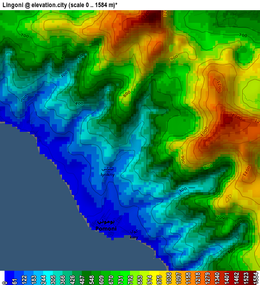
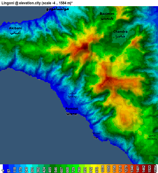
| \ | Map #1 | Map #2 | Topo.Map |
| Scale [m] | 0..1584 m | -4..1584 m | × |
| Scale [ft] | 0..5197 ft | -13..5197 ft | × |
| Average | 595.6 m = 1954 ft | 555.1 m = 1821 ft | × |
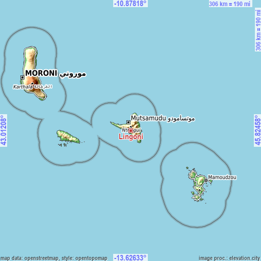
| Width | 9.55 km = 5.9 mi | 19.1 km = 11.9 mi | 305.6 km = 189.9 mi |
| Height | 9.55 km = 5.9 mi | 19.1 km = 11.9 mi | 305.6 km = 189.9 mi |
| ↑Max Latitude | -12.212883° | -12.169928° | -10.87818° |
| Latitude at center | -12.25583° | -12.25583° | -12.25583° |
| ↓Min Latitude | -12.29877° | -12.341704° | -13.62633° |
| ← Min Longitude | 44.374385° | 44.330439° | 43.01208° |
| Longitude center | 44.41833° | 44.41833° | 44.41833° |
| →Max Longitude | 44.462275° | 44.506221° | 45.82458° |
Nearby cities:
Cities around Lingoni sort by population:
• Tsimbeo elevation 433 m
7.5 km,  42°
42°
• Adda-Douéni 706 m
9.5 km,  115°
115°
• Koni-Djodjo 662 m
7.5 km,  67°
67°
• Moya 142 m
6.3 km,  161°
161°
• Chandra 469 m
8.4 km, 36°
• Kangani 136 m
9.4 km,  140°
140°
• Koni-Ngani 814 m
8 km,  56°
56°
• Mjimandra 145 m
8.8 km,  323°
323°
• Vouani 85 m
4.9 km,  285°
285°
• Magnassini-Nindri 93 m
2.5 km,  186°
186°
• Ouzini 680 m
6.8 km,  100°
100°
• Limbi 380 m
9.6 km,  79°
79°
Multilingual:
 En español:
Lingoni elevación 208 m.
 En France:
Lingoni élévation 208 m.


Sources and notes:
- [note 1] Map square and city borders are not equal. Map elevation data is calculated only from area inside that square.
- [src 1] Elevation data from geonames database provided with same terms of usage.
- [src 2] The elevation map of Lingoni is generated using elevation data from NASA's 3 arcsec (90m) resolution SRTM data.
- [src 3] Base (background) map © OpenStreetMap contributors tiles are generated by Geofabrik and OpenTopoMap.
Copyright & License:
This Lingoni Elevation Map is licensed under CC BY-SA. You may reuse any part from this page, if you give a proper credit by linking to this URL:
 More info on terms of use page.