Mitsamiouli elevation
Mitsamiouli (Grande Comore), Comoros elevation is 48 meters and Mitsamiouli elevation in feet is 157 ft above sea level [src 1]. Mitsamiouli is a populated place (feature code) with elevation that is 146 meters (479 ft) smaller than average city elevation in Comoros.
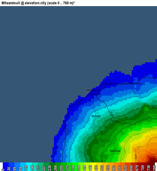
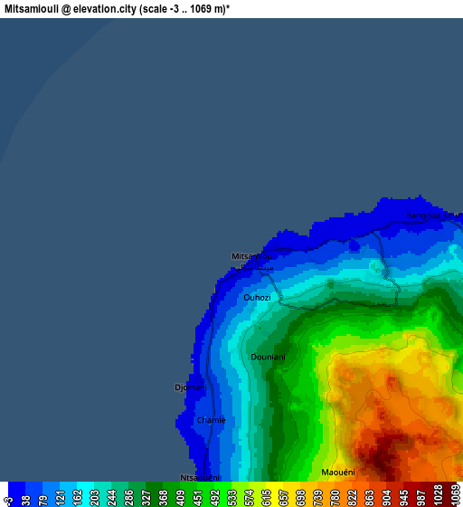
Below is the Elevation map of Mitsamiouli, which displays elevation range with different colors. Scale of the first map is from 0 to 768 m (0 to 2520 ft) with average elevation of 196.3 meters (=644 ft) [note 1]
These maps also provides idea of topography and contour of this city, they are displayed at different zoom levels. More info about maps, scale and edge coordinates you can find below images.
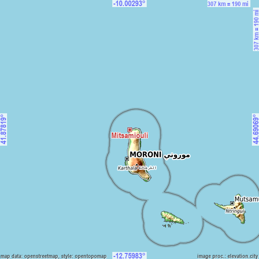
| \ | Map #1 | Map #2 | Topo.Map |
| Scale [m] | 0..768 m | -3..1069 m | × |
| Scale [ft] | 0..2520 ft | -10..3507 ft | × |
| Average | 196.3 m = 644 ft | 372 m = 1220 ft | × |
| Width | 9.58 km = 6 mi | 19.16 km = 11.9 mi | 306.5 km = 190.4 mi |
| Height | 9.58 km = 6 mi | 19.16 km = 11.9 mi | 306.6 km = 190.5 mi |
| ↑Max Latitude | -11.341636° | -11.298546° | -10.00293° |
| Latitude at center | -11.38472° | -11.38472° | -11.38472° |
| ↓Min Latitude | -11.427797° | -11.470868° | -12.75983° |
| ← Min Longitude | 43.240495° | 43.196549° | 41.87819° |
| Longitude center | 43.28444° | 43.28444° | 43.28444° |
| →Max Longitude | 43.328385° | 43.372331° | 44.69069° |
Nearby cities:
Cities around Mitsamiouli sort by population:
• Ouellah elevation 140 m
5.2 km,  96°
96°
• Ntsaouéni 26 m
9.3 km,  194°
194°
• Chezani 182 m
13.2 km,  113°
113°
• Hantsindzi 19 m
14.8 km, 110°
• Ouhozi 59 m
2.3 km, 186°
• Douniani 239 m
4.1 km,  173°
173°
• Mandza 271 m
3.9 km,  162°
162°
• Koua 80 m
4.1 km, 192°
• Itsandzéni 435 m
14.7 km,  131°
131°
• Bambadjani 577 m
14.5 km,  135°
135°
• Ivouani 21 m
12 km,  93°
93°
• Bouni 241 m
16 km, 135°
Multilingual:
 En español:
Mitsamiouli elevación 48 m.
 En France:
Mitsamiouli élévation 48 m.
 Auf Deutsch:
Mitsamiouli höhe über dem Meeresspiegel ist 48 m.

Sources and notes:
- [note 1] Map square and city borders are not equal. Map elevation data is calculated only from area inside that square.
- [src 1] Elevation data from geonames database provided with same terms of usage.
- [src 2] The elevation map of Mitsamiouli is generated using elevation data from NASA's 3 arcsec (90m) resolution SRTM data.
- [src 3] Base (background) map © OpenStreetMap contributors tiles are generated by Geofabrik and OpenTopoMap.
Copyright & License:
This Mitsamiouli Elevation Map is licensed under CC BY-SA. You may reuse any part from this page, if you give a proper credit by linking to this URL:
 More info on terms of use page.