Moutsamoudou elevation
Moutsamoudou (Anjouan), Comoros elevation is 61 meters and Moutsamoudou elevation in feet is 200 ft above sea level [src 1]. Moutsamoudou is a seat of a first-order administrative division (feature code) with elevation that is 133 meters (436 ft) smaller than average city elevation in Comoros.
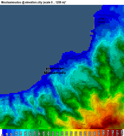
Below is the Elevation map of Moutsamoudou, which displays elevation range with different colors. Scale of the first map is from 0 to 1259 m (0 to 4131 ft) with average elevation of 378.4 meters (=1241 ft) [note 1]
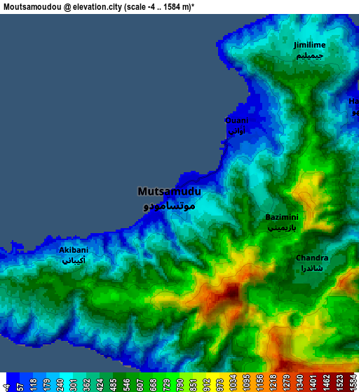
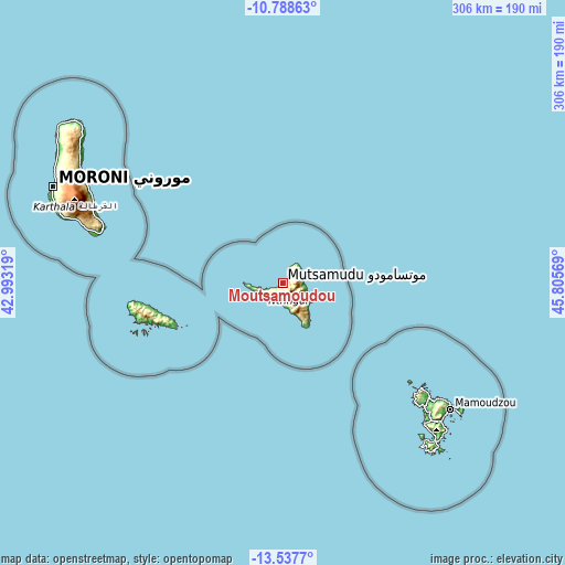
These maps also provides idea of topography and contour of this city, they are displayed at different zoom levels. More info about maps, scale and edge coordinates you can find below images.
| \ | Map #1 | Map #2 | Topo.Map |
| Scale [m] | 0..1259 m | -4..1584 m | × |
| Scale [ft] | 0..4131 ft | -13..5197 ft | × |
| Average | 378.4 m = 1241 ft | 481.3 m = 1579 ft | × |
| Width | 9.55 km = 5.9 mi | 19.11 km = 11.9 mi | 305.7 km = 190 mi |
| Height | 9.55 km = 5.9 mi | 19.11 km = 11.9 mi | 305.7 km = 190 mi |
| ↑Max Latitude | -12.123758° | -12.08079° | -10.78863° |
| Latitude at center | -12.16672° | -12.16672° | -12.16672° |
| ↓Min Latitude | -12.209675° | -12.252623° | -13.5377° |
| ← Min Longitude | 44.355495° | 44.311549° | 42.99319° |
| Longitude center | 44.39944° | 44.39944° | 44.39944° |
| →Max Longitude | 44.443385° | 44.487331° | 45.80569° |
Nearby cities:
Cities around Moutsamoudou sort by population:
• Tsimbeo elevation 433 m
8.3 km,  121°
121°
• Ouani 18 m
4.4 km,  38°
38°
• Mirontsi 50 m
1.5 km, 39°
• Barakani 57 m
4.6 km,  46°
46°
• Chandra 469 m
7.8 km,  113°
113°
• Koki 380 m
4.6 km,  96°
96°
• Mjimandra 145 m
4.2 km,  228°
228°
• Vouani 85 m
9 km,  197°
197°
• Chironkamba 158 m
5.8 km,  242°
242°
• Pajé 30 m
1.3 km,  254°
254°
• Patsi 284 m
4.3 km,  73°
73°
• Chitrouni 39 m
7.3 km, 252°
Multilingual:
 En español:
Moutsamoudou elevación 61 m.
 En France:
Moutsamoudou élévation 61 m.
 Auf Deutsch:
Moutsamoudou höhe über dem Meeresspiegel ist 61 m.

Sources and notes:
- [note 1] Map square and city borders are not equal. Map elevation data is calculated only from area inside that square.
- [src 1] Elevation data from geonames database provided with same terms of usage.
- [src 2] The elevation map of Moutsamoudou is generated using elevation data from NASA's 3 arcsec (90m) resolution SRTM data.
- [src 3] Base (background) map © OpenStreetMap contributors tiles are generated by Geofabrik and OpenTopoMap.
Copyright & License:
This Moutsamoudou Elevation Map is licensed under CC BY-SA. You may reuse any part from this page, if you give a proper credit by linking to this URL:
 More info on terms of use page.