Sima elevation
Sima (Anjouan), Comoros elevation is 120 meters and Sima elevation in feet is 394 ft above sea level [src 1]. Sima is a populated place (feature code) with elevation that is 74 meters (243 ft) smaller than average city elevation in Comoros.
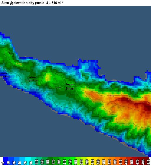
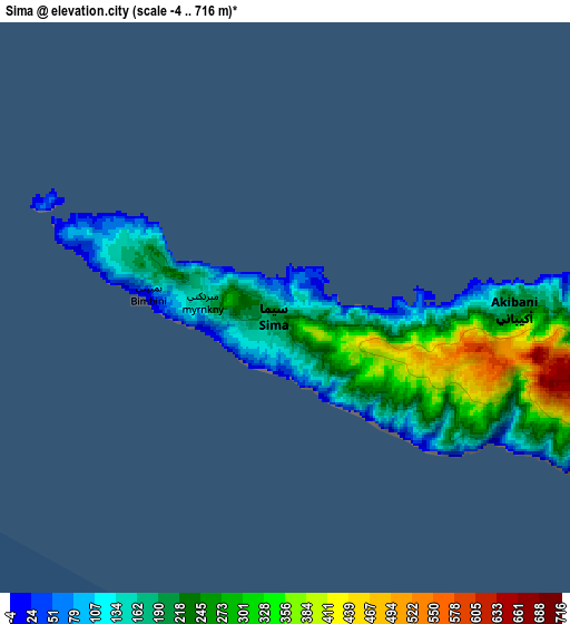
Below is the Elevation map of Sima, which displays elevation range with different colors. Scale of the first map is from -4 to 516 m (-13 to 1693 ft) with average elevation of 175.2 meters (=575 ft) [note 1]
These maps also provides idea of topography and contour of this city, they are displayed at different zoom levels. More info about maps, scale and edge coordinates you can find below images.
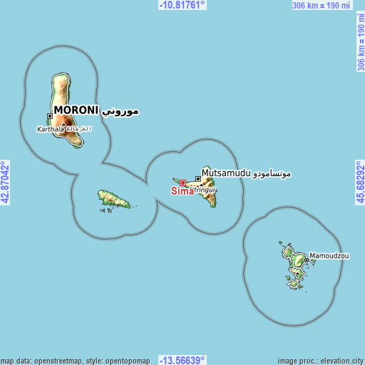
| \ | Map #1 | Map #2 | Topo.Map |
| Scale [m] | -4..516 m | -4..716 m | × |
| Scale [ft] | -13..1693 ft | -13..2349 ft | × |
| Average | 175.2 m = 575 ft | 225.9 m = 741 ft | × |
| Width | 9.55 km = 5.9 mi | 19.1 km = 11.9 mi | 305.6 km = 189.9 mi |
| Height | 9.55 km = 5.9 mi | 19.1 km = 11.9 mi | 305.7 km = 190 mi |
| ↑Max Latitude | -12.152603° | -12.109639° | -10.81761° |
| Latitude at center | -12.19556° | -12.19556° | -12.19556° |
| ↓Min Latitude | -12.23851° | -12.281453° | -13.56639° |
| ← Min Longitude | 44.232725° | 44.188779° | 42.87042° |
| Longitude center | 44.27667° | 44.27667° | 44.27667° |
| →Max Longitude | 44.320615° | 44.364561° | 45.68292° |
Nearby cities:
Cities around Sima sort by population:
• Mjimandra elevation 145 m
10.2 km,  87°
87°
• Vouani 85 m
11.9 km,  116°
116°
• Boungouéni 412 m
2.7 km,  114°
114°
• Chironkamba 158 m
8.3 km, 86°
• Kavani 160 m
0.9 km,  297°
297°
• Bimbini 151 m
4.5 km,  280°
280°
• Pajé 30 m
12.4 km,  76°
76°
• Bandajou 40 m
1.2 km,  68°
68°
• Mjamaoué 12 m
3.6 km, 86°
• Maraharé 81 m
5.6 km,  134°
134°
• Assimpao 125 m
6.3 km, 131°
• Chitrouni 39 m
6.5 km, 80°
Multilingual:
 En español:
Sima elevación 120 m.
 En France:
Sima élévation 120 m.


Sources and notes:
- [note 1] Map square and city borders are not equal. Map elevation data is calculated only from area inside that square.
- [src 1] Elevation data from geonames database provided with same terms of usage.
- [src 2] The elevation map of Sima is generated using elevation data from NASA's 3 arcsec (90m) resolution SRTM data.
- [src 3] Base (background) map © OpenStreetMap contributors tiles are generated by Geofabrik and OpenTopoMap.
Copyright & License:
This Sima Elevation Map is licensed under CC BY-SA. You may reuse any part from this page, if you give a proper credit by linking to this URL:
 More info on terms of use page.