Smach Mean Chey elevation
Smach Mean Chey (Koh Kong), Cambodia elevation is 5 meters and Smach Mean Chey elevation in feet is 16 ft above sea level [src 1]. Smach Mean Chey is a seat of a second-order administrative division (feature code) with elevation that is 47 meters (154 ft) smaller than average city elevation in Cambodia.
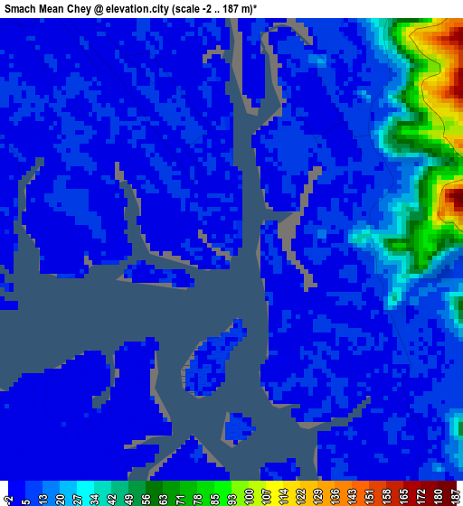
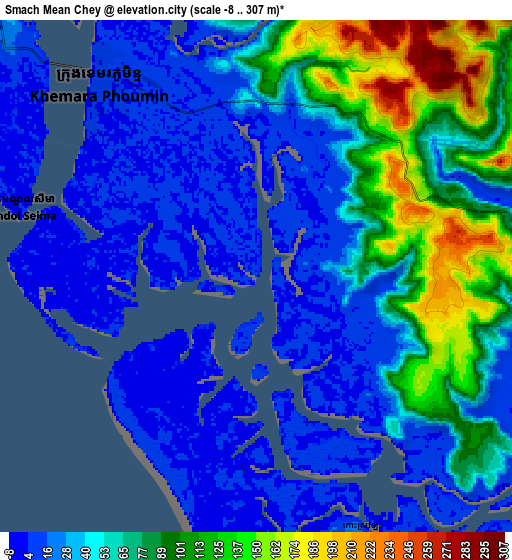
Below is the Elevation map of Smach Mean Chey, which displays elevation range with different colors. Scale of the first map is from -2 to 187 m (-7 to 614 ft) with average elevation of 13.9 meters (=46 ft) [note 1]
These maps also provides idea of topography and contour of this city, they are displayed at different zoom levels. More info about maps, scale and edge coordinates you can find below images.
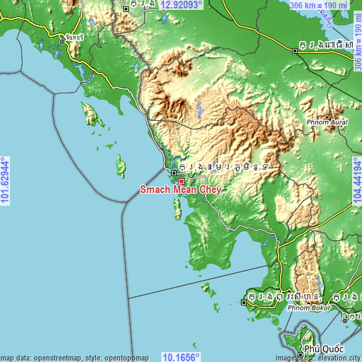
| \ | Map #1 | Map #2 | Topo.Map |
| Scale [m] | -2..187 m | -8..307 m | × |
| Scale [ft] | -7..614 ft | -26..1007 ft | × |
| Average | 13.9 m = 46 ft | 54.3 m = 178 ft | × |
| Width | 9.57 km = 5.9 mi | 19.15 km = 11.9 mi | 306.4 km = 190.4 mi |
| Height | 9.57 km = 5.9 mi | 19.15 km = 11.9 mi | 306.4 km = 190.4 mi |
| ↑Max Latitude | 11.589703° | 11.632749° | 12.92093° |
| Latitude at center | 11.54665° | 11.54665° | 11.54665° |
| ↓Min Latitude | 11.503591° | 11.460525° | 10.1656° |
| ← Min Longitude | 102.991745° | 102.947799° | 101.62944° |
| Longitude center | 103.03569° | 103.03569° | 103.03569° |
| →Max Longitude | 103.079635° | 103.123581° | 104.44194° |
Nearby cities:
Cities around Smach Mean Chey sort by population:
• Sihanoukville elevation 6 m
117.3 km,  152°
152°
• Koh Kong 5 m
9.5 km,  323°
323°
• Phnum Kravanh 36 m
119.9 km,  41°
41°
• Mittakpheap 23 m
115.8 km, 152°
• Kampong Seila 9 m
107 km,  118°
118°
• Srae Ambel 16 m
91.4 km, 121°
• Veal Veaeng 242 m
84.6 km,  4°
4°
• Botum Sakor 20 m
62.1 km,  130°
130°
• Thma Bang 188 m
54.6 km,  80°
80°
• Mondul Seima 23 m
12.7 km,  312°
312°
• Bak Khlang 4 m
9.1 km,  285°
285°
• Smach Meanchey 6 m
8.2 km, 320°
Multilingual:
 En español:
Smach Mean Chey elevación 5 m.
 En France:
Smach Mean Chey élévation 5 m.
 Auf Deutsch:
Smach Mean Chey höhe über dem Meeresspiegel ist 5 m.

Sources and notes:
- [note 1] Map square and city borders are not equal. Map elevation data is calculated only from area inside that square.
- [src 1] Elevation data from geonames database provided with same terms of usage.
- [src 2] The elevation map of Smach Mean Chey is generated using elevation data from NASA's 3 arcsec (90m) resolution SRTM data.
- [src 3] Base (background) map © OpenStreetMap contributors tiles are generated by Geofabrik and OpenTopoMap.
Copyright & License:
This Smach Mean Chey Elevation Map is licensed under CC BY-SA. You may reuse any part from this page, if you give a proper credit by linking to this URL:
 More info on terms of use page.