Kampong Thom elevation
Kampong Thom, Cambodia elevation is 16 meters and Kampong Thom elevation in feet is 52 ft above sea level [src 1]. Kampong Thom is a seat of a first-order administrative division (feature code) with elevation that is 36 meters (118 ft) smaller than average city elevation in Cambodia.
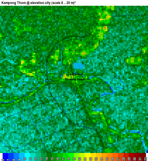
Below is the Elevation map of Kampong Thom, which displays elevation range with different colors. Scale of the first map is from 6 to 25 m (20 to 82 ft) with average elevation of 13.4 meters (=44 ft) [note 1]
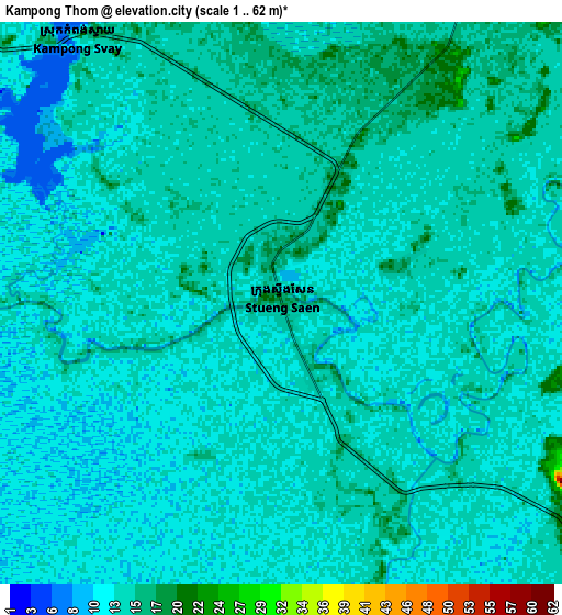
These maps also provides idea of topography and contour of this city, they are displayed at different zoom levels. More info about maps, scale and edge coordinates you can find below images.
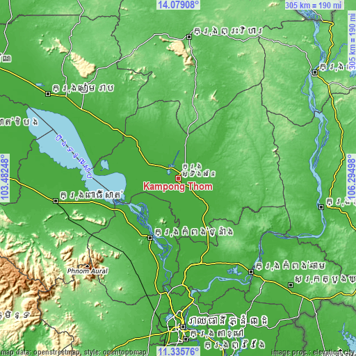
| \ | Map #1 | Map #2 | Topo.Map |
| Scale [m] | 6..25 m | 1..62 m | × |
| Scale [ft] | 20..82 ft | 3..203 ft | × |
| Average | 13.4 m = 44 ft | 13.3 m = 44 ft | × |
| Width | 9.53 km = 5.9 mi | 19.07 km = 11.8 mi | 305 km = 189.5 mi |
| Height | 9.53 km = 5.9 mi | 19.07 km = 11.8 mi | 305.1 km = 189.6 mi |
| ↑Max Latitude | 12.753985° | 12.796842° | 14.07908° |
| Latitude at center | 12.71112° | 12.71112° | 12.71112° |
| ↓Min Latitude | 12.668248° | 12.625369° | 11.33576° |
| ← Min Longitude | 104.844785° | 104.800839° | 103.48248° |
| Longitude center | 104.88873° | 104.88873° | 104.88873° |
| →Max Longitude | 104.932675° | 104.976621° | 106.29498° |
Nearby cities:
Cities around Kampong Thom sort by population:
• Kampong Chhnang elevation 21 m
56.7 km,  205°
205°
• Prey Chhor 32 m
82.9 km,  151°
151°
• Batheay 17 m
80.5 km,  175°
175°
• Cheung Prey 17 m
75.5 km,  164°
164°
• Chi Kraeng 21 m
74.5 km,  307°
307°
• Chamkar Leu 52 m
61.8 km,  136°
136°
• Sandan 24 m
59 km,  42°
42°
• Baribour 21 m
55.3 km,  236°
236°
• Kampong Leaeng 16 m
51.6 km,  199°
199°
• Stoung 17 m
42.9 km, 306°
• Baray 17 m
40.6 km, 150°
• Stueng Saen 16 m
0.3 km,  87°
87°
Multilingual:
 En español:
Kampong Thom elevación 16 m.
 En France:
Kampong Thom élévation 16 m.
 Auf Deutsch:
Kampong Thom höhe über dem Meeresspiegel ist 16 m.

Sources and notes:
- [note 1] Map square and city borders are not equal. Map elevation data is calculated only from area inside that square.
- [src 1] Elevation data from geonames database provided with same terms of usage.
- [src 2] The elevation map of Kampong Thom is generated using elevation data from NASA's 3 arcsec (90m) resolution SRTM data.
- [src 3] Base (background) map © OpenStreetMap contributors tiles are generated by Geofabrik and OpenTopoMap.
Copyright & License:
This Kampong Thom Elevation Map is licensed under CC BY-SA. You may reuse any part from this page, if you give a proper credit by linking to this URL:
 More info on terms of use page.