Paoy Paet elevation
Paoy Paet (Banteay Meanchey), Cambodia elevation is 43 meters and Paoy Paet elevation in feet is 141 ft above sea level [src 1]. Paoy Paet is a populated place (feature code) with elevation that is 9 meters (30 ft) smaller than average city elevation in Cambodia.
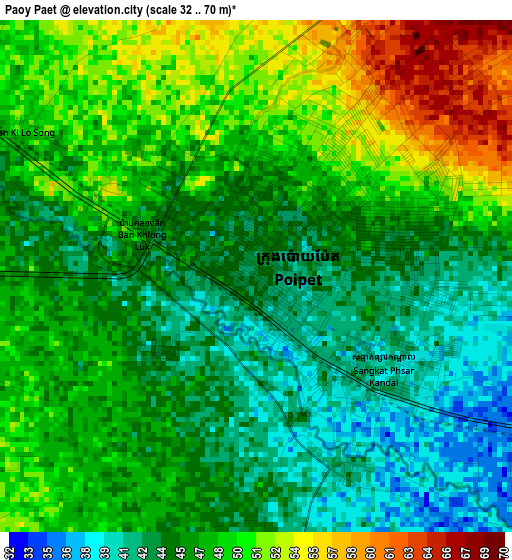
Below is the Elevation map of Paoy Paet, which displays elevation range with different colors. Scale of the first map is from 32 to 70 m (105 to 230 ft) with average elevation of 46.7 meters (=153 ft) [note 1]
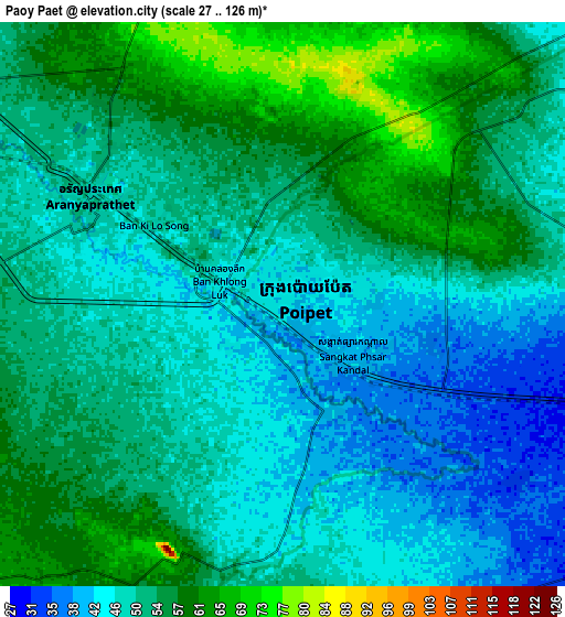
These maps also provides idea of topography and contour of this city, they are displayed at different zoom levels. More info about maps, scale and edge coordinates you can find below images.
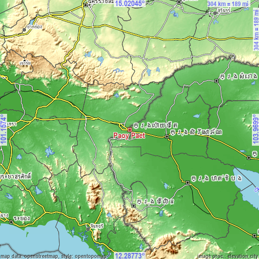
| \ | Map #1 | Map #2 | Topo.Map |
| Scale [m] | 32..70 m | 27..126 m | × |
| Scale [ft] | 105..230 ft | 89..413 ft | × |
| Average | 46.7 m = 153 ft | 51 m = 167 ft | × |
| Width | 9.5 km = 5.9 mi | 18.99 km = 11.8 mi | 303.8 km = 188.8 mi |
| Height | 9.5 km = 5.9 mi | 18.99 km = 11.8 mi | 303.9 km = 188.8 mi |
| ↑Max Latitude | 13.700749° | 13.74344° | 15.02045° |
| Latitude at center | 13.65805° | 13.65805° | 13.65805° |
| ↓Min Latitude | 13.615343° | 13.572629° | 12.28773° |
| ← Min Longitude | 102.519705° | 102.475759° | 101.1574° |
| Longitude center | 102.56365° | 102.56365° | 102.56365° |
| →Max Longitude | 102.607595° | 102.651541° | 103.9699° |
Nearby cities:
Cities around Paoy Paet sort by population:
• Sisophon elevation 19 m
45 km,  100°
100°
• Sala Krau 105 m
78.2 km,  176°
176°
• Bat Dambang 15 m
71.9 km,  127°
127°
• Preah Netr Preah 16 m
66.9 km,  93°
93°
• Kamrieng 84 m
63.9 km,  187°
187°
• Thma Puok 42 m
61.4 km,  59°
59°
• Bavel 24 m
56.6 km,  143°
143°
• Mongkol Borei 16 m
51.7 km, 104°
• Phnum Proek 127 m
51.6 km,  200°
200°
• Svay Chek 29 m
46 km,  69°
69°
• Sampov Lun 176 m
32.3 km,  218°
218°
• Ou Chrov 43 m
3 km, 134°
Multilingual:
 En español:
Paoy Paet elevación 43 m.
 En France:
Poipet élévation 43 m.
 Auf Deutsch:
Paoy Paet höhe über dem Meeresspiegel ist 43 m.

Sources and notes:
- [note 1] Map square and city borders are not equal. Map elevation data is calculated only from area inside that square.
- [src 1] Elevation data from geonames database provided with same terms of usage.
- [src 2] The elevation map of Paoy Paet is generated using elevation data from NASA's 3 arcsec (90m) resolution SRTM data.
- [src 3] Base (background) map © OpenStreetMap contributors tiles are generated by Geofabrik and OpenTopoMap.
Copyright & License:
This Paoy Paet Elevation Map is licensed under CC BY-SA. You may reuse any part from this page, if you give a proper credit by linking to this URL:
 More info on terms of use page.