Samraong elevation
Samraong (Ŏtâr Méanchey), Cambodia elevation is 52 meters and Samraong elevation in feet is 171 ft above sea level [src 1]. Samraong is a seat of a first-order administrative division (feature code) with elevation that is 0 meters (0 ft) bigger than average city elevation in Cambodia.
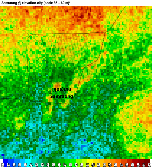
Below is the Elevation map of Samraong, which displays elevation range with different colors. Scale of the first map is from 36 to 60 m (118 to 197 ft) with average elevation of 47.7 meters (=156 ft) [note 1]
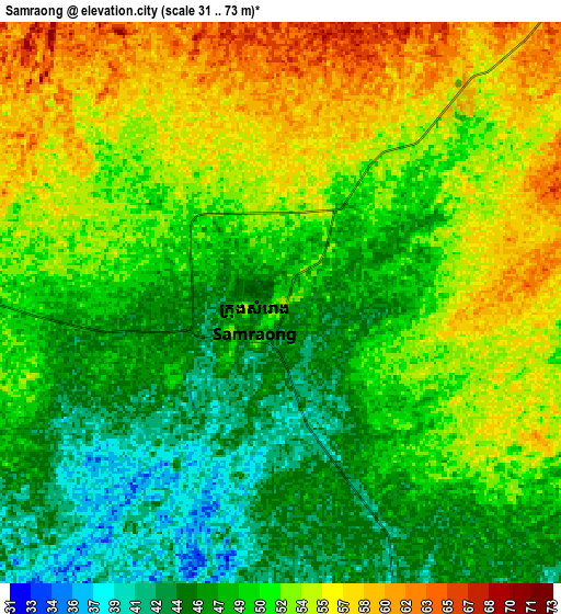
These maps also provides idea of topography and contour of this city, they are displayed at different zoom levels. More info about maps, scale and edge coordinates you can find below images.
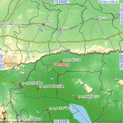
| \ | Map #1 | Map #2 | Topo.Map |
| Scale [m] | 36..60 m | 31..73 m | × |
| Scale [ft] | 118..197 ft | 102..240 ft | × |
| Average | 47.7 m = 156 ft | 50.6 m = 166 ft | × |
| Width | 9.47 km = 5.9 mi | 18.95 km = 11.8 mi | 303.2 km = 188.4 mi |
| Height | 9.47 km = 5.9 mi | 18.95 km = 11.8 mi | 303.2 km = 188.4 mi |
| ↑Max Latitude | 14.224352° | 14.266946° | 15.54092° |
| Latitude at center | 14.18175° | 14.18175° | 14.18175° |
| ↓Min Latitude | 14.13914° | 14.096522° | 12.81438° |
| ← Min Longitude | 103.473665° | 103.429719° | 102.11136° |
| Longitude center | 103.51761° | 103.51761° | 103.51761° |
| →Max Longitude | 103.561555° | 103.605501° | 104.92386° |
Nearby cities:
Cities around Samraong sort by population:
• Sisophon elevation 19 m
88.5 km,  221°
221°
• Mongkol Borei 16 m
88.8 km, 216°
• Angkor Thum 30 m
86.7 km,  153°
153°
• Svay Chek 29 m
73.1 km,  235°
235°
• Preah Netr Preah 16 m
71.8 km,  210°
210°
• Kralanh 21 m
65 km,  189°
189°
• Anlong Veaeng 54 m
61 km,  84°
84°
• Angkor Chum 28 m
57.1 km,  165°
165°
• Thma Puok 42 m
56.9 km, 241°
• Phnum Srok 23 m
52.4 km,  201°
201°
• Varin 48 m
50.5 km, 148°
• Srei Snam 26 m
38.6 km,  180°
180°
Multilingual:
 En español:
Samraong elevación 52 m.
 En France:
Samraong élévation 52 m.


Sources and notes:
- [note 1] Map square and city borders are not equal. Map elevation data is calculated only from area inside that square.
- [src 1] Elevation data from geonames database provided with same terms of usage.
- [src 2] The elevation map of Samraong is generated using elevation data from NASA's 3 arcsec (90m) resolution SRTM data.
- [src 3] Base (background) map © OpenStreetMap contributors tiles are generated by Geofabrik and OpenTopoMap.
Copyright & License:
This Samraong Elevation Map is licensed under CC BY-SA. You may reuse any part from this page, if you give a proper credit by linking to this URL:
 More info on terms of use page.