Takeo elevation
Takeo, Cambodia elevation is 12 meters and Takeo elevation in feet is 39 ft above sea level [src 1]. Takeo is a seat of a first-order administrative division (feature code) with elevation that is 40 meters (131 ft) smaller than average city elevation in Cambodia.
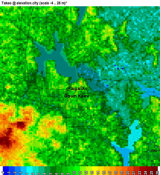
Below is the Elevation map of Takeo, which displays elevation range with different colors. Scale of the first map is from -4 to 26 m (-13 to 85 ft) with average elevation of 7.7 meters (=25 ft) [note 1]
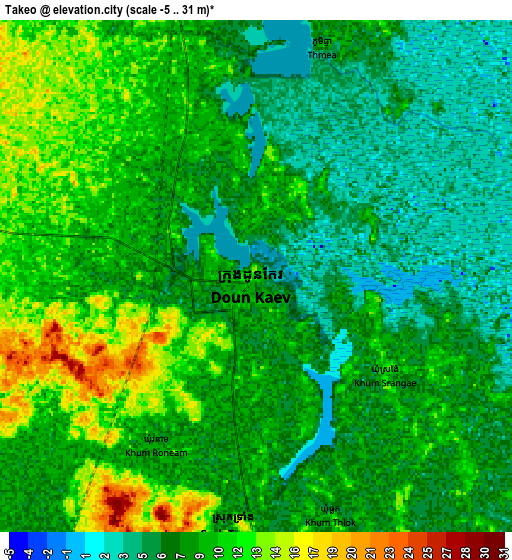
These maps also provides idea of topography and contour of this city, they are displayed at different zoom levels. More info about maps, scale and edge coordinates you can find below images.
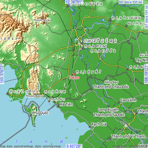
| \ | Map #1 | Map #2 | Topo.Map |
| Scale [m] | -4..26 m | -5..31 m | × |
| Scale [ft] | -13..85 ft | -16..102 ft | × |
| Average | 7.7 m = 25 ft | 8.4 m = 28 ft | × |
| Width | 9.59 km = 6 mi | 19.19 km = 11.9 mi | 307 km = 190.8 mi |
| Height | 9.59 km = 6 mi | 19.19 km = 11.9 mi | 307 km = 190.8 mi |
| ↑Max Latitude | 11.033946° | 11.077076° | 12.36791° |
| Latitude at center | 10.99081° | 10.99081° | 10.99081° |
| ↓Min Latitude | 10.947668° | 10.904519° | 9.60725° |
| ← Min Longitude | 104.741035° | 104.697089° | 103.37873° |
| Longitude center | 104.78498° | 104.78498° | 104.78498° |
| →Max Longitude | 104.828925° | 104.872871° | 106.19123° |
Nearby cities:
Cities around Takeo sort by population:
• Phumĭ Véal Srê elevation 10 m
1.3 km,  213°
213°
• Peam Chor 6 m
49.1 km,  75°
75°
• S’ang 12 m
47.8 km,  30°
30°
• Kandal Stueng 16 m
47.2 km,  5°
5°
• Banteay Meas 9 m
43.5 km, 214°
• Kiri Vongs 14 m
40.4 km,  166°
166°
• Chum Kiri 52 m
40.3 km,  259°
259°
• Chhuk 32 m
39.9 km,  244°
244°
• Koah Thum 13 m
33.2 km,  63°
63°
• Basedth 44 m
32.3 km,  302°
302°
• Bourei Cholsar 6 m
30.9 km,  124°
124°
• Tram Kak 14 m
12.1 km,  281°
281°
Multilingual:
 En español:
Takeo elevación 12 m.
 En France:
Takeo élévation 12 m.


Sources and notes:
- [note 1] Map square and city borders are not equal. Map elevation data is calculated only from area inside that square.
- [src 1] Elevation data from geonames database provided with same terms of usage.
- [src 2] The elevation map of Takeo is generated using elevation data from NASA's 3 arcsec (90m) resolution SRTM data.
- [src 3] Base (background) map © OpenStreetMap contributors tiles are generated by Geofabrik and OpenTopoMap.
Copyright & License:
This Takeo Elevation Map is licensed under CC BY-SA. You may reuse any part from this page, if you give a proper credit by linking to this URL:
 More info on terms of use page.