Kochkor-Ata elevation
Kochkor-Ata (Jalal-Abad), Kyrgyzstan elevation is 618 meters and Kochkor-Ata elevation in feet is 2028 ft above sea level [src 1]. Kochkor-Ata is a populated place (feature code) with elevation that is 578 meters (1896 ft) smaller than average city elevation in Kyrgyzstan.
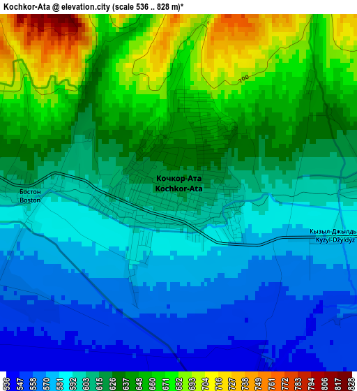
Below is the Elevation map of Kochkor-Ata, which displays elevation range with different colors. Scale of the first map is from 536 to 828 m (1759 to 2717 ft) with average elevation of 616.2 meters (=2022 ft) [note 1]
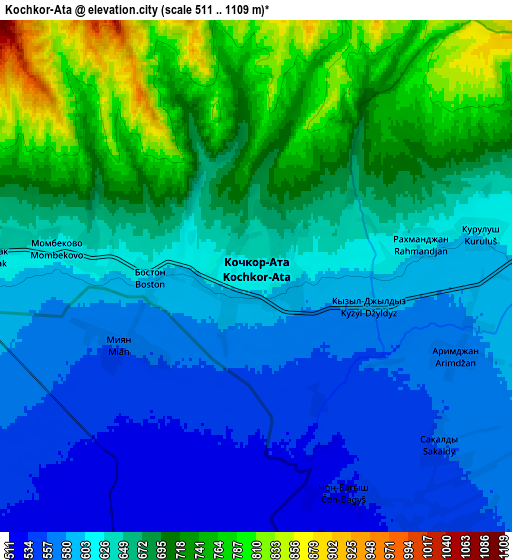
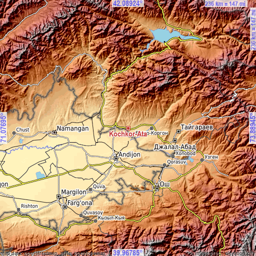
These maps also provides idea of topography and contour of this city, they are displayed at different zoom levels. More info about maps, scale and edge coordinates you can find below images.
| \ | Map #1 | Map #2 | Topo.Map |
| Scale [m] | 536..828 m | 511..1109 m | × |
| Scale [ft] | 1759..2717 ft | 1677..3638 ft | × |
| Average | 616.2 m = 2022 ft | 644.6 m = 2115 ft | × |
| Width | 7.37 km = 4.6 mi | 14.74 km = 9.2 mi | 235.9 km = 146.6 mi |
| Height | 7.37 km = 4.6 mi | 14.74 km = 9.2 mi | 235.9 km = 146.6 mi |
| ↑Max Latitude | 41.070229° | 41.103351° | 42.08924° |
| Latitude at center | 41.03709° | 41.03709° | 41.03709° |
| ↓Min Latitude | 41.003934° | 40.970762° | 39.96785° |
| ← Min Longitude | 72.439255° | 72.395309° | 71.07695° |
| Longitude center | 72.4832° | 72.4832° | 72.4832° |
| →Max Longitude | 72.527145° | 72.571091° | 73.88945° |
Nearby cities:
Cities around Kochkor-Ata sort by population:
• Osh elevation 988 m
62.5 km,  154°
154°
• Jalal-Abad 772 m
44.9 km,  104°
104°
• Uzgen 1027 m
74.8 km,  113°
113°
• Bazar-Korgon 729 m
22 km,  89°
89°
• Tash-Kumyr 612 m
40.9 km,  327°
327°
• Kara Suu 744 m
49.1 km,  138°
138°
• Nookat 1295 m
86.5 km,  172°
172°
• Kerben 1307 m
79.1 km,  309°
309°
• Karavan 1013 m
86.2 km,  196°
196°
• Aravan 760 m
57.9 km,  178°
178°
• Suzak 714 m
38.6 km, 113°
• Massy 690 m
12.8 km,  78°
78°
Multilingual:
 En español:
Kochkor-Ata elevación 618 m.
 En France:
Kochkor-Ata élévation 618 m.
 Auf Deutsch:
Kochkor-Ata höhe über dem Meeresspiegel ist 618 m.

Sources and notes:
- [note 1] Map square and city borders are not equal. Map elevation data is calculated only from area inside that square.
- [src 1] Elevation data from geonames database provided with same terms of usage.
- [src 2] The elevation map of Kochkor-Ata is generated using elevation data from NASA's 3 arcsec (90m) resolution SRTM data.
- [src 3] Base (background) map © OpenStreetMap contributors tiles are generated by Geofabrik and OpenTopoMap.
Copyright & License:
This Kochkor-Ata Elevation Map is licensed under CC BY-SA. You may reuse any part from this page, if you give a proper credit by linking to this URL:
 More info on terms of use page.