Talas elevation
Talas, Kyrgyzstan elevation is 1238 meters and Talas elevation in feet is 4062 ft above sea level [src 1]. Talas is a seat of a first-order administrative division (feature code) with elevation that is 42 meters (138 ft) bigger than average city elevation in Kyrgyzstan.
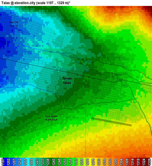
Below is the Elevation map of Talas, which displays elevation range with different colors. Scale of the first map is from 1197 to 1329 m (3927 to 4360 ft) with average elevation of 1249.5 meters (=4099 ft) [note 1]
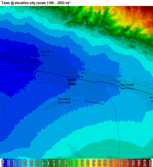
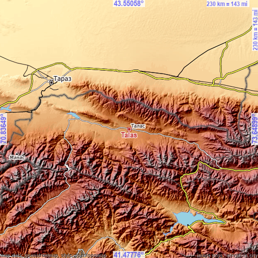
These maps also provides idea of topography and contour of this city, they are displayed at different zoom levels. More info about maps, scale and edge coordinates you can find below images.
| \ | Map #1 | Map #2 | Topo.Map |
| Scale [m] | 1197..1329 m | 1169..2053 m | × |
| Scale [ft] | 3927..4360 ft | 3835..6736 ft | × |
| Average | 1249.5 m = 4099 ft | 1312.4 m = 4306 ft | × |
| Width | 7.2 km = 4.5 mi | 14.4 km = 8.9 mi | 230.5 km = 143.2 mi |
| Height | 7.2 km = 4.5 mi | 14.4 km = 8.9 mi | 230.5 km = 143.2 mi |
| ↑Max Latitude | 42.55515° | 42.587513° | 43.55058° |
| Latitude at center | 42.52277° | 42.52277° | 42.52277° |
| ↓Min Latitude | 42.490374° | 42.45796° | 41.47776° |
| ← Min Longitude | 72.198795° | 72.154849° | 70.83649° |
| Longitude center | 72.24274° | 72.24274° | 72.24274° |
| →Max Longitude | 72.286685° | 72.330631° | 73.64899° |
Nearby cities:
Cities around Talas sort by population:
• Kara-Balta elevation 789 m
135.2 km,  76°
76°
• Tash-Kumyr 612 m
130.8 km,  180°
180°
• Toktogul 987 m
92.3 km,  141°
141°
• Kerben 1307 m
121.2 km,  199°
199°
• Kaindy 738 m
121.9 km,  74°
74°
• Kanysh-Kyya 1711 m
126.9 km,  228°
228°
• Üch-Terek 950 m
115.7 km, 136°
• Pokrovka 768 m
57 km,  294°
294°
• Kyzyl-Adyr 919 m
54.6 km,  281°
281°
• Talas 2638 m
38.8 km,  118°
118°
• Bakai-Ata 1147 m
26.4 km,  262°
262°
• Ivanovo-Alekseyevka 1209 m
3.8 km,  314°
314°
Multilingual:
 En español:
Talas elevación 1238 m.
 En France:
Talas élévation 1238 m.


Sources and notes:
- [note 1] Map square and city borders are not equal. Map elevation data is calculated only from area inside that square.
- [src 1] Elevation data from geonames database provided with same terms of usage.
- [src 2] The elevation map of Talas is generated using elevation data from NASA's 3 arcsec (90m) resolution SRTM data.
- [src 3] Base (background) map © OpenStreetMap contributors tiles are generated by Geofabrik and OpenTopoMap.
Copyright & License:
This Talas Elevation Map is licensed under CC BY-SA. You may reuse any part from this page, if you give a proper credit by linking to this URL:
 More info on terms of use page.