Kyrgyz-Kyshtak elevation
Kyrgyz-Kyshtak (Batken), Kyrgyzstan elevation is 504 meters and Kyrgyz-Kyshtak elevation in feet is 1654 ft above sea level [src 1]. Kyrgyz-Kyshtak is a seat of a third-order administrative division (feature code) with elevation that is 692 meters (2270 ft) smaller than average city elevation in Kyrgyzstan.
Below is the Elevation map of Kyrgyz-Kyshtak, which displays elevation range with different colors. Scale of the first map is from 462 to 646 m (1516 to 2119 ft) with average elevation of 521.6 meters (=1711 ft) [note 1]
These maps also provides idea of topography and contour of this city, they are displayed at different zoom levels. More info about maps, scale and edge coordinates you can find below images.
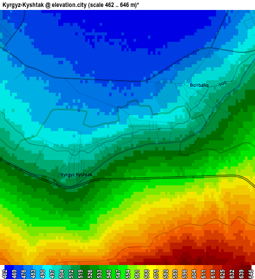
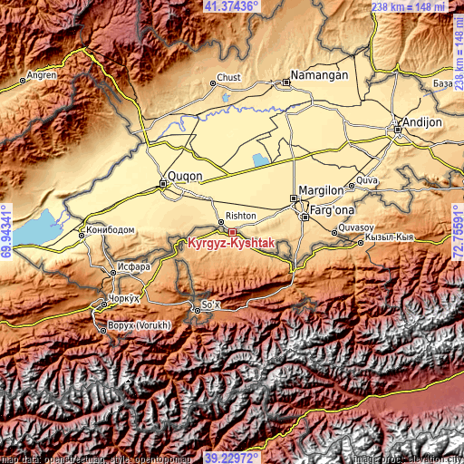
| \ | Map #1 | Topo.Map |
| Scale [m] | 462..646 m | × |
| Scale [ft] | 1516..2119 ft | × |
| Average | 521.6 m = 1711 ft | × |
| Width | 7.45 km = 4.6 mi | 238.5 km = 148.2 mi |
| Height | 7.45 km = 4.6 mi | 238.5 km = 148.2 mi |
| ↑Max Latitude | 40.344052° | 41.37436° |
| Latitude at center | 40.31055° | 40.31055° |
| ↓Min Latitude | 40.277031° | 39.22972° |
| ← Min Longitude | 71.305715° | 69.94341° |
| Longitude center | 71.34966° | 71.34966° |
| →Max Longitude | 71.393605° | 72.75591° |
Nearby cities:
Cities around Kyrgyz-Kyshtak sort by population:
• Aydarken elevation 1928 m
40.9 km,  180°
180°
• Tayan 1279 m
49.8 km,  204°
204°
• Chek 926 m
48.2 km,  242°
242°
• Kara-Bak 820 m
47.9 km,  249°
249°
• Markaz 808 m
47.3 km,  99°
99°
• Kyzyl-Bulak 1222 m
43.7 km,  131°
131°
• Boz-Adyr 1185 m
41.9 km,  214°
214°
• Ormosh 1648 m
41.2 km,  190°
190°
• Orozbekovo 1242 m
39.2 km,  136°
136°
• Pulgon 982 m
37 km,  119°
119°
• Khalmion 756 m
26.4 km,  114°
114°
• Alga 716 m
15.1 km, 123°
Multilingual:
 En español:
Kyrgyz-Kyshtak elevación 504 m.
 En France:
Kyrgyz-Kyshtak élévation 504 m.
 Auf Deutsch:
Kyrgyz-Kyshtak höhe über dem Meeresspiegel ist 504 m.
 На русском:
Киргиз-Кыштак, Кыргыз-Кыштак высота над уровнем моря 504 м
Sources and notes:
- [note 1] Map square and city borders are not equal. Map elevation data is calculated only from area inside that square.
- [src 1] Elevation data from geonames database provided with same terms of usage.
- [src 2] The elevation map of Kyrgyz-Kyshtak is generated using elevation data from NASA's 3 arcsec (90m) resolution SRTM data.
- [src 3] Base (background) map © OpenStreetMap contributors tiles are generated by Geofabrik and OpenTopoMap.
Copyright & License:
This Kyrgyz-Kyshtak Elevation Map is licensed under CC BY-SA. You may reuse any part from this page, if you give a proper credit by linking to this URL:
 More info on terms of use page.