Ash Shūnah ash Shamālīyah elevation
Ash Shūnah ash Shamālīyah (Irbid), Jordan elevation is -196 meters and Ash Shūnah ash Shamālīyah elevation in feet is -643 ft above sea level [src 1]. Ash Shūnah ash Shamālīyah is a seat of a second-order administrative division (feature code) with elevation that is 888 meters (2913 ft) smaller than average city elevation in Jordan.
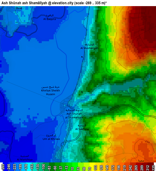
Below is the Elevation map of Ash Shūnah ash Shamālīyah, which displays elevation range with different colors. Scale of the first map is from -269 to 335 m (-883 to 1099 ft) with average elevation of -91 meters (=-299 ft) [note 1]
These maps also provides idea of topography and contour of this city, they are displayed at different zoom levels. More info about maps, scale and edge coordinates you can find below images.
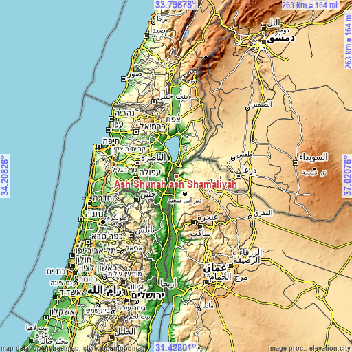
| \ | Map #1 | Topo.Map |
| Scale [m] | -269..335 m | × |
| Scale [ft] | -883..1099 ft | × |
| Average | -91 m = -299 ft | × |
| Width | 8.23 km = 5.1 mi | 263.4 km = 163.7 mi |
| Height | 8.23 km = 5.1 mi | 263.4 km = 163.7 mi |
| ↑Max Latitude | 32.657236° | 33.79678° |
| Latitude at center | 32.62023° | 32.62023° |
| ↓Min Latitude | 32.583209° | 31.42801° |
| ← Min Longitude | 35.570565° | 34.20826° |
| Longitude center | 35.61451° | 35.61451° |
| →Max Longitude | 35.658455° | 37.02076° |
Nearby cities:
Cities around Ash Shūnah ash Shamālīyah sort by population:
• Aţ Ţayyibah elevation 388 m
12.9 km,  131°
131°
• Şammā 320 m
8.9 km, 127°
• Kafr Asad 353 m
9.5 km,  105°
105°
• Kafr Sawm 435 m
18.9 km,  67°
67°
• Malkā 420 m
14 km,  63°
63°
• Saḩam al Kaffārāt 402 m
17.3 km, 59°
• Waqqāş -192 m
8.7 km,  185°
185°
• Ḩātim 420 m
15.5 km,  79°
79°
• Qumaym 383 m
12.5 km,  115°
115°
• Umm Qays 348 m
7.5 km, 60°
• Zaḩar 437 m
16.4 km, 111°
• Dayr Abū Sa‘īd 359 m
15.2 km,  153°
153°
Multilingual:
 En español:
Ash Shūnah ash Shamālīyah elevación -196 m.
 En France:
Ash Shūnah ash Shamālīyah élévation -196 m.
 Auf Deutsch:
Ash Shūnah ash Shamālīyah höhe über dem Meeresspiegel ist -196 m.
 На русском:
Ash Shūnah ash Shamālīyah высота над уровнем моря -196 м
Sources and notes:
- [note 1] Map square and city borders are not equal. Map elevation data is calculated only from area inside that square.
- [src 1] Elevation data from geonames database provided with same terms of usage.
- [src 2] The elevation map of Ash Shūnah ash Shamālīyah is generated using elevation data from NASA's 3 arcsec (90m) resolution SRTM data.
- [src 3] Base (background) map © OpenStreetMap contributors tiles are generated by Geofabrik and OpenTopoMap.
Copyright & License:
This Ash Shūnah ash Shamālīyah Elevation Map is licensed under CC BY-SA. You may reuse any part from this page, if you give a proper credit by linking to this URL:
 More info on terms of use page.