‘Ayy elevation
‘Ayy (Karak), Jordan elevation is 909 meters and ‘Ayy elevation in feet is 2982 ft above sea level [src 1]. ‘Ayy is a seat of a second-order administrative division (feature code) with elevation that is 217 meters (712 ft) bigger than average city elevation in Jordan.
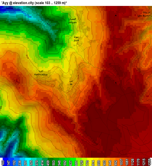
Below is the Elevation map of ‘Ayy, which displays elevation range with different colors. Scale of the first map is from 103 to 1259 m (338 to 4131 ft) with average elevation of 938.3 meters (=3078 ft) [note 1]
These maps also provides idea of topography and contour of this city, they are displayed at different zoom levels. More info about maps, scale and edge coordinates you can find below images.
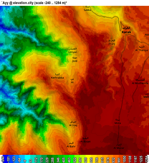
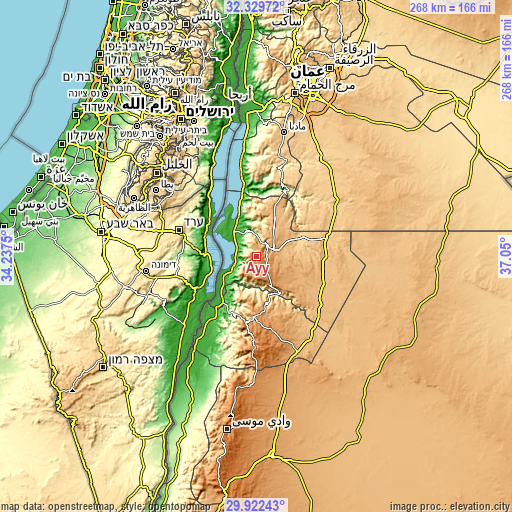
| \ | Map #1 | Map #2 | Topo.Map |
| Scale [m] | 103..1259 m | -240..1284 m | × |
| Scale [ft] | 338..4131 ft | -787..4213 ft | × |
| Average | 938.3 m = 3078 ft | 821.4 m = 2695 ft | × |
| Width | 8.36 km = 5.2 mi | 16.73 km = 10.4 mi | 267.7 km = 166.3 mi |
| Height | 8.36 km = 5.2 mi | 16.73 km = 10.4 mi | 267.7 km = 166.3 mi |
| ↑Max Latitude | 31.171318° | 31.208911° | 32.32972° |
| Latitude at center | 31.13371° | 31.13371° | 31.13371° |
| ↓Min Latitude | 31.096087° | 31.058449° | 29.92243° |
| ← Min Longitude | 35.599805° | 35.555859° | 34.2375° |
| Longitude center | 35.64375° | 35.64375° | 35.64375° |
| →Max Longitude | 35.687695° | 35.731641° | 37.05° |
Nearby cities:
Cities around ‘Ayy sort by population:
• ‘Izrā elevation 1111 m
5.4 km,  59°
59°
• Qīr Moāv 888 m
7.6 km,  44°
44°
• Karak City 948 m
11.7 km,  73°
73°
• Safi -366 m
20.2 km,  237°
237°
• Al Mazār al Janūbī 1239 m
8.9 km,  146°
146°
• Al Khinzīrah 1067 m
9.9 km,  201°
201°
• Adir 966 m
13.5 km, 55°
• Ar Rabbah 964 m
17.5 km,  30°
30°
• Al Qaşr 933 m
22.2 km, 25°
• Fuqū‘ 908 m
26.6 km,  12°
12°
• Ghawr al Mazra‘ah -346 m
19 km,  320°
320°
• Al Ḩusaynīyah 1213 m
14.1 km, 147°
Multilingual:
 En español:
‘Ayy elevación 909 m.
 En France:
‘Ayy élévation 909 m.


Sources and notes:
- [note 1] Map square and city borders are not equal. Map elevation data is calculated only from area inside that square.
- [src 1] Elevation data from geonames database provided with same terms of usage.
- [src 2] The elevation map of ‘Ayy is generated using elevation data from NASA's 3 arcsec (90m) resolution SRTM data.
- [src 3] Base (background) map © OpenStreetMap contributors tiles are generated by Geofabrik and OpenTopoMap.
Copyright & License:
This ‘Ayy Elevation Map is licensed under CC BY-SA. You may reuse any part from this page, if you give a proper credit by linking to this URL:
 More info on terms of use page.