Kafr Abīl elevation
Kafr Abīl (Irbid), Jordan elevation is 440 meters and Kafr Abīl elevation in feet is 1444 ft above sea level [src 1]. Kafr Abīl is a populated place (feature code) with elevation that is 252 meters (827 ft) smaller than average city elevation in Jordan.
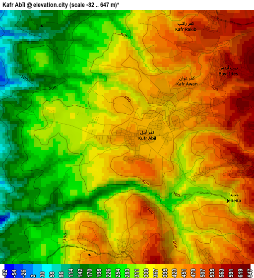
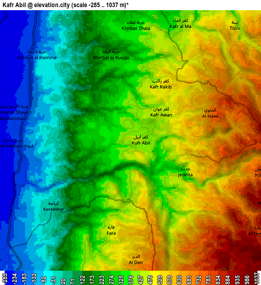
Below is the Elevation map of Kafr Abīl, which displays elevation range with different colors. Scale of the first map is from -82 to 647 m (-269 to 2123 ft) with average elevation of 351.1 meters (=1152 ft) [note 1]
These maps also provides idea of topography and contour of this city, they are displayed at different zoom levels. More info about maps, scale and edge coordinates you can find below images.
| \ | Map #1 | Map #2 | Topo.Map |
| Scale [m] | -82..647 m | -285..1037 m | × |
| Scale [ft] | -269..2123 ft | -935..3402 ft | × |
| Average | 351.1 m = 1152 ft | 327.1 m = 1073 ft | × |
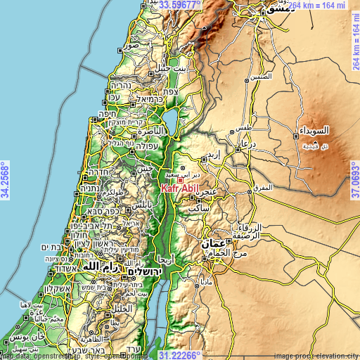
| Width | 8.25 km = 5.1 mi | 16.5 km = 10.3 mi | 264 km = 164 mi |
| Height | 8.25 km = 5.1 mi | 16.5 km = 10.3 mi | 264 km = 164 mi |
| ↑Max Latitude | 32.454609° | 32.491684° | 33.59677° |
| Latitude at center | 32.41752° | 32.41752° | 32.41752° |
| ↓Min Latitude | 32.380415° | 32.343295° | 31.22266° |
| ← Min Longitude | 35.619105° | 35.575159° | 34.2568° |
| Longitude center | 35.66305° | 35.66305° | 35.66305° |
| →Max Longitude | 35.706995° | 35.750941° | 37.0693° |
Nearby cities:
Cities around Kafr Abīl sort by population:
• ‘Ajlūn elevation 769 m
12.6 km,  138°
138°
• Judita 586 m
4.4 km,  104°
104°
• Aţ Ţayyibah 388 m
14.9 km,  20°
20°
• ‘Ayn Jannah 871 m
13.2 km,  134°
134°
• Dayr Yūsuf 752 m
14.7 km,  58°
58°
• Ḩalāwah 407 m
3.7 km,  182°
182°
• Tibnah 569 m
9 km,  44°
44°
• Bayt Īdis 558 m
4 km, 55°
• Al Mazār ash Shamālī 831 m
13.9 km, 64°
• Kufrinjah 618 m
13.8 km,  164°
164°
• Dayr Abū Sa‘īd 359 m
9.2 km,  13°
13°
• ‘Irjān 651 m
7.1 km,  111°
111°
Multilingual:
 En español:
Kafr Abīl elevación 440 m.
 En France:
Kafr Abīl élévation 440 m.
 Auf Deutsch:
Kafr Abīl höhe über dem Meeresspiegel ist 440 m.

Sources and notes:
- [note 1] Map square and city borders are not equal. Map elevation data is calculated only from area inside that square.
- [src 1] Elevation data from geonames database provided with same terms of usage.
- [src 2] The elevation map of Kafr Abīl is generated using elevation data from NASA's 3 arcsec (90m) resolution SRTM data.
- [src 3] Base (background) map © OpenStreetMap contributors tiles are generated by Geofabrik and OpenTopoMap.
Copyright & License:
This Kafr Abīl Elevation Map is licensed under CC BY-SA. You may reuse any part from this page, if you give a proper credit by linking to this URL:
 More info on terms of use page.