Ma'an elevation
Ma'an (Ma’an), Jordan elevation is 1111 meters and Ma'an elevation in feet is 3645 ft above sea level [src 1]. Ma'an is a seat of a first-order administrative division (feature code) with elevation that is 419 meters (1375 ft) bigger than average city elevation in Jordan.
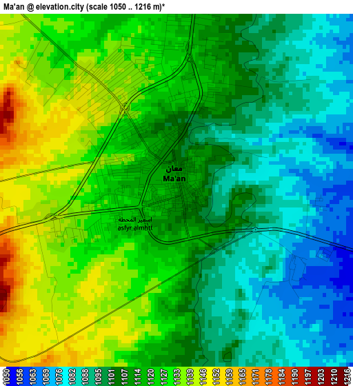
Below is the Elevation map of Ma'an, which displays elevation range with different colors. Scale of the first map is from 1050 to 1216 m (3445 to 3990 ft) with average elevation of 1112.8 meters (=3651 ft) [note 1]
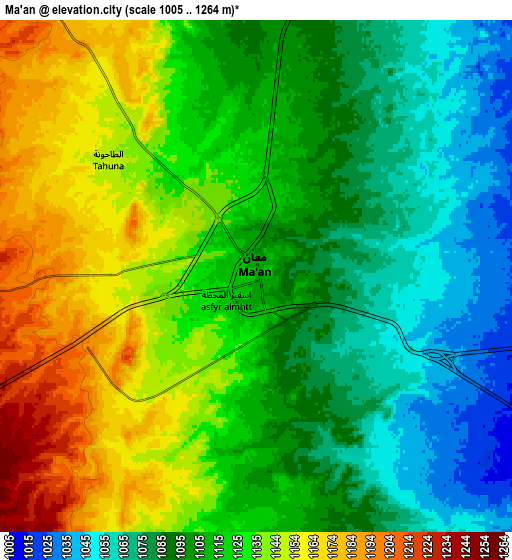
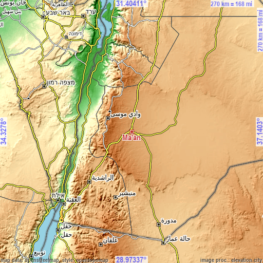
These maps also provides idea of topography and contour of this city, they are displayed at different zoom levels. More info about maps, scale and edge coordinates you can find below images.
| \ | Map #1 | Map #2 | Topo.Map |
| Scale [m] | 1050..1216 m | 1005..1264 m | × |
| Scale [ft] | 3445..3990 ft | 3297..4147 ft | × |
| Average | 1112.8 m = 3651 ft | 1114.1 m = 3655 ft | × |
| Width | 8.45 km = 5.3 mi | 16.89 km = 10.5 mi | 270.3 km = 168 mi |
| Height | 8.45 km = 5.3 mi | 16.89 km = 10.5 mi | 270.3 km = 168 mi |
| ↑Max Latitude | 30.234215° | 30.272175° | 31.40411° |
| Latitude at center | 30.19624° | 30.19624° | 30.19624° |
| ↓Min Latitude | 30.15825° | 30.120246° | 28.97337° |
| ← Min Longitude | 35.690105° | 35.646159° | 34.3278° |
| Longitude center | 35.73405° | 35.73405° | 35.73405° |
| →Max Longitude | 35.777995° | 35.821941° | 37.1403° |
Nearby cities:
Cities around Ma'an sort by population:
• Petra elevation 1127 m
28.2 km,  299°
299°
• Al Quwayrah 813 m
59.9 km,  222°
222°
• Buşayrā 1124 m
60.8 km,  348°
348°
• Aţ Ţayyibah 1420 m
26.5 km,  283°
283°
• Al Jafr 864 m
44.7 km,  72°
72°
• Ash Shawbak 1331 m
39.4 km,  336°
336°
• Ad Dīsah 797 m
64.1 km,  199°
199°
• Ar Rīshah 256 m
49.8 km,  273°
273°
• Al Ḩusaynīyah 1062 m
44.8 km,  7°
7°
• Al Murayghah 1387 m
23.2 km,  241°
241°
• Adhruḩ 1299 m
19.9 km,  318°
318°
• Ayl 1440 m
19 km, 273°
Multilingual:
 En español:
Ma'an elevación 1111 m.
 En France:
Ma'an élévation 1111 m.


Sources and notes:
- [note 1] Map square and city borders are not equal. Map elevation data is calculated only from area inside that square.
- [src 1] Elevation data from geonames database provided with same terms of usage.
- [src 2] The elevation map of Ma'an is generated using elevation data from NASA's 3 arcsec (90m) resolution SRTM data.
- [src 3] Base (background) map © OpenStreetMap contributors tiles are generated by Geofabrik and OpenTopoMap.
Copyright & License:
This Ma'an Elevation Map is licensed under CC BY-SA. You may reuse any part from this page, if you give a proper credit by linking to this URL:
 More info on terms of use page.