Maggotty elevation
Maggotty (St. Elizabeth, Carisbrook), Jamaica elevation is 117 meters and Maggotty elevation in feet is 384 ft above sea level [src 1]. Maggotty is a populated place (feature code) with elevation that is 98 meters (322 ft) smaller than average city elevation in Jamaica.
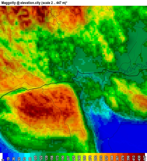
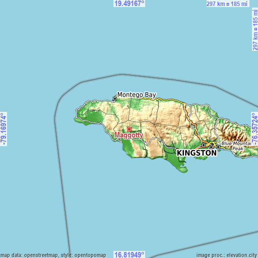
Below is the Elevation map of Maggotty, which displays elevation range with different colors. Scale of the first map is from 2 to 447 m (7 to 1467 ft) with average elevation of 210.5 meters (=691 ft) [note 1]
These maps also provides idea of topography and contour of this city, they are displayed at different zoom levels. More info about maps, scale and edge coordinates you can find below images.
| \ | Map #1 | Topo.Map |
| Scale [m] | 2..447 m | × |
| Scale [ft] | 7..1467 ft | × |
| Average | 210.5 m = 691 ft | × |
| Width | 9.29 km = 5.8 mi | 297.1 km = 184.6 mi |
| Height | 9.29 km = 5.8 mi | 297.1 km = 184.6 mi |
| ↑Max Latitude | 18.202441° | 19.49167° |
| Latitude at center | 18.16069° | 18.16069° |
| ↓Min Latitude | 18.118929° | 16.81949° |
| ← Min Longitude | -77.807435° | -79.16974° |
| Longitude center | -77.76349° | -77.76349° |
| →Max Longitude | -77.719545° | -76.35724° |
Nearby cities:
Cities around Maggotty sort by population:
• Santa Cruz elevation 13 m
13.8 km,  150°
150°
• Black River 5 m
17.4 km,  211°
211°
• Cambridge 181 m
22.4 km,  319°
319°
• Malvern 662 m
22.6 km,  162°
162°
• Lacovia 110 m
9.9 km,  172°
172°
• Maroon Town 441 m
20.7 km,  350°
350°
• Bethel Town 292 m
24.8 km,  307°
307°
• Balaclava 230 m
12.7 km,  84°
84°
• Siloah 141 m
6.4 km, 83°
• Darliston 422 m
24 km,  290°
290°
• Rock Spring 607 m
27.2 km,  54°
54°
• Quickstep 685 m
16.8 km, 47°
Multilingual:
 En español:
Maggotty elevación 117 m.
 En France:
Maggotty élévation 117 m.
 Auf Deutsch:
Maggotty höhe über dem Meeresspiegel ist 117 m.

Sources and notes:
- [note 1] Map square and city borders are not equal. Map elevation data is calculated only from area inside that square.
- [src 1] Elevation data from geonames database provided with same terms of usage.
- [src 2] The elevation map of Maggotty is generated using elevation data from NASA's 3 arcsec (90m) resolution SRTM data.
- [src 3] Base (background) map © OpenStreetMap contributors tiles are generated by Geofabrik and OpenTopoMap.
Copyright & License:
This Maggotty Elevation Map is licensed under CC BY-SA. You may reuse any part from this page, if you give a proper credit by linking to this URL:
 More info on terms of use page.