Hafnarfjörður elevation
Hafnarfjörður (Capital Region, Hafnarfjarðarkaupstaður), Iceland elevation is 39 meters and Hafnarfjörður elevation in feet is 128 ft above sea level [src 1]. Hafnarfjörður is a populated place (feature code) with elevation that is 20 meters (66 ft) bigger than average city elevation in Iceland.
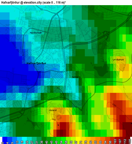
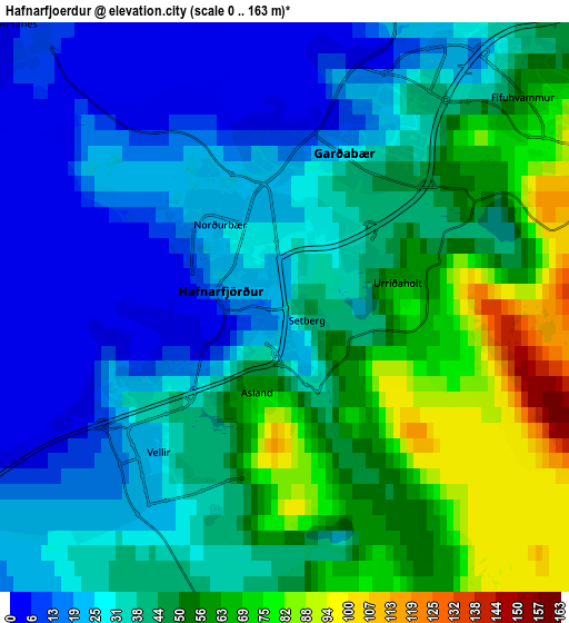
Below is the Elevation map of Hafnarfjörður, which displays elevation range with different colors. Scale of the first map is from 0 to 116 m (0 to 381 ft) with average elevation of 38.4 meters (=126 ft) [note 1]
These maps also provides idea of topography and contour of this city, they are displayed at different zoom levels. More info about maps, scale and edge coordinates you can find below images.
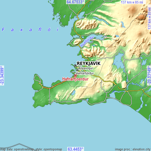
| \ | Map #1 | Map #2 | Topo.Map |
| Scale [m] | 0..116 m | 0..163 m | × |
| Scale [ft] | 0..381 ft | 0..535 ft | × |
| Average | 38.4 m = 126 ft | 39.8 m = 131 ft | × |
| Width | 4.27 km = 2.7 mi | 8.55 km = 5.3 mi | 136.8 km = 85 mi |
| Height | 4.27 km = 2.7 mi | 8.55 km = 5.3 mi | 136.7 km = 84.9 mi |
| ↑Max Latitude | 64.086311° | 64.10551° | 64.67533° |
| Latitude at center | 64.0671° | 64.0671° | 64.0671° |
| ↓Min Latitude | 64.047875° | 64.028637° | 63.4453° |
| ← Min Longitude | -21.981685° | -22.025631° | -23.34399° |
| Longitude center | -21.93774° | -21.93774° | -21.93774° |
| →Max Longitude | -21.893795° | -21.849849° | -20.53149° |
Nearby cities:
Cities around Hafnarfjörður sort by population:
• Reykjavík elevation 37 m
7.9 km,  15°
15°
• Kópavogur 37 m
5.2 km,  13°
13°
• Garðabær 41 m
2.5 km, 16°
• Mosfellsbær 22 m
16 km,  46°
46°
• Akranes 8 m
29.1 km,  346°
346°
• Seltjarnarnes 9 m
10 km,  343°
343°
• Grindavík 1 m
35.3 km,  223°
223°
• Álftanes 1 m
5.3 km,  313°
313°
• Reykjanesbær 13 m
31.3 km,  255°
255°
• Garður 20 m
34.5 km,  269°
269°
• Vogar 7 m
23.8 km,  246°
246°
• Keflavík 5 m
31.2 km, 257°
Multilingual:
 En español:
Hafnarfjörður elevación 39 m.
 En France:
Hafnarfjörður élévation 39 m.
 Auf Deutsch:
Hafnarfjörður höhe über dem Meeresspiegel ist 39 m.

Sources and notes:
- [note 1] Map square and city borders are not equal. Map elevation data is calculated only from area inside that square.
- [src 1] Elevation data from geonames database provided with same terms of usage.
- [src 2] The elevation map of Hafnarfjörður is generated using GMTED2010 database with 7.5 arcsec (225m) resolution.
- [src 3] Base (background) map © OpenStreetMap contributors tiles are generated by Geofabrik and OpenTopoMap.
Copyright & License:
This Hafnarfjörður Elevation Map is licensed under CC BY-SA. You may reuse any part from this page, if you give a proper credit by linking to this URL:
 More info on terms of use page.