Torbat-e Jām elevation
Torbat-e Jām (Razavi Khorasan), Iran elevation is 908 meters and Torbat-e Jām elevation in feet is 2979 ft above sea level [src 1]. Torbat-e Jām is a seat of a second-order administrative division (feature code) with elevation that is 136 meters (446 ft) smaller than average city elevation in Iran.
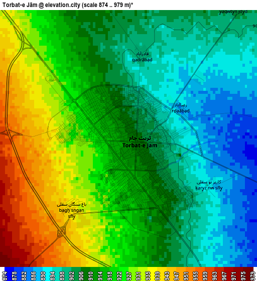
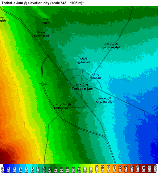
Below is the Elevation map of Torbat-e Jām, which displays elevation range with different colors. Scale of the first map is from 874 to 979 m (2867 to 3212 ft) with average elevation of 914.5 meters (=3000 ft) [note 1]
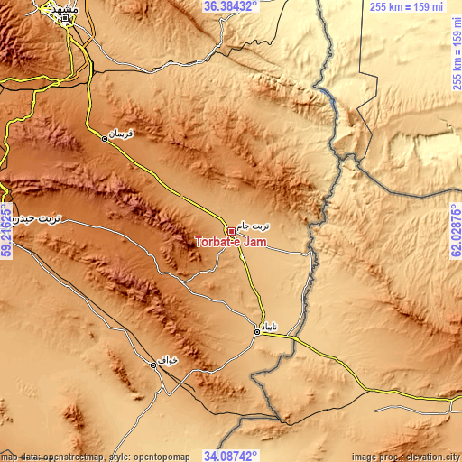
These maps also provides idea of topography and contour of this city, they are displayed at different zoom levels. More info about maps, scale and edge coordinates you can find below images.
| \ | Map #1 | Map #2 | Topo.Map |
| Scale [m] | 874..979 m | 843..1098 m | × |
| Scale [ft] | 2867..3212 ft | 2766..3602 ft | × |
| Average | 914.5 m = 3000 ft | 928.7 m = 3047 ft | × |
| Width | 7.98 km = 5 mi | 15.96 km = 9.9 mi | 255.4 km = 158.7 mi |
| Height | 7.98 km = 5 mi | 15.96 km = 9.9 mi | 255.4 km = 158.7 mi |
| ↑Max Latitude | 35.279882° | 35.315749° | 36.38432° |
| Latitude at center | 35.244° | 35.244° | 35.244° |
| ↓Min Latitude | 35.208102° | 35.172188° | 34.08742° |
| ← Min Longitude | 60.578555° | 60.534609° | 59.21625° |
| Longitude center | 60.6225° | 60.6225° | 60.6225° |
| →Max Longitude | 60.666445° | 60.710391° | 62.02875° |
Nearby cities:
Cities around Torbat-e Jām sort by population:
• Mashhad elevation 1003 m
152.5 km,  321°
321°
• Torbat-e Ḩeydarīyeh 1351 m
127.4 km,  271°
271°
• Sarakhs 276 m
152.5 km,  18°
18°
• Tāybād 811 m
57.7 km,  166°
166°
• Ḩājjīābād 1038 m
191.2 km,  197°
197°
• Feyẕābād 931 m
169.1 km,  261°
261°
• Ţorqabeh 1316 m
163.6 km, 316°
• Dowlatābād 1369 m
100.2 km, 272°
• Roshtkhvār 1149 m
95.5 km,  251°
251°
• Farīmān 1398 m
86.8 km,  306°
306°
• Khvāf 975 m
86.3 km,  210°
210°
• Shahrak-e Bākharz 1276 m
39.4 km,  224°
224°
Multilingual:
 En español:
Torbat-e Jām elevación 908 m.
 En France:
Torbat-e Jām élévation 908 m.
 Auf Deutsch:
Torbat-e Jām höhe über dem Meeresspiegel ist 908 m.

Sources and notes:
- [note 1] Map square and city borders are not equal. Map elevation data is calculated only from area inside that square.
- [src 1] Elevation data from geonames database provided with same terms of usage.
- [src 2] The elevation map of Torbat-e Jām is generated using elevation data from NASA's 3 arcsec (90m) resolution SRTM data.
- [src 3] Base (background) map © OpenStreetMap contributors tiles are generated by Geofabrik and OpenTopoMap.
Copyright & License:
This Torbat-e Jām Elevation Map is licensed under CC BY-SA. You may reuse any part from this page, if you give a proper credit by linking to this URL:
 More info on terms of use page.