Pasragad Branch elevation
Pasragad Branch (Hamadān), Iran elevation is 2010 meters and Pasragad Branch elevation in feet is 6594 ft above sea level [src 1]. Pasragad Branch is a populated place (feature code) with elevation that is 966 meters (3169 ft) bigger than average city elevation in Iran.
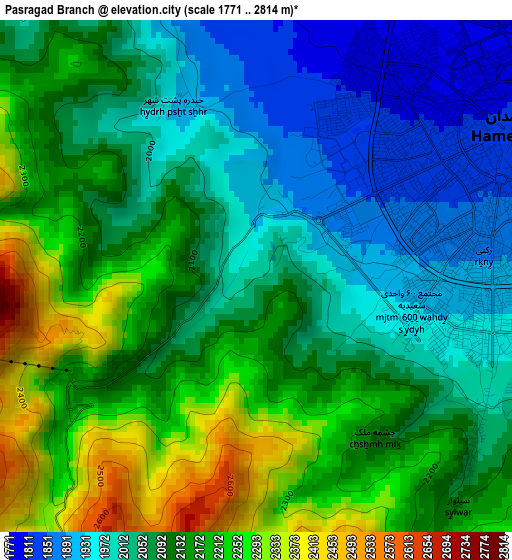
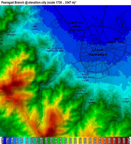
Below is the Elevation map of Pasragad Branch, which displays elevation range with different colors. Scale of the first map is from 1771 to 2814 m (5810 to 9232 ft) with average elevation of 2098.1 meters (=6884 ft) [note 1]
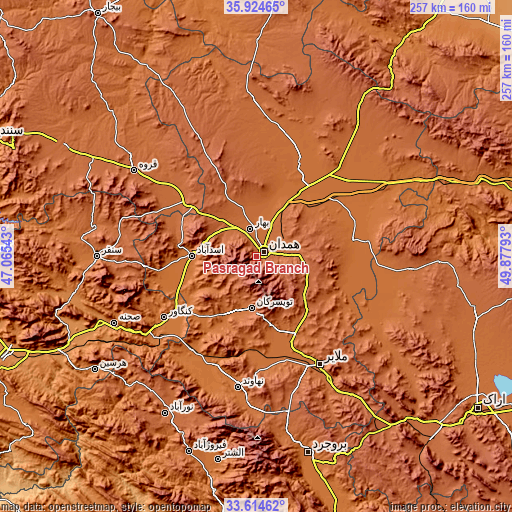
These maps also provides idea of topography and contour of this city, they are displayed at different zoom levels. More info about maps, scale and edge coordinates you can find below images.
| \ | Map #1 | Map #2 | Topo.Map |
| Scale [m] | 1771..2814 m | 1730..3347 m | × |
| Scale [ft] | 5810..9232 ft | 5676..10981 ft | × |
| Average | 2098.1 m = 6884 ft | 2202.4 m = 7226 ft | × |
| Width | 8.03 km = 5 mi | 16.05 km = 10 mi | 256.9 km = 159.6 mi |
| Height | 8.03 km = 5 mi | 16.05 km = 10 mi | 256.9 km = 159.6 mi |
| ↑Max Latitude | 34.813808° | 34.849879° | 35.92465° |
| Latitude at center | 34.77772° | 34.77772° | 34.77772° |
| ↓Min Latitude | 34.741617° | 34.705498° | 33.61462° |
| ← Min Longitude | 48.427735° | 48.383789° | 47.06543° |
| Longitude center | 48.47168° | 48.47168° | 48.47168° |
| →Max Longitude | 48.515625° | 48.559571° | 49.87793° |
Nearby cities:
Cities around Pasragad Branch sort by population:
• Hamadān elevation 1820 m
4.6 km,  58°
58°
• Āzādshahr 1853 m
9.1 km,  81°
81°
• Malāyer 1760 m
61.9 km,  148°
148°
• Qorveh 1909 m
74.5 km,  305°
305°
• Nahāvand 1673 m
65.9 km,  187°
187°
• Asadābād 1596 m
32.1 km,  270°
270°
• Kangāvar 1476 m
55.4 km,  236°
236°
• Bahār 1722 m
14.7 km,  349°
349°
• Anūch 1935 m
75 km,  172°
172°
• Fāmenīn 1637 m
59.2 km,  50°
50°
• Kabūdarāhang 1670 m
53.2 km,  25°
25°
• Tūyserkān 1829 m
25.3 km, 185°
Multilingual:
 En español:
Pasragad Branch elevación 2010 m.
 En France:
Pasragad Branch élévation 2010 m.
 Auf Deutsch:
Pasragad Branch höhe über dem Meeresspiegel ist 2010 m.

Sources and notes:
- [note 1] Map square and city borders are not equal. Map elevation data is calculated only from area inside that square.
- [src 1] Elevation data from geonames database provided with same terms of usage.
- [src 2] The elevation map of Pasragad Branch is generated using elevation data from NASA's 3 arcsec (90m) resolution SRTM data.
- [src 3] Base (background) map © OpenStreetMap contributors tiles are generated by Geofabrik and OpenTopoMap.
Copyright & License:
This Pasragad Branch Elevation Map is licensed under CC BY-SA. You may reuse any part from this page, if you give a proper credit by linking to this URL:
 More info on terms of use page.