Ābyek elevation
Ābyek (Markazi), Iran elevation is 1454 meters and Ābyek elevation in feet is 4770 ft above sea level [src 1]. Ābyek is a populated place (feature code) with elevation that is 410 meters (1345 ft) bigger than average city elevation in Iran.
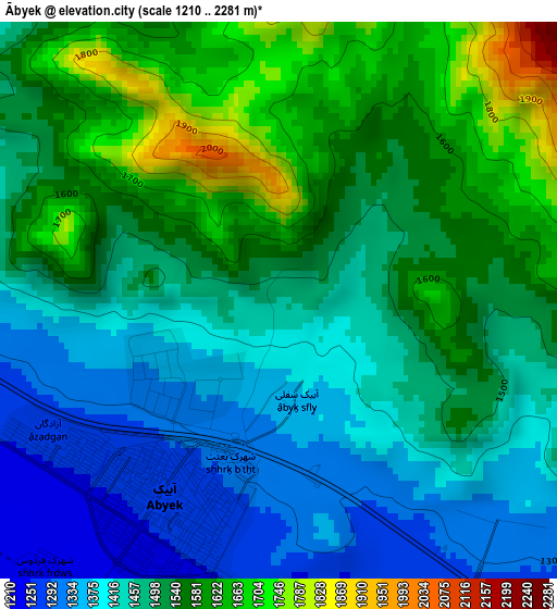
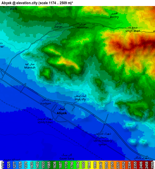
Below is the Elevation map of Ābyek, which displays elevation range with different colors. Scale of the first map is from 1210 to 2281 m (3970 to 7484 ft) with average elevation of 1498.1 meters (=4915 ft) [note 1]
These maps also provides idea of topography and contour of this city, they are displayed at different zoom levels. More info about maps, scale and edge coordinates you can find below images.
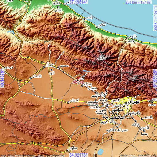
| \ | Map #1 | Map #2 | Topo.Map |
| Scale [m] | 1210..2281 m | 1174..2509 m | × |
| Scale [ft] | 3970..7484 ft | 3852..8232 ft | × |
| Average | 1498.1 m = 4915 ft | 1498.4 m = 4916 ft | × |
| Width | 7.9 km = 4.9 mi | 15.8 km = 9.8 mi | 252.8 km = 157.1 mi |
| Height | 7.9 km = 4.9 mi | 15.8 km = 9.8 mi | 252.8 km = 157.1 mi |
| ↑Max Latitude | 36.102184° | 36.137683° | 37.19514° |
| Latitude at center | 36.06667° | 36.06667° | 36.06667° |
| ↓Min Latitude | 36.03114° | 35.995593° | 34.92178° |
| ← Min Longitude | 50.506055° | 50.462109° | 49.14375° |
| Longitude center | 50.55° | 50.55° | 50.55° |
| →Max Longitude | 50.593945° | 50.637891° | 51.95625° |
Nearby cities:
Cities around Ābyek sort by population:
• Karaj elevation 1341 m
47.5 km,  123°
123°
• Qazvin 1300 m
53.9 km,  294°
294°
• Naz̧arābād 1199 m
13.5 km,  158°
158°
• Alvand 1243 m
45.7 km, 287°
• Shahre Jadide Andisheh 1180 m
60.3 km,  135°
135°
• Malārd 1163 m
58.9 km, 139°
• Shahr-e Qods 1181 m
63.3 km,  127°
127°
• Bū’īn Zahrā 1217 m
55.5 km,  233°
233°
• Eshtehārd 1161 m
41.4 km,  203°
203°
• Shahrak 1823 m
23 km,  58°
58°
• Hashtgerd 1272 m
16.5 km, 134°
• Ābyek 1258 m
3.4 km,  209°
209°
Multilingual:
 En español:
Ābyek elevación 1454 m.
 En France:
Ābyek élévation 1454 m.


Sources and notes:
- [note 1] Map square and city borders are not equal. Map elevation data is calculated only from area inside that square.
- [src 1] Elevation data from geonames database provided with same terms of usage.
- [src 2] The elevation map of Ābyek is generated using elevation data from NASA's 3 arcsec (90m) resolution SRTM data.
- [src 3] Base (background) map © OpenStreetMap contributors tiles are generated by Geofabrik and OpenTopoMap.
Copyright & License:
This Ābyek Elevation Map is licensed under CC BY-SA. You may reuse any part from this page, if you give a proper credit by linking to this URL:
 More info on terms of use page.